geo.wikisort.org - Mountains
Mont Choungui is a distinctively conical volcanic mountain in the southern part of the French island of Mayotte, in the Comoro archipelago of the western Indian Ocean. It is the second highest point of the island at 593 m (1,946 ft), the highest being Mont Bénara, and is visible from far out at sea.[1][2] [3]
| Mont Choungui | |
|---|---|
 | |
| Highest point | |
| Elevation | 593 m (1,946 ft) |
| Coordinates | 12°57′25″S 45°08′02″E |
| Geography | |
Mont Choungui Location on Mayotte | |
| Location | Near Choungui, Kani-Keli, Mayotte, French Overseas Territories |
 Plane view.
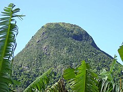 Summit.
 View from the mont, heading southward.


Important Bird Area
Choungui dominates the southern peninsula of the island. Its south-easternmost headland, Pointe Saziley, is 4 km long with a sharp ridge rising to 233 m. Forest covers the peak and most of the catchment of the Mroni Bé river, while Sazilé is vegetated with dry shrubland and thickets containing baobabs. The 1600 ha site has been identified as an Important Bird Area (IBA) by BirdLife International because it supports significant populations of Comoro olive-pigeons, Comoro blue-pigeons, Mayotte white-eyes, Mayotte sunbirds and red-headed fodies. It is also home to Robert Mertens's day geckos, island day geckos and Pasteur's day geckos. Sazilé's beaches are a nesting site for green, and probably hawksbill, sea turtles.[4]
References
- Great Britain. Hydrographic Dept (1990). South Indian Ocean pilot: Comores, Madagascar, Seychelles Group, La Réunion, Mauritius, Chagos Archipelago, and other islands lying westward of longitude 900 East. Hydrographer of the Navy. p. 64. Retrieved 29 June 2012.
- Suomen Biologian Seura Vanamo; Suomalainen Eläin- ja Kasvitieteellinen Seura Vanamo (1995). Annales botanici Fennici. Societas Biologica Fennica Vanamo. Retrieved 29 June 2012.
- Auzias, Dominique; Labourdette, Jean-Paul (2008). Mayotte. Petit Futé. p. 173. ISBN 978-2-7469-1967-9. Retrieved 29 June 2012.
- "Mlima Choungui and Sazilé". Important Bird Areas factsheet. BirdLife International. 2013. Retrieved 2013-09-04.
External links
This Mayotte location article is a stub. You can help Wikipedia by expanding it. |
На других языках
- [en] Mont Choungui
[fr] Mont Choungui
Le mont Choungui est un sommet du Sud de l'île de Grande-Terre à Mayotte culminant à 593 mètres d'altitude, à cheval sur les communes de Kani-Kéli et Chirongui.[ru] Шунги (гора)
Шунги (фр. Choungui) — вулкан характерной конической формы, расположенный в заморском регионе Франции Майотте. Расположен на острове Майотта, принадлежащем к цепи Коморских островов. При высоте в 593 метра является одной из самых высоких точек региона, по высоте уступает только горе Бенара[2][3][4].Другой контент может иметь иную лицензию. Перед использованием материалов сайта WikiSort.org внимательно изучите правила лицензирования конкретных элементов наполнения сайта.
WikiSort.org - проект по пересортировке и дополнению контента Википедии