geo.wikisort.org - Mountains
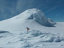
Miziya Peak (Bulgarian: връх Мизия, romanized: vrah Miziya, IPA: [ˈvrɤx ˈmizijɐ]) is the 604 m summit of Vidin Heights on Varna Peninsula, eastern Livingston Island in the South Shetland Islands, Antarctica. The peak overlooks Kaliakra Glacier to the south, and Saedinenie Snowfield to the northwest. First ascent by Lyubomir Ivanov from Camp Academia on 25 December 2004, as part of Tangra 2004/05 survey.


The peak is named after the Bulgarian town of Miziya in relation to the ancient Thracian province of Miziya (Moesia).
Location
The peak is located at 62°32′08″S 60°09′52.7″W, which is 7.4 km north of Melnik Peak, 9.25 km north by east of Mount Bowles, 4.24 km north-northeast of Leslie Hill, 4.19 km north-northeast of Castra Martis Hill, 5.4 km northeast of the summit of Gleaner Heights, 4.55 km south-southeast of Kotis Point, 9.47 km south of Williams Point and 7.52 km west of Edinburgh Hill (Bulgarian topographic survey Tangra 2004/05, and mapping in 2005 and 2009).
Maps
- L.L. Ivanov et al. Antarctica: Livingston Island and Greenwich Island, South Shetland Islands. Scale 1:100000 topographic map. Sofia: Antarctic Place-names Commission of Bulgaria, 2005.
- L.L. Ivanov. Antarctica: Livingston Island and Greenwich, Robert, Snow and Smith Islands. Scale 1:120000 topographic map. Troyan: Manfred Wörner Foundation, 2009. ISBN 978-954-92032-6-4
- L.L. Ivanov. Antarctica: Livingston Island and Smith Island. Scale 1:100000 topographic map. Manfred Wörner Foundation, 2017. ISBN 978-619-90008-3-0
References
- Miziya Peak. SCAR Composite Antarctic Gazetteer
- Bulgarian Antarctic Gazetteer. Antarctic Place-names Commission. (details in Bulgarian, basic data in English)
- L.L. Ivanov, Livingston Island: Tangra Mountains, Komini Peak, west slope new rock route; Lyaskovets Peak, first ascent; Zograf Peak, first ascent; Vidin Heights, Melnik Peak, Melnik Ridge, first ascent, The American Alpine Journal, 2005, 312–315. ISSN 0065-6925
- Antarctica: Livingston Island, Climb Magazine, Issue 14, Kettering, UK, April 2006, pp. 89-91.
External links
- Miziya Peak. Copernix satellite image
This article includes information from the Antarctic Place-names Commission of Bulgaria which is used with permission.
На других языках
[de] Miziya Peak
Der Miziya Peak (englisch; bulgarisch връх Мизия .mw-parser-output .Latn{font-family:"Akzidenz Grotesk","Arial","Avant Garde Gothic","Calibri","Futura","Geneva","Gill Sans","Helvetica","Lucida Grande","Lucida Sans Unicode","Lucida Grande","Stone Sans","Tahoma","Trebuchet","Univers","Verdana"}wrach Misija) ist ein 604 m hoher Berg auf der Livingston-Insel im Archipel der Südlichen Shetlandinseln. Er ist der höchste Gipfel der Vidin Heights und ragt 5,5 km nordöstlich der Gleaner Heights, 4,3 km nordnordöstlich des Leslie Hill, 7,6 km nördlich bis westlich des Sliven Peak und 9,4 km nördlich bis östlich des Mount Bowles auf. Der Kaliakra-Gletscher liegt südlich und südöstlich von ihm.- [en] Miziya Peak
Другой контент может иметь иную лицензию. Перед использованием материалов сайта WikiSort.org внимательно изучите правила лицензирования конкретных элементов наполнения сайта.
WikiSort.org - проект по пересортировке и дополнению контента Википедии