geo.wikisort.org - Mountains
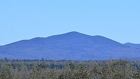
Merrill Mountain (in French: Montagne Merrill) is a mountain on the border between the Canadian province of Quebec, in the region of Estrie, and the U.S. state of Maine, which is part of the Appalachian Mountains; its altitude is 997 m (3,271 ft).[1]
| Merrill Mountain | |
|---|---|
 View of Merrill Mountain from Chemin de la Rivière-Bergeron, at Piopolis, Quebec, to the west | |
| Highest point | |
| Elevation | 997 m (3,271 ft) |
| Parent peak | White Mountains (Appalachian Mountains) |
| Coordinates | 45°28′27″N 70°41′32″W |
| Geography | |
| Location | Estrie Franklin County |
| Country | Canada États-Unis |
| Province U.S. state | Québec Maine |
| Region | Region County |
Geography

The mountain, located in the municipality of Frontenac, on the zec Louise-Gosford east of lac aux Araignées, is crossed by the Canada–United States border.[2]
Toponymy
The toponym "Montagne Merrill" was formalized on November 7, 1985, by the Commission de toponymie du Québec.[3]
See also
References
- Montagne Merrill, Commission de toponymie du Québec
- "Atlas of Canada from the Department of Natural Resources Canada – Characteristics extracted from the geographic map, database and site instrumentation". Retrieved 2021-01-06.
- "Descriptive file: Montagne Merrill". www.toponymie.gouv.qc.ca. Retrieved 2021-01-06.
На других языках
- [en] Merrill Mountain
[fr] Montagne Merrill
La montagne Merrill est une montagne dans l'État américain du Maine, qui fait partie des Appalaches ; elle s'élève à 997 mètres d'altitude[2]. Ses pentes occidentales sont traversées par la frontière avec la province canadienne du Québec.Текст в блоке "Читать" взят с сайта "Википедия" и доступен по лицензии Creative Commons Attribution-ShareAlike; в отдельных случаях могут действовать дополнительные условия.
Другой контент может иметь иную лицензию. Перед использованием материалов сайта WikiSort.org внимательно изучите правила лицензирования конкретных элементов наполнения сайта.
Другой контент может иметь иную лицензию. Перед использованием материалов сайта WikiSort.org внимательно изучите правила лицензирования конкретных элементов наполнения сайта.
2019-2025
WikiSort.org - проект по пересортировке и дополнению контента Википедии
WikiSort.org - проект по пересортировке и дополнению контента Википедии