geo.wikisort.org - Mountains
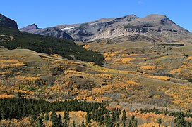
Mad Wolf Mountain is located in the Lewis Range of the Glacier National Park in the U.S. state of Montana.[3] Mad Wolf Mountain is just west of the Blackfeet Indian Reservation, and rises abruptly above the Great Plains. It stands at 8,341 feet, or 2,542 meters.
| Mad Wolf Mountain | |
|---|---|
 East aspect from Highway 49 | |
| Highest point | |
| Elevation | 8,341 ft (2,542 m)[1] |
| Prominence | 456 ft (139 m)[1] |
| Parent peak | Red Mountain[1] |
| Coordinates | 48°34′04″N 113°22′07″W[2] |
| Geography | |
| Location | Glacier County, Montana, U.S. |
| Parent range | Lewis Range |
| Topo map | USGS Cut Bank Pass, MT |
See also
References
- "Mad Wolf Mountain, Montana". Peakbagger.com. Retrieved December 26, 2018.
- "Mad Wolf Mountain". Geographic Names Information System. United States Geological Survey, United States Department of the Interior. Retrieved December 26, 2018.
- Kiowa, MT (Map). TopoQwest (United States Geological Survey Maps). Retrieved December 26, 2018.
Текст в блоке "Читать" взят с сайта "Википедия" и доступен по лицензии Creative Commons Attribution-ShareAlike; в отдельных случаях могут действовать дополнительные условия.
Другой контент может иметь иную лицензию. Перед использованием материалов сайта WikiSort.org внимательно изучите правила лицензирования конкретных элементов наполнения сайта.
Другой контент может иметь иную лицензию. Перед использованием материалов сайта WikiSort.org внимательно изучите правила лицензирования конкретных элементов наполнения сайта.
2019-2025
WikiSort.org - проект по пересортировке и дополнению контента Википедии
WikiSort.org - проект по пересортировке и дополнению контента Википедии

