geo.wikisort.org - Mountains
Ma Alalta is a stratovolcano in the Afar Region of Ethiopia, located well to the west of the Danakil Depression at the foot of the regional Ethiopian scarp. It has a summit elevation of 1,745 m (5,725 ft) and lies between two large horsts related to the East African Rift.[1]
| Ma Alalta | |
|---|---|
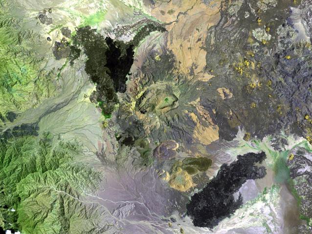 Satellite image of Ma Alalta (center) | |
| Highest point | |
| Elevation | 1,745 m (5,725 ft) |
| Listing | List of volcanoes in Ethiopia |
| Coordinates | 13.013°N 40.185°E |
| Geography | |
 Ma Alalta Afar Region, Ethiopia | |
| Geology | |
| Mountain type | Stratovolcano |
| Last eruption | Unknown |
Ma Alalta is trachytic and rhyolitic in composition, containing nested oval-shaped calderas at its summit. Extending northeast and southeast of the stratovolcano are ignimbrite deposits that may be related to the formation of a larger caldera in which Ma Alalta is located.[1]
The northwestern, southeastern and eastern flanks of Ma Alalta have produced youthful basaltic lava flows whereas the southern flank has produced recent pantelleritic obsidian domes and lava flows. One of the domes exhibit fumarolic activity.[1]
References
- "Ma Alalta". Global Volcanism Program. Smithsonian Institution. Retrieved 2021-06-16.
This article about a location in the Afar Region of Ethiopia is a stub. You can help Wikipedia by expanding it. |
На других языках
- [en] Ma Alalta
[fr] Ma Alalta
Le Ma Alalta est un volcan d'Éthiopie.Другой контент может иметь иную лицензию. Перед использованием материалов сайта WikiSort.org внимательно изучите правила лицензирования конкретных элементов наполнения сайта.
WikiSort.org - проект по пересортировке и дополнению контента Википедии