geo.wikisort.org - Mountains
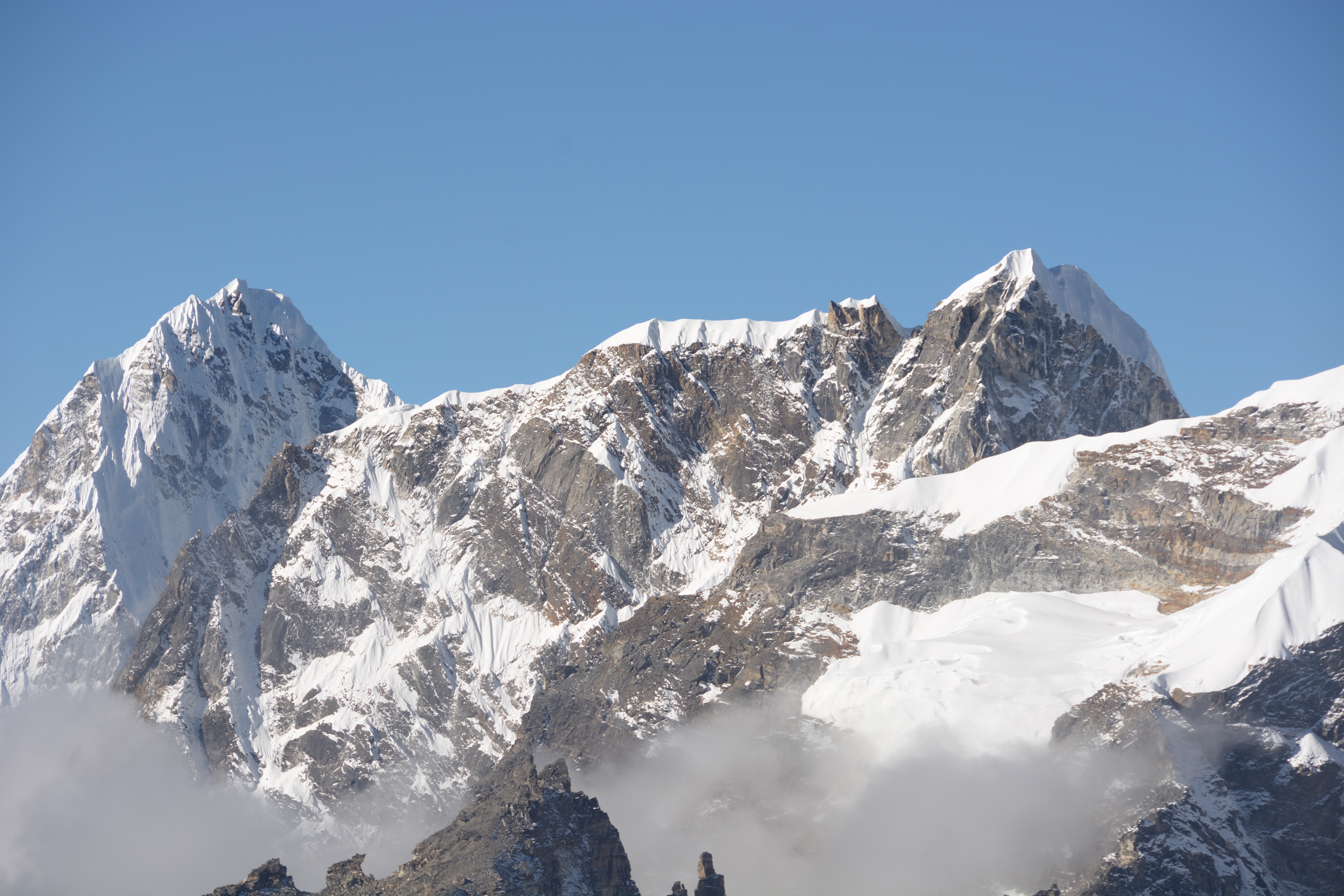
Lobuche (also spelt Lobuje) is a Nepalese mountain which lies close to the Khumbu Glacier and the settlement of Lobuche. There are two main peaks, Lobuche East and Lobuche West. A permit to climb the mountain is required from the Nepal Mountaineering Association (NMA), which classifies Lobuche East (6,119m) as a "trekking peak" and Lobuche West (6,145m) as an "expedition peak". As the easier, trekking peak, the East peak is climbed far more frequently than the West peak; however, most of those climbers only do so to a false summit a few hours from the true summit of Lobuche East. Between the two peaks is a long, deeply notched ridge, though a steep drop and considerable distance makes approaching the West peak from the East impossible.[2]
| Lobuche East | |
|---|---|
| Lobuje | |
 Lobuche East from the southeast | |
| Highest point | |
| Elevation | West: 6,145 m (20,161 ft) East: 6,119 m (20,075 ft)[1] |
| Prominence | 275 m (902 ft) |
| Coordinates | 27°57′34.2″N 86°47′23.8″E |
| Geography | |
 Lobuche East Location in Nepal | |
| Location | Khumbu, Nepal |
| Parent range | Himalayas |
| Climbing | |
| First ascent | April 25, 1984 |
| Easiest route | Scramble/Rock/Snow Climb |
The first recorded ascent of Lobuche East was made by Laurence Nielson and Sherpa Ang Gyalzen on April 25, 1984.[1]
Lobuje West was first climbed in 1955 via the South Shoulder.
Name Confusion
Many of the tourist operators offering treks and climbs to Lobuje refer to the two peaks as "Lobuche East" and "Lobuche Far East". The NMA - who own the mountain - however, refer to them as Lobuche West and Lobuche East.


Notable Ascents
In 1998, from September 29 to October 1, Slovenians Tomaž Humar and Janez Jeglič and Spaniard Carlos Carsolio climbed a new route on Lobuche East's northeast face in Alpine style. They named the route "Talking About Tsampa" (V-VI, 5.9, WI4, 85°, 900m).
Along the strikingly prominent southwestern pillar of Lobuche East, several routes have been completed. On a 1991 expedition, Eric Brand and Pemba Norbu used fixed ropes to climb the west pillar to the northwest summit (VI, 5.10, A3).[3] In 1995, Carlos Miguel and Eduard Sanchez also climbed the west pillar by a 6b+ route with one aid pitch.[3] They intersected with the Brand-Norbu route halfway up. In 2010, Americans Joel Kauffman and Jarad Vilhauer climbed a new route on the southwest face of Lobuje East (6119m) in Nepal's Khumbu region on October 30th. They established "Night Terrors" (VI, WI5+, AI4, M7, 85°) in a 37-hour push from advance base camp to the summit, and then descended to base camp via the normal route (south spur).
In 2010, Antonin Cecchini, Laurent Thévenot, Aurélien Vaissière, and Symon Welfringer arrived at Dzongla village and started climbing a route similar to the one used for the 1995 Spanish ascent (by Miguel-Miranda-Sanchez), which took them two long days to complete, after which they traversed from the true summit towards the false summit and then descended the mountain, reaching Dzongla by midnight (the descent took 5 and a half hours). They named the route "Le Quatuor à Cordes" (6b, A2, M4, 80°, 1,100m).[4]
References
- "Lobuje West". Nepal Mountaineering Association. Retrieved 4 October 2018.
- "NMA Peak Guide - Lobuje West". www.nepalmountaineering.org. Archived from the original on 28 May 2019. Retrieved 4 October 2018.
- Fortune, Steve (2019). "Lobuche East, Southwest Pillar, Hiding in Plain Sight". Climbs and Expeditions. American Alpine Journal. New Zealand: New Zealand Alpine Club. 61 (93): 323. Retrieved 27 November 2021.
- Welfringer, Symon (2019). "Lobuche East Southwest Pillar, Le Quatuor à Cordes". Climbs and Expeditions. American Alpine Journal. France: Himalayan Database. 61 (93): 0. Retrieved 27 November 2021.
На других языках
[de] Lobuche
Der Lobuche (auch: Lobuje) ist ein über sechstausend Meter hoher Berg in der Khumbu-Region in Nepal.- [en] Lobuche
[fr] Lobuche
Le Lobuche ou Lobuje est une montagne du Népal qui s'élève près du glacier du Khumbu. Elle culmine à 6 145 mètres d'altitude au pic oriental.[it] Lobuche
Lobuche (anche nota come Lobuje) è una montagna del Nepal molto vicina al Ghiacciaio Khumbu. Possiede due vette principali, Lobuche lontano est e Lobuche Est (spesso confuso con Lobuche Ovest che è un'altra montagna sita verso occidente). Alta 6.145 metri, il picco Lobuche Est è 26 metri più elevato. Tra i due picchi è una lunga cresta profondamente dentellata.[1][2][ru] Лобуче
Лобуче (англ. Lobuche, также пишется Lobuje) — гора в Гималаях высотой 6119 м над уровнем моря. Находится на территории Непала, в одноимённом поселении Лобуче, недалеко от ледника Кхумбу.Другой контент может иметь иную лицензию. Перед использованием материалов сайта WikiSort.org внимательно изучите правила лицензирования конкретных элементов наполнения сайта.
WikiSort.org - проект по пересортировке и дополнению контента Википедии