geo.wikisort.org - Mountains
The United States National Geodetic Survey lists 28 volcanic craters in the state of Arizona.
Coconino County

- Black Bottom Crater
- Campbell Crater
- Colton Crater
- Double Crater is an extinct Pleistocene volcano within the San Francisco volcanic field, north of Flagstaff.[1]
- Francis Crater
- Haywire Crater
- Junction Crater
- Lenox Crater
- Maroon Crater
- Merriam Crater
- Moon Crater
- North Sheba Crater
- O'Neill Crater
- Old Caves Crater
- Pinnacle Crater
- Rattlesnake Crater
- Robinson Crater was named for Henry H. Robinson, a United States Geological Survey researcher.[2]
- Roden Crater is an extinct volcano crater, and a project of artist James Turrell.[3]
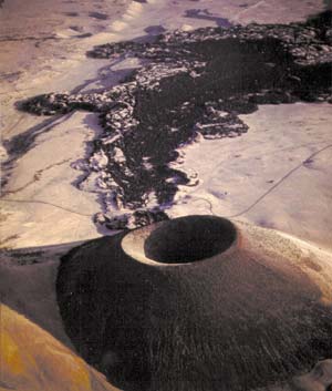
- S P Crater is a cinder cone volcano 25 miles (40 km) north of Flagstaff, Arizona.[4]
- Saddle Crater
- South Sheba Crater
- Stewart Crater
- Strawberry Crater
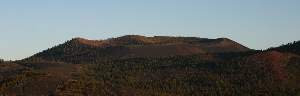
- Sunset Crater is a cinder cone volcano in the San Francisco volcanic field, and a part of the Sunset Crater National Monument.[5]
- The Sproul
Cochise County
- Paramore Crater
Greenlee County
- Mumphry's Peak
Located just northeast of the town of Clifton, Arizona, this dormant cinder cone volcano and crater is easily visible from the town and In the satellite view of Google Maps. The area is still geologically active, with several hot springs in the area.
See also
- Meteor Crater was created by the impact of a nickel-iron meteorite about 54 yards (49 m) across,[6] around 50,000 years ago.[7]
References
- Ulrich, G.E., Billingsley, G.H., Hereford, Richard, Wolfe, E.W., Nealey, L.D. and Sutton, R.L., 1984, Map showing geology, structure, and uranium deposits of the Flagstaff 1 degrees x 2 degrees quadrangle, Arizona: U.S. Geological Survey, Miscellaneous Investigations Series Map I-1446, scale 1:250000.
- USGS GNIS Feature Detail Report: Robinson Crater
- Finkel, Jori (2007-11-25). "Shh! It's a Secret Kind of Outside Art". The New York Times. Retrieved 2009-08-22.
- Susan S. Priest; Wendell A. Duffield; Karen Malis-Clark; James W. Hendley II; Peter H. Stauffer (2001-12-21). "The San Francisco Volcanic Field, Arizona: USGS Fact Sheet 017-01". United States Geological Survey. Retrieved 2008-09-02.
{{cite journal}}: Cite journal requires|journal=(help) - "Sunset Crater Volcano National Monument". National Park Service. 2007-09-14. Retrieved 2008-08-12.
- Melosh HJ, Collins GS (2005). "Planetary science: Meteor Crater formed by low-velocity impact". Nature. 434 (7030): 157. Bibcode:2005Natur.434..157M. doi:10.1038/434157a. PMID 15758988.
- Roddy, D. J.; E. M. Shoemaker (1995). "Meteor Crater (Barringer Meteorite Crater), Arizona: summary of impact conditions". Meteoritics. 30 (5): 567.
Текст в блоке "Читать" взят с сайта "Википедия" и доступен по лицензии Creative Commons Attribution-ShareAlike; в отдельных случаях могут действовать дополнительные условия.
Другой контент может иметь иную лицензию. Перед использованием материалов сайта WikiSort.org внимательно изучите правила лицензирования конкретных элементов наполнения сайта.
Другой контент может иметь иную лицензию. Перед использованием материалов сайта WikiSort.org внимательно изучите правила лицензирования конкретных элементов наполнения сайта.
2019-2025
WikiSort.org - проект по пересортировке и дополнению контента Википедии
WikiSort.org - проект по пересортировке и дополнению контента Википедии