geo.wikisort.org - Mountains
The Lebombo Mountains, also called Lubombo Mountains (Portuguese: Montes Libombos), are an 800 km-long (500 mi), narrow range of mountains in Southern Africa. They stretch from Hluhluwe in KwaZulu-Natal in the south to Punda Maria in the Limpopo Province in South Africa in the north. Parts of the mountain range are also found in Mozambique and Eswatini.
| Lebombo Mountains | |
|---|---|
| (Lubombo / Libombos) | |
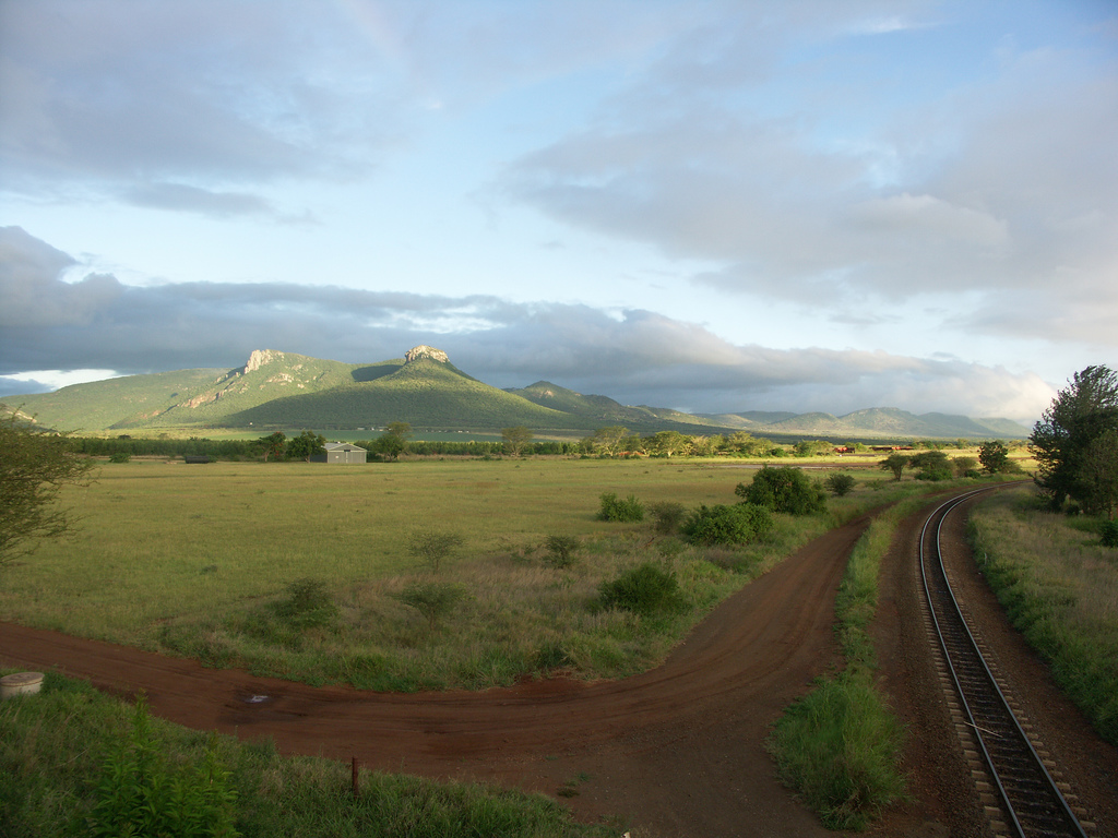 Part of the Lebombo mountain chain, including Ghost Mountain; seen from Mkuze | |
| Highest point | |
| Peak | Mount Mananga |
| Elevation | 776 m (2,546 ft) |
| Listing | List of mountain ranges of South Africa |
| Coordinates | 26°15′0″S 32°0′0″E |
| Dimensions | |
| Length | 800 km (500 mi) N/S |
| Width | 100 km (62 mi) E/W |
| Geography | |
 Lebombo Mountains | |
| Countries | Mozambique, South Africa and Eswatini |
| Geology | |
| Orogeny | Gondwanian |
| Age of rock | Precambrian |
| Type of rock | Rhyolite and basalt |
Description
This section needs additional citations for verification. (August 2022) |
Geologically, the range is considered a monocline; part of a rifted volcanic margin.[1] The Lebombo monocline was aligned with the Explora Escarpment off-shore Dronning Maud Land, Antarctica, before the break-up of Gondwana.[2] The Lebombo monocline strikes N-S and dips to the east. It is composed of a sequence of Jurassic age volcanic rock, both basaltic lavas and rhyolitic flows and tuffs. The sequence rests on essentially horizontal Karoo Supergroup sedimentary rocks of the Kalahari Craton to the west and is overlain by Cretaceous to recent sediments to the east. The alternating resistant rhyolite and easily eroded basalts produce a series of parallel sharp cuesta ridges separated by savanna plains.[3]
The range is relatively low with heights between 400 m (1,300 ft) and less than 800 m (2,600 ft). The highest peak is the 776 m-high (2,546 ft) Mount Mananga. The 480 m-high (1,570 ft) Longwe is the highest point in the Lebombo Range north of the Letaba River.[4]
The mountains dominate Lubombo District in Eswatini. Towns in the area include Siteki in the centre, Lubhuku in the west and Mayaluka and Big Bend in the south with the Lusutfu River running past the southern region of the mountain range. At the north lie the towns of Simunye, Tambankulu and Namaacha, and the Mlawula Nature Reserve as well as the Mbuluzi River.
A number of rivers, including the Pongola, Mkuze, and Lusutfu, cross the mountains from west to east.
The name of the mountains is derived from the Zulu word ubombo meaning "big nose".
Protected areas
Kruger National Park and Phongolo Nature Reserve protect part of the range.
See also
- Explora Escarpment - an escarpment off the coast of Antarctica which was aligned with the mountains before the breakup of Gondwana.
References
- Watkeys, M.K. (2002). "Development of the Lebombo rifted volcanic margin of southeast Africa". GSA Special Papers. Geological Society of America. 362. doi:10.1130/0-8137-2362-0.27. ISBN 9780813723624.
- Jokat, W.; Boebel, T.; König, M.; Meyer, U. (2003). "Timing and geometry of early Gondwana breakup". Journal of Geophysical Research: Solid Earth. 108 (B9). doi:10.1029/2002JB001802. Retrieved 30 July 2016.
- Manninen, Tuomo, et al., The Karoo Volcanic Rocks and Related Intrusions in Southern and Central Mozambique, Geological Survey of Finland, 2008, Special Paper 48, pp. 211–250
- Echo System
External links
This Mozambique location article is a stub. You can help Wikipedia by expanding it. |
This South Africa location article is a stub. You can help Wikipedia by expanding it. |
This Eswatini location article is a stub. You can help Wikipedia by expanding it. |
На других языках
[de] Lebomboberge
Die Lebomboberge (auch Lubomboberge, von ubombo (isiZulu), dt. „Große Nase“) sind eine sich über die Distanz von etwa 600 Kilometern[1] erstreckende, schmale Kette von gebirgigen und hügeligen Erhebungen im südlichen Afrika.- [en] Lebombo Mountains
[es] Cordillera Lebombo
La cordillera de Lebombo se extiende desde Hluhluwe en la Provincia de KwaZulu-Natal en Sudáfrica hasta el sur de Punda María en la Provincia de Limpopo, también en Sudáfrica a lo largo de unos 800 km. Atraviesa Suazilandia de norte a sur por su extremo oriental dando nombre al Distrito de Lubombo y se extiende también por el sudoeste de Mozambique.[fr] Monts Lebombo
Les monts Lebombo, appelées également montagnes Lubombo, forment une chaîne de montagnes de 800 km de long en Afrique du Sud, en Eswatini et au Mozambique.[it] Monti Lebombo
I Monti Lebombo o Lubombo sono una lunga e stretta catena montuosa di modesta altitudine dell'Africa sud-orientale. Si estendono per circa 800 km in direzione nord-sud e sono composti da rocce vulcaniche. L'altitudine media è di circa 600 metri sopra il livello del mare; il punto più alto è il Monte Mananga al confine tra la provincia di Mpumalanga e lo Swaziland che arriva a circa 760 metri. Il nome deriva dalla parola Zulu, Ubombo, che significa "grande naso".[ru] Лебомбо
Лебомбо — узкая горная цепь длиной 800 км, тянущаяся от города Хлухлуве в провинции Квазулу-Наталь на юге до Пунда-Мария в провинции Лимпопо в ЮАР на севере. Некоторые участки горной цепи расположены не только в Южной Африке, но и также в Мозамбике и Эсватини.Другой контент может иметь иную лицензию. Перед использованием материалов сайта WikiSort.org внимательно изучите правила лицензирования конкретных элементов наполнения сайта.
WikiSort.org - проект по пересортировке и дополнению контента Википедии