geo.wikisort.org - Mountains
The Kular Range (Russian: хребет Кулар, Khrebet Kular; Yakut: Кулар сис, Kular Sis) is a range of mountains in far North-eastern Russia. Administratively the range is part of the Eveno-Bytantaysky National District of the Sakha Republic, Russian Federation.[1]
| Kular Range | |
|---|---|
| хребет Кулар / Кулар сис | |
 Kular Range Location in the Sakha Republic, Russia | |
| Highest point | |
| Peak | Unnamed |
| Elevation | 1,289 m (4,229 ft) |
| Coordinates | 68°54′N 131°53′E |
| Dimensions | |
| Length | 380 km (240 mi) NE / SW |
| Geography | |
| Location | Sakha Republic, Far Eastern Federal District |
| Parent range | Verkhoyansk Range, East Siberian System |
| Geology | |
| Type of rock | Shale, sandstone and Granite intrusions (North) |
This range is one of the places in Yakutia where yedoma are found.[2]
Geography
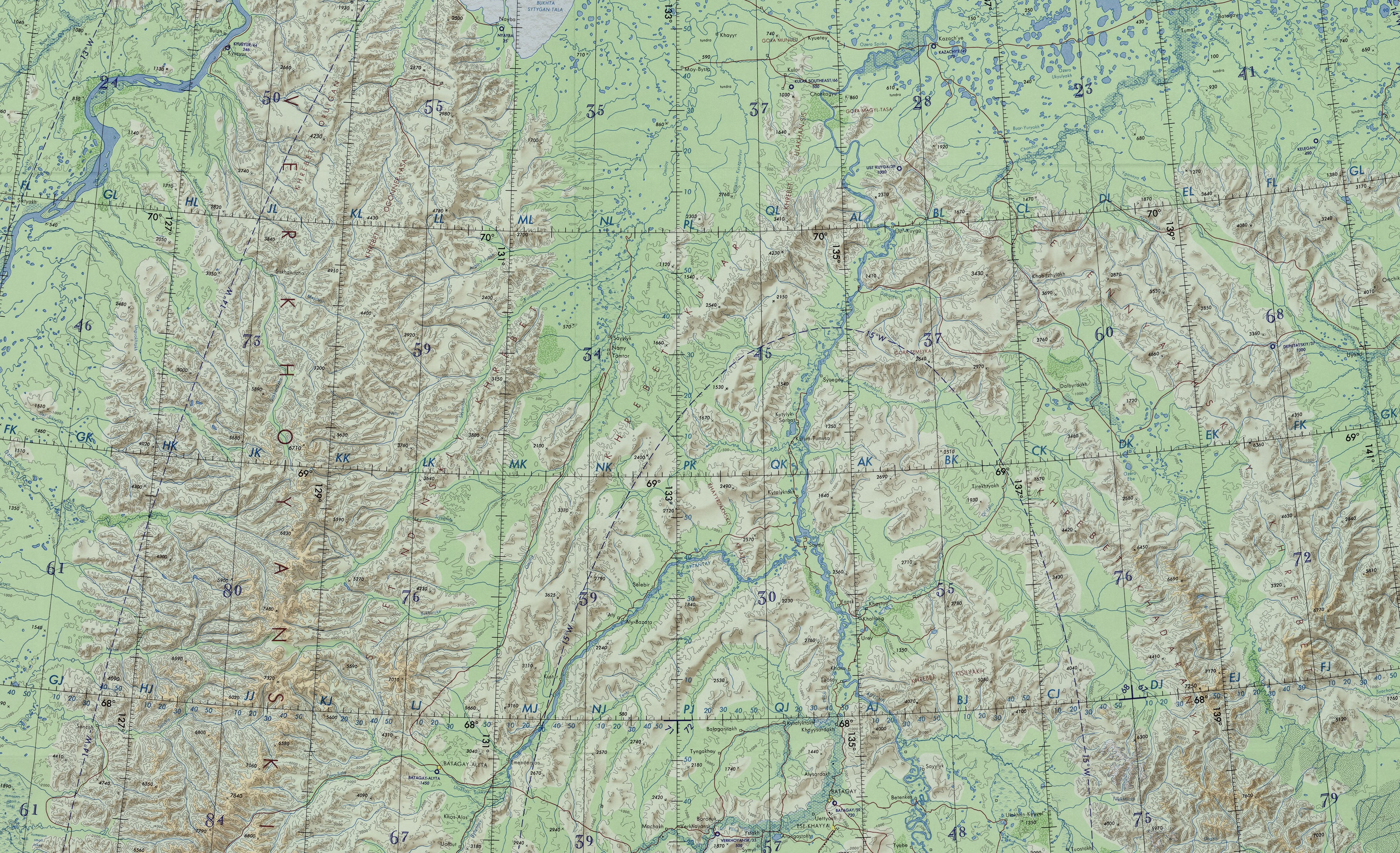
The Kular Range extends in an arch north of Batagay-Alyta to the NE for about 380 kilometres (240 mi), west and NW of the Bytantay River and west of the Yana, after it joins that great river. In the northeast rise the Kyundyulyun mountains, a prolongation beyond the Yana River and to the southeast the Yana Plateau. The highest point of the Kular Range is an unnamed 1,289 metres (4,229 ft) high summit.[1]
It is one of the main subranges of the Verkhoyansk Range system. To the west it is limited by the Omoloy River valley, beyond which rises the Sietinden Range, which runs in a parallel direction. The range is deeply cut by wide riverine intermontane basins in its middle part. Rivers Baky and Ulakhan-Kyuegyulyur have their source in the range. The Yana-Indigirka Lowland lies to the northeast.[3]
Ulakhan Sis Range
Near the northern end of the Kular Range, at 70°23′46.2″N 134°22′37.95″E —about 440 kilometres (270 mi) north of the Arctic Circle, there is a branch of the main range running northwards named Ulakhan Sis. It is about 100 kilometres (62 mi) long and its highest point is 496 metres (1,627 ft). The Yana River meanders northwards east of the Ulakhan Sis Range and beyond it rises the Magyl-Tasa Massif.[4]
Khayrdakh Ridge
The Khayrdakh Ridge (Russian: Хайырдахский кряж Yakut: Хайыырдаах томтороот) is a smaller subrange of the Kular Range located between the lower course of the Bytantay and the Baky.[3]
Flora
The mountains are covered with mountain tundra and in the valleys with larch forests and tundra.[1]
References
- Kular (mountains) / Great Soviet Encyclopedia; in 35 vols. / Ch. ed. Yu. S. Osipov. 2004—2017.
- Vasil'chuk Y.K., Budantseva N.A., Vasil'chuk J.Y. , Heavy metals and trace elements in the Late Pleistocene ice-wedge casts of Northern Yakutia/ Arctic and Antarctica. – 2017. – № 1. – P. 23
- "R-53_54 Topographic Chart (in Russian)". Retrieved 17 May 2022.
- Google Earth
This Sakha Republic location article is a stub. You can help Wikipedia by expanding it. |
На других языках
[de] Kulargebirge
Der Kulargebirge (russisch Горы Кулар, jakutisch Кулар сис), auch Kularkamm (Хребет Кулар) genannt, ist eine bis 1302 m[1][2] hohe, etwa 380 km[3] lange Gebirgskette des Ostsibirischen Berglands, jeweils im Nordosten der Republik Sacha (Jakutien) sowie von Sibirien und Russland (Asien).- [en] Kular Range
[it] Monti Kular
I monti Kular (in russo: Кулар хребет?) sono una catena montuosa nell'estremo nord-est siberiano che fa parte del sistema montuoso dei monti di Verchojansk. Si trovano nell'Ėveno-Bytantajskij ulus della Sacha (Jacuzia), in Russia.[ru] Кулар (хребет)
Кула́р — горный хребет на севере Якутии, в Эвено-Бытантайском национальном улусе.Другой контент может иметь иную лицензию. Перед использованием материалов сайта WikiSort.org внимательно изучите правила лицензирования конкретных элементов наполнения сайта.
WikiSort.org - проект по пересортировке и дополнению контента Википедии