geo.wikisort.org - Mountains
Koh e Alburz, Romanized as Kuh i Elburz, Gory Koh-i-Elburz, Kohe Alborz, Kuh i Alborz (Dari: کوه البرز high mountain) is a mountain a ridge of the Hindu Kush in Afghanistan, Balkh Province. The ridge is elongated to the south of the ancient city of Balkh, which is about 25 kilometers northwest from the city of Mazar-i-Sharif. It is a tertiary, elongated ridge with steep slopes to the north and south. The comb has short canyons. Between the breaking points are the small river Schadyan and Marmal mountain. The German ISAF troops call their nearby military camp Camp Marmal.
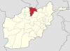
Balkh Province | ||
|---|---|---|
Capital: Balkh | ||
| Districts |
|  |
| Landforms |
| |
| Landmarks and culture |
| |
This article does not cite any sources. (September 2020) |
| Koh e Alburz | |
|---|---|
| (Dari: کوه البرز) | |
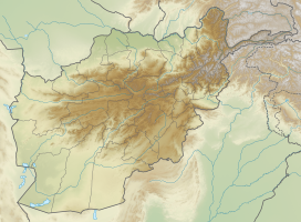 Koh e Alburz Location in the Hindu Kush | |
| Highest point | |
| Elevation | 1,032 m (3,386 ft) |
| Parent peak | Hindu Kush |
| Coordinates | 36°34′12″N 66°52′12″E |
| Geography | |
| Location | Balkh Province |
| Parent range | Hindu Kush |
На других языках
[de] Koh-i-Elburz
Der Koh-i-Elburz (auch Gory Al'burz, Koh-i-Alburz, Kohe Alburz, Kuh-e Alborz, Kuh-i Elburz, Kūh-e Alborz, Kūh-i Elburz,[1] persisch کوه البرز Alborz-Berg) ist ein Gebirgskamm in der afghanischen Provinz Balch. Der Bergrücken erstreckt sich südlich des Ortes Balch, der etwa 20 Kilometer nordwestlich von Mazār-i Scharif liegt. Es handelt sich hierbei um einen tertiären, langgezogenen Kamm, mit steilen Flanken nach Norden und Süden. Die Kette wird durch kurze Schluchten unterbrochen, die von den Bächen Schadyan und Marmol eingeschnitten wurden.[2][3]- [en] Koh e Alburz (Balkh)
Текст в блоке "Читать" взят с сайта "Википедия" и доступен по лицензии Creative Commons Attribution-ShareAlike; в отдельных случаях могут действовать дополнительные условия.
Другой контент может иметь иную лицензию. Перед использованием материалов сайта WikiSort.org внимательно изучите правила лицензирования конкретных элементов наполнения сайта.
Другой контент может иметь иную лицензию. Перед использованием материалов сайта WikiSort.org внимательно изучите правила лицензирования конкретных элементов наполнения сайта.
2019-2025
WikiSort.org - проект по пересортировке и дополнению контента Википедии
WikiSort.org - проект по пересортировке и дополнению контента Википедии