geo.wikisort.org - Mountains
Kalurong or Kalaxung is a mountain located in the Tibet Autonomous Region of China. It is a part of Lhagoi Kangri belt, which is a heteroclite juxtaposition of subranges that is compressed between the Yarlung Tsangpo (Brahmaputra River) river to the north and the Assam Himalaya to the south.
| Kalurong | |
|---|---|
 Kalurong in Central Tibet, 26 September 2014 | |
| Highest point | |
| Elevation | 6,674 m (21,896 ft) |
| Prominence | 1,548 m (5,079 ft) |
| Coordinates | 28°50′13″N 90°13′10″E |
| Geography | |
 Kalurong Location in Tibet 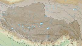 Kalurong Kalurong (Tibet) | |
| Location | Tibet/China |
| Climbing | |
| First ascent | No Records |
Location
The mountain has two summits — Kalurong North, which is located at 6,674 m (21,896 ft)[1] above sea level and Kalurong South, which is located at 6,536 m (21,444 ft). The superstructure of the mountain is in Central Tibet, south of the Karo La pass. Both the summits are connected through a saddle at 6,314 m (20,715 ft).[2]
Climbing history
In September of 2005, a Japanese expedition led by the Keio University Alpine Club made the mountain's first ascent.[2]
References
- "Kalurong - Peakbagger.com". www.peakbagger.com. Retrieved 2022-05-25.
- "Kaluxung / Kalurong 6674m : Climbing, Hiking & Mountaineering : SummitPost". www.summitpost.org. Retrieved 2022-05-25.
На других языках
[de] Kalurong
Der Kalurong (auch Kaluxung) ist ein Berg im autonomen Gebiet Tibet.- [en] Kalurong
Текст в блоке "Читать" взят с сайта "Википедия" и доступен по лицензии Creative Commons Attribution-ShareAlike; в отдельных случаях могут действовать дополнительные условия.
Другой контент может иметь иную лицензию. Перед использованием материалов сайта WikiSort.org внимательно изучите правила лицензирования конкретных элементов наполнения сайта.
Другой контент может иметь иную лицензию. Перед использованием материалов сайта WikiSort.org внимательно изучите правила лицензирования конкретных элементов наполнения сайта.
2019-2026
WikiSort.org - проект по пересортировке и дополнению контента Википедии
WikiSort.org - проект по пересортировке и дополнению контента Википедии