geo.wikisort.org - Mountains
Kaliva Range (Bulgarian: хребет Калива, ‘Hrebet Kaliva’ \'hre-bet ka-'li-va\ is the mostly ice-covered range extending 24.7 km in southeast-northwest direction and 10 km wide, rising to 1771 m[1] (Mount Ader) in the northwest foothills of Detroit Plateau and partly on Chavdar Peninsula, on the border between Davis Coast and Danco Coast in Graham Land, Antarctica. It is separated from Lale Buttress on the southeast by Sinitovo Gap, and surmounts Breguet Glacier to the south, Gregory Glacier to the southwest, Tumba, Samodiva and Pirin Glaciers to the north, and Wright Ice Piedmont to the northeast.
The range is named after the ancient fortress of Kaliva in Southeastern Bulgaria.
Location
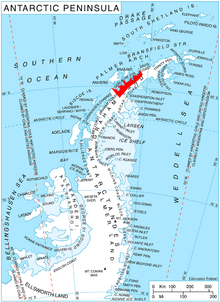
Kaliva Range is centred at 64°08′20″S 60°40′30″W. British mapping in 1978.
Maps
- British Antarctic Territory. Scale 1:200000 topographic map. DOS 610 Series, Sheet W 64 60. Directorate of Overseas Surveys, Tolworth, UK, 1978.
- Antarctic Digital Database (ADD). Scale 1:250000 topographic map of Antarctica. Scientific Committee on Antarctic Research (SCAR). Since 1993, regularly upgraded and updated.
Notes
- Reference Elevation Model of Antarctica. Polar Geospatial Center. University of Minnesota, 2019
References
- Bulgarian Antarctic Gazetteer. Antarctic Place-names Commission. (details in Bulgarian, basic data in English)
- Kaliva Range. SCAR Composite Gazetteer of Antarctica.
External links
Kaliva Range. Copernix satellite image
This article includes information from the Antarctic Place-names Commission of Bulgaria which is used with permission.
This Danco Coast location article is a stub. You can help Wikipedia by expanding it. |
На других языках
[de] Kaliva Range
Die Kaliva Range (englisch; bulgarisch Хребет Калива .mw-parser-output .Latn{font-family:"Akzidenz Grotesk","Arial","Avant Garde Gothic","Calibri","Futura","Geneva","Gill Sans","Helvetica","Lucida Grande","Lucida Sans Unicode","Lucida Grande","Stone Sans","Tahoma","Trebuchet","Univers","Verdana"}Chrebet Kaliva) ist ein größtenteils vereistes, in südost-nordwestlicher Ausrichtung 24,7 km langes, 10 km breites und bis zu 1600 m hohes Gebirge in den nordwestlichen Ausläufern des Detroit-Plateaus an der Grenze zwischen Danco- und Davis-Küste des Grahamlands auf der Antarktischen Halbinsel. Es ragt teilweise auf der Tschawdar-Halbinsel auf und ist über das Sinitovo Gap nach Südosten mit dem Perkos Dome verbunden. Der Breguet-Gletscher liegt südlich, der Gregory-Gletscher südwestlich. Nach Norden schließen sich die Tumba-Eiskappe, der Samodiwa- und der Pirin-Gletscher an, nach Nordosten der Wright-Piedmont-Gletscher.- [en] Kaliva Range
Другой контент может иметь иную лицензию. Перед использованием материалов сайта WikiSort.org внимательно изучите правила лицензирования конкретных элементов наполнения сайта.
WikiSort.org - проект по пересортировке и дополнению контента Википедии