geo.wikisort.org - Coast
The Danco Coast (64°42′S 62°0′W) is the portion of the west coast of the Antarctic Peninsula between Cape Sterneck and Cape Renard. This coast was explored in January and February 1898 by the Belgian Antarctic Expedition under Adrien de Gerlache, who named it for Lieutenant Emile Danco who died on the expedition.[1]
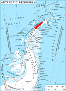
The coast is bordered by the Aguirre Passage which separates it from Lemaire Island.[2]

Places on the Danco Coast
- Brabazon Point
- Salvesen Cove
Geology
The Danco Coast Tectonic Block includes the Upper Permian-Triassic Trinity Peninsula Group, consisting of over 1000 m of metaturbidites folded during the Gondwanide orogeny. This group is overlain by the Lower Cretaceous Antarctic Peninsula Volcanic Group, with up to 2000 m of basaltic and andesitic lavas, tuffs and agglomerates, which were folded and faulted during the Tertiary. These two groups were intruded by the Berriasian-Cenomanian granite and gabbro sills of the Andean Instrusive Suite. A system of hypabbysal dykes intruded during the Late Cretaceous or Tertiary.[3]
See also
- Gerlache Strait Geology
- Mount Frödin
Further reading
- R. Casaux, M. L. Bertolin, A. Carlini, Feeding habits of three seal species at the Danco Coast,Antarctica: a re-assessment, Polar Biol (2011) 34:1615–1620, DOI 10.1007/s00300-011-0994-1
References
 This article incorporates public domain material from the United States Geological Survey document: "Danco Coast". (content from the Geographic Names Information System)
- "Things to do in The Danco Coast - Travel Guides - Holland America Line". destinationguides.hollandamerica.com. Retrieved 2017-09-18.
- This article incorporates public domain material from the United States Geological Survey document: "Aguirre Passage". (content from the Geographic Names Information System)
- Birkenmajer, Krzysztof (1999). The Tectonic Structure of Gerlache Strait, West Antarctica, in Polish Polar Studies XXVI Polar Symposium (PDF). Lublin: Polish Polar Studies. pp. 45–50. Retrieved 3 January 2020.
This Danco Coast location article is a stub. You can help Wikipedia by expanding it. |
На других языках
- [en] Danco Coast
[it] Costa di Danco
La costa di Danco (centrata alle coordinate .mw-parser-output .geo-default,.mw-parser-output .geo-dms,.mw-parser-output .geo-dec{display:inline}.mw-parser-output .geo-nondefault,.mw-parser-output .geo-multi-punct{display:none}.mw-parser-output .latitude,.mw-parser-output .longitude{white-space:nowrap}.mw-parser-output .geo{}body.skin-vector .mw-parser-output #coordinates{font-size:85%;line-height:1.5em;position:absolute;right:0;top:0;white-space:nowrap}64°42′S 62°00′W) è una porzione della costa della Terra di Graham, in Antartide. In particolare, la costa di Danco si estende nella parte occidentale della penisola Antartica tra capo Sterneck, a nordest, e capo Renard, a sudovest, confinando quindi a nordest con la costa di Davis e a sudovest con la costa di Graham.[1]Другой контент может иметь иную лицензию. Перед использованием материалов сайта WikiSort.org внимательно изучите правила лицензирования конкретных элементов наполнения сайта.
WikiSort.org - проект по пересортировке и дополнению контента Википедии