geo.wikisort.org - Mountains
The Hocking Hills is a deeply dissected area of the Allegheny Plateau in Ohio, primarily in Hocking County, that features cliffs, gorges, rock shelters, and waterfalls. The relatively extreme topography in this area is due to the Blackhand Sandstone (so named because of Native American graphics on the formation near Newark, Ohio), a particular formation that is thick, hard and weather-resistant, and so forms high cliffs and narrow, deep gorges.

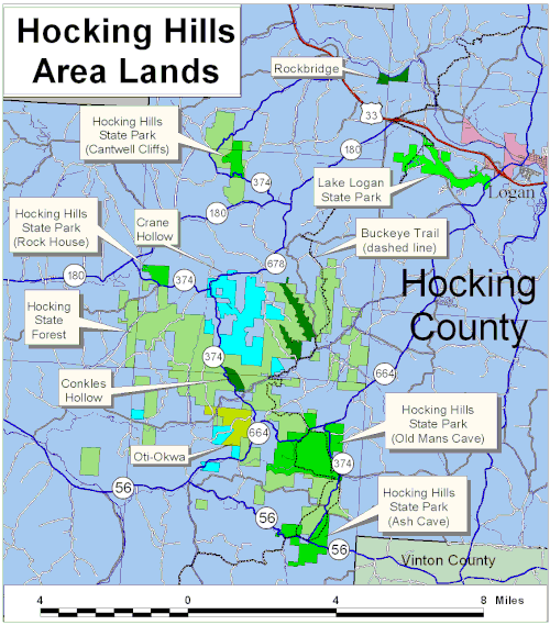
Component open-space areas
Most of the more scenic areas of the region are under state ownership, including:
- Hocking Hills State Park (with five use areas: Ash Cave, Cedar Falls, Old Man's Cave, Rockhouse, and Cantwell Cliffs)
- Hocking State Forest
- Conkle's Hollow State Nature Preserve
- Sheick Hollow State Nature Preserve (entry by permit only)
- Little Rocky Hollow State Nature Preserve (entry by permit only)
- Kessler Swamp State Nature Preserve
- Lake Logan State Park
- Wayne National Forest
- Rockbridge State Nature Preserve
The core area also includes two privately owned preserves, Crane Hollow and Camp Oty-Okwa (owned by Big Brothers and Big Sisters of Central Ohio).
The geological series that forms the Hocking Hills extends south and west, gradually diminishing but still forming impressive bluffs and gorges in:
- Clear Creek Metro Park, part of the Columbus and Franklin County Metropolitan Park District
- Rising Park in Lancaster
- Wahkeena Memorial State Nature Preserve in Fairfield County
- Christmas Rocks State Nature Preserve in Fairfield County
- Rhododendron Cove State Nature Preserve in Fairfield County
- Shallenberger State Nature Preserve in Fairfield County
- Saltpetre Cave State Nature Preserve in Hocking County
- Boch Hollow State Nature Preserve (exposure is along the westernmost edge only) in Hocking County
- Lake Katharine State Nature Preserve in Jackson County
- Blackhand Gorge State Nature Preserve in Licking County
- Liberty Wildlife Area in Jackson County
The Buckeye Trail, along with the North Country Trail and the American Discovery Trail, passes through the Hocking Hills region.
Also nearby are:
- Lake Hope State Park
- Zaleski State Forest
- Camp Wyandot
- Tar Hollow State Park
- Tar Hollow State Forest
- Camp Akita (UCC church camp)
Climate
The region has mild weather with an average rainfall of 40.3 inches per year and an average of about 175 sunny days per year. The average July high is 84.8 degrees Fahrenheit and the average January low is 19.3 degrees Fahrenheit.[1]
| Climate | Hocking Hills | United States |
|---|---|---|
| Rainfall (in.) | 40.3 | 36.5 |
| Snowfall (in.) | 18.2 | 25 |
| Precipitation days | 110 | 100 |
| Sunny days | 175 | 2-5 |
| Avg. July high | 84.8 | 86.5 |
| Avg. Jan. low | 19.3 | 20.5 |
| Comfort index (higher=better) | 46 | 44 |
| UV index | 5.2 | 4.3 |
| Elevation (ft.) | 776 | 1,060 |
History
The region was first settled by Christian Eby and was named from a shortened version of the Hockhocking River by the Shawnee Indian tribe. "Hockhocking", in the Delaware tongue, signifies a bottle. The Shawnee people thought that a very narrow and straight creek above the waterfall on the Hockhocking River resembled a bottle's neck.
Other notable settlers were George Starkey and Moses Dolson. The first election on county matters was held in Eby's mill near Queer Creek. The first post office in the area was called the "Rockhouse" and was located in Herschel Badford's home.[2]
Hocking County formation
Hocking County was formed on March 1, 1818, from Ross, Athens, Fairfield and Logan. The county's boundaries and townships have not been altered since 1851. Due to its natural surroundings, it has become a tourist attraction.[3]
Outdoor activities
Visitors can experience Hocking Hills through outdoor activities year round, including farmers' markets, wine tastings and train rides. Activities include:
- Athens Farmers Market
- Earth, Water, Rock: Outdoor Adventures
- Hocking Hills Canopy Tours (late March through the last weekend in November)
- Happy Hills Fun Park
- Hocking Hills Gem Mine
- Hocking Hills Marina at Lake Logan[4]
- Hocking Hills Primal Trek
- Hocking Hills Adventures
- Hocking Peaks
- Hocking Valley Scenic Railway
- Hunting at Hocking Hills Cabins
- Shade Winery
- Sharp Farms Pumpkins & Corn Maze
- The Buckeye Trail
- Touch the Earth Adventures
- Valley Zipline Tours Walker Farm
- Wayne National Forest
- Nelsonville's Historic Public Square
Hiking trails
Hocking County offers miles of trails that vary in length and difficulty depending on location. Some trails are pet friendly.[5]
- Old Man's Cave: 1 mile
- Ash Cave Gorge: ¼ mile, wheelchair accessible
- Ash Cave Rim: ½ mile
- Cedar Falls: ½ mile
- Rock House: 1 mile
- Cantwell Cliffs: various trails, around 3 miles
- Conkle's Hollow: 1 mile, wheelchair accessible
- Conkle's Hollow Rim: 2½ miles
- Buckeye Trail: Cedar Falls – Ash Cave: 3 miles, Old Man's Cave – Cedar Falls: 3 mile; also over 1,400 other miles around the state of Ohio, coincident with the North Country Trail and the American Discovery Trail in the Hocking Hills area.
Rare plants
The Hocking Hills area harbors a number of rare plants, including Huperzia porophila, the rock firmoss; Botrychium simplex, the least grape fern; Silene rotundifolia, the round-leaf catchfly, and Trichomanes boschianum, the Appalachian filmy fern.
See also
- Appalachian Ohio
- Ohio public lands
References
- "Climate in Hocking County, Ohio". Sperling's.
- "Hocking County Name". 1800hocking.com. Archived from the original on 2012-08-06. Retrieved 2012-08-19.
- "Hocking County History". 1800hocking.com. Archived from the original on 2012-08-06. Retrieved 2012-08-19.
- Hocking Hills Marina at Lake Logan
- "Bring Your Pets to Hocking Hills For Some Four-Legged Fun". Hocking Hills Tourism Association. Archived from the original on 2012-02-11. Retrieved 2012-06-24.
External links
| Wikivoyage has a travel guide for Hocking Hills. |
- Hocking Hills at American Byways
- Hocking Hills State Park
- Hocking Hills Official Website
- Hocking Hills Tourism Association
- Hocking Hills Tourism Website
- Hocking Hills tourist information and maps
| Authority control: National libraries |
|---|
Другой контент может иметь иную лицензию. Перед использованием материалов сайта WikiSort.org внимательно изучите правила лицензирования конкретных элементов наполнения сайта.
WikiSort.org - проект по пересортировке и дополнению контента Википедии