geo.wikisort.org - Mountains
Hartmannswillerkopf, also known as the Vieil Armand (French) or Hartmannsweiler Kopf (German; English: Hartmansweiler Head) is a pyramidal rocky spur in the Vosges mountains of the Grand Est region, France. The peak stands at 956 metres (3,136 ft) overlooking the Rhine valley. At Hartmannswillerkopf stands a national monument of World War I for the fighting which took place in the trenches here.
| Hartmannswillerbein | |
|---|---|
| Vieil Armand | |
 The Hartmannswillerkopf seen from the Molkenrain | |
| Highest point | |
| Elevation | 696 m (2,283 ft)[1] |
| Coordinates | 47°51′40″N 7°09′40″E |
| Naming | |
| English translation | Old Armand |
| Language of name | French |
| Geography | |
 Hartmannswillerbein Haut-Rhin, Alsace,  Hartmannswillerbein Hartmannswillerbein (France) | |
| Parent range | Vosges Mountains |
Mountain peak
The peak is located 6 kilometres (3.7 mi) from Cernay and 17 kilometres (11 mi) north-west of Mulhouse. The mountain is shared by the towns of Hartmannswiller, Wuenheim, Wattwiller and Uffholtz.
Battle
The French and Germans fought for control of the mountain peak during the First World War. Fighting took place throughout 1915. An estimated 25,000 French soldiers died there.[2] After about 11 months of fierce combat, both sides began to focus most of their attention farther north on the Western Front. Only enough men to hold the lines were left at Hartmannswillerkopf. The lines remained relatively stable for the remainder of the war and generally only artillery exchanges took place.
National monument
| Hartmannswillerkopf | |
|---|---|
| France | |
 The memorial at Hartmannswillerkopf | |
| For World War I battles at Hartmannswillerkopf | |
| Location | 47°51′32″N 7°9′0″E |
Today, the area is a French national monument. There is a museum and a cemetery at the site, and it is also possible to explore the extensive trench system. Because the lines were static for such a long period, the trenches are very well preserved, especially on the German side of the front line.
There is a small memorial on the D431 north of Vieil Armand, commemorating Halifax bomber MZ807 of No. 433 Squadron RCAF, which crashed nearby in December 1944.
On 3 August 2014, French President Francois Hollande and German President Joachim Gauck together marked the centenary of Germany's declaration of war on France by laying the first stone of a memorial at Hartmannswillerkopf, for French and German soldiers killed in this area during the war.[3] On 10 November 2017 French President Emmanuel Macron and German President Frank-Walter Steinmeier inaugurated the new memorial.[4]
Gallery
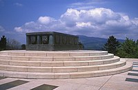 The national Monument
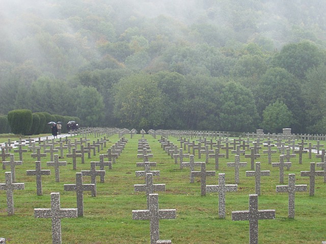
 Hartmannswillerkopf cemetery
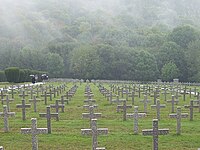 Hartmannswillerkopf cemetery
![Monument to General Marcel Serret [fr]](//upload.wikimedia.org/wikipedia/commons/thumb/7/71/2008_05_30_HWK-Monument_Serret.JPG/150px-2008_05_30_HWK-Monument_Serret.JPG) Monument to General Marcel Serret
Monument to General Marcel Serret


![Monument to General Marcel Serret [fr]](http://upload.wikimedia.org/wikipedia/commons/7/71/2008_05_30_HWK-Monument_Serret.JPG)
References
- IGN maps available on Géoportail
- Le Hartmannswillerkopf (68)
- "French, German Presidents Mark World War I Anniversary". France News.Net. Archived from the original on 10 October 2014. Retrieved 3 August 2014.
- "France & Germany open new WWI memorial". Euronews. Retrieved 10 November 2014.
External links
- official website of the National Monument of the Hartmannswillerkopf (English)
- The Memorial Centre in Uffholtz (French)
- Website of Hartmannswillerkopf Charity association (French)[permanent dead link]
Authority control | |
|---|---|
| General |
|
| National libraries | |
На других языках
[de] Hartmannswillerkopf
Der 957 Meter hohe Hartmannswillerkopf (frz. Vieil Armand, dt. ursprünglich Hartmannsweiler Kopf[1]) ist eine Bergkuppe in den Südvogesen im Département Haut-Rhin im Elsass, nahe den Orten Hartmannsweiler und Berrweiler.- [en] Hartmannswillerkopf
[fr] Hartmannswillerkopf
Le Hartmannswillerkopf, rebaptisé Vieil Armand après la Première Guerre mondiale, est un éperon rocheux pyramidal, dans le massif des Vosges, surplombant de ses 957 mètres la plaine d'Alsace du Haut-Rhin.Другой контент может иметь иную лицензию. Перед использованием материалов сайта WikiSort.org внимательно изучите правила лицензирования конкретных элементов наполнения сайта.
WikiSort.org - проект по пересортировке и дополнению контента Википедии