geo.wikisort.org - Mountains
The Güferhorn is a mountain in the Lepontine Alps, located between the valleys of Vals and Hinterrhein in Graubünden. At 3,379 metres above sea level it is the highest summit of the Lepontine Alps lying east of the Rheinwaldhorn. The northern side of the massif is covered by the Güfergletscher, a 2 kilometres long glacier. It lies above 2,600 metres on the east side of a ridge starting at the summit of the Güferhorn and separating the valleys of Länta and Canaltal, both converging at the Zervreilasee, south of Vals.
| Güferhorn | |
|---|---|
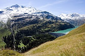
 The Güferhorn (right) from Zervreilasee | |
| Highest point | |
| Elevation | 3,379 m (11,086 ft) |
| Prominence | 400 m (1,300 ft)[1] |
| Parent peak | Rheinwaldhorn |
| Isolation | 2.67 km (1.66 mi) |
| Listing | Alpine mountains above 3000 m |
| Coordinates | 46°30′45″N 9°3′47.1″E |
| Geography | |
| Parent range | Lepontine Alps |
References
- Swisstopo maps
External links
На других языках
[de] Güferhorn
Das Güferhorn ist mit 3379 m ü. M. Höhe (in älteren Karten und Führern 3383 m ü. M.) der zweithöchste Berg in den Adula-Alpen. Es gehört zur Adula-Gruppe, deren höchste Spitze das Rheinwaldhorn ist. Diese Gruppe befindet sich zwischen dem Kanton Tessin und dem Kanton Graubünden. Das Güferhorn ist zusammen mit Zervreilahorn und Furggeltihorn auf der Etikette des Valserwassers abgebildet (siehe Bild in der Infobox).- [en] Güferhorn
[it] Güferhorn
Il Güferhorn (3.379 m s.l.m.) è una montagna delle Alpi dell'Adula nelle Alpi Lepontine.Текст в блоке "Читать" взят с сайта "Википедия" и доступен по лицензии Creative Commons Attribution-ShareAlike; в отдельных случаях могут действовать дополнительные условия.
Другой контент может иметь иную лицензию. Перед использованием материалов сайта WikiSort.org внимательно изучите правила лицензирования конкретных элементов наполнения сайта.
Другой контент может иметь иную лицензию. Перед использованием материалов сайта WikiSort.org внимательно изучите правила лицензирования конкретных элементов наполнения сайта.
2019-2025
WikiSort.org - проект по пересортировке и дополнению контента Википедии
WikiSort.org - проект по пересортировке и дополнению контента Википедии
