geo.wikisort.org - Mountains
Gora Severny or Gora Severnyy Nunatak (Russian: Гора Северный Нунатак) is a nunatak in Novaya Zemlya. It is one of the very few nunataks of the Russian Federation. Administratively it falls under the Arkhangelsk Oblast.
| Gora Severny Nunatak | |
|---|---|
 Novaya Zemlya, Russia | |
| Highest point | |
| Elevation | 727 m (2,385 ft)[1] |
| Coordinates | 76°36′N 66°20′E[2] |
| Naming | |
| Native name | Гора Северный Нунатак (Russian) |
| Geography | |
| Location | Novaya Zemlya, Russia |
| Climbing | |
| First ascent | Unknown |
 | |
Geography
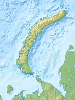
Gora Severny Nunatak is located in the northern section of Severny Island ice cap, the long ice cap covering most of inner Severny Island, Novaya Zemlya. It is not far from the western coast of the island.[2]
The nunatak is 4.9 km in length and its maximum width is 2.4 km.[2] Its highest elevation is 727 metres (2,385 ft) high.[1]
 |
See also
- List of Nunataks
References
- GoogleEarth
- "Gora Severnyy Nunatak". Mapcarta. Retrieved 24 September 2016.
This Russian location article is a stub. You can help Wikipedia by expanding it. |
Текст в блоке "Читать" взят с сайта "Википедия" и доступен по лицензии Creative Commons Attribution-ShareAlike; в отдельных случаях могут действовать дополнительные условия.
Другой контент может иметь иную лицензию. Перед использованием материалов сайта WikiSort.org внимательно изучите правила лицензирования конкретных элементов наполнения сайта.
Другой контент может иметь иную лицензию. Перед использованием материалов сайта WikiSort.org внимательно изучите правила лицензирования конкретных элементов наполнения сайта.
2019-2026
WikiSort.org - проект по пересортировке и дополнению контента Википедии
WikiSort.org - проект по пересортировке и дополнению контента Википедии