geo.wikisort.org - Mountains
Explorers Monument is a 4,572-foot-elevation (1,394 meter) summit located in the Grand Canyon, in Coconino County of northern Arizona, US.[2] It is situated 3.5 miles due west of Mount Huethawali, within a meander of the Colorado River. It towers over 2,400 feet (730 meters) directly above the river, providing rafters a view of this landmark. Explorers Monument is topped by rock of the Pennsylvanian-Permian Supai Group which overlays cliff-forming Mississippian Redwall Limestone, which in turn overlays Cambrian Tonto Group.[3] According to the Köppen climate classification system, Explorers Monument is located in a cold semi-arid climate zone.[4]
| Explorers Monument | |
|---|---|
 Southwest aspect | |
| Highest point | |
| Elevation | 4,572 ft (1,394 m)[1] |
| Prominence | 272 ft (83 m)[1] |
| Parent peak | Marcos Terrace (5,140 ft)[1] |
| Isolation | 2.06 mi (3.32 km)[1] |
| Coordinates | 36°12′17″N 112°26′42″W[2] |
| Geography | |
 Explorers Monument Location in Arizona  Explorers Monument Explorers Monument (the United States) | |
| Location | Grand Canyon National Park Coconino County, Arizona, US |
| Parent range | Colorado Plateau |
| Topo map | USGS Explorers Monument |
| Geology | |
| Type of rock | sandstone, limestone, mudstone |
| Climbing | |
| Easiest route | class 4 climbing[1] |
History
Explorers Monument was originally named "Marcos Monument" by George Wharton James because it adjoins Marcos Terrace, which is named for Marcos de Niza, a Franciscan friar and explorer.[2] Subsequently, the United States Geological Survey proposed and in 1908 officially adopted the name "Explorers Monument" to honor Grand Canyon explorers Joseph Christmas Ives, George Wheeler, Edward Beale, Almon Thompson, and John Newberry.[5] [2]
See also
- Geology of the Grand Canyon area
- History of the Grand Canyon area
Gallery

 Explorers Monument centered near bottom within meander. From airliner.
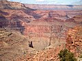


References
- "Explorers Monument – 4,572' AZ". Lists of John. Retrieved December 27, 2020.
- "Explorers Monument". Geographic Names Information System. United States Geological Survey. Retrieved 2020-12-27.
- N.H. Darton, Story of the Grand Canyon of Arizona, 1917.
- Peel, M. C.; Finlayson, B. L.; McMahon, T. A. (2007). "Updated world map of the Köppen−Geiger climate classification". Hydrol. Earth Syst. Sci. 11. ISSN 1027-5606.
- Randy Moore and Kara Felicia Witt, The Grand Canyon: An Encyclopedia of Geography, History, and Culture, 2018, ABC-CLIO Publisher, page 74.
External links
- Weather forecast: National Weather Service
- Aerial view Explorers Monument, Mancos Terrace, Colorado River: Flickr
Другой контент может иметь иную лицензию. Перед использованием материалов сайта WikiSort.org внимательно изучите правила лицензирования конкретных элементов наполнения сайта.
WikiSort.org - проект по пересортировке и дополнению контента Википедии