geo.wikisort.org - Mountains
The Executive Committee Range is a mountain range consisting of five major volcanoes, which trends north-south for 80 km (50 mi) along the 126th meridian west, in Marie Byrd Land, Antarctica.[1]
| Executive Committee Range | |
|---|---|
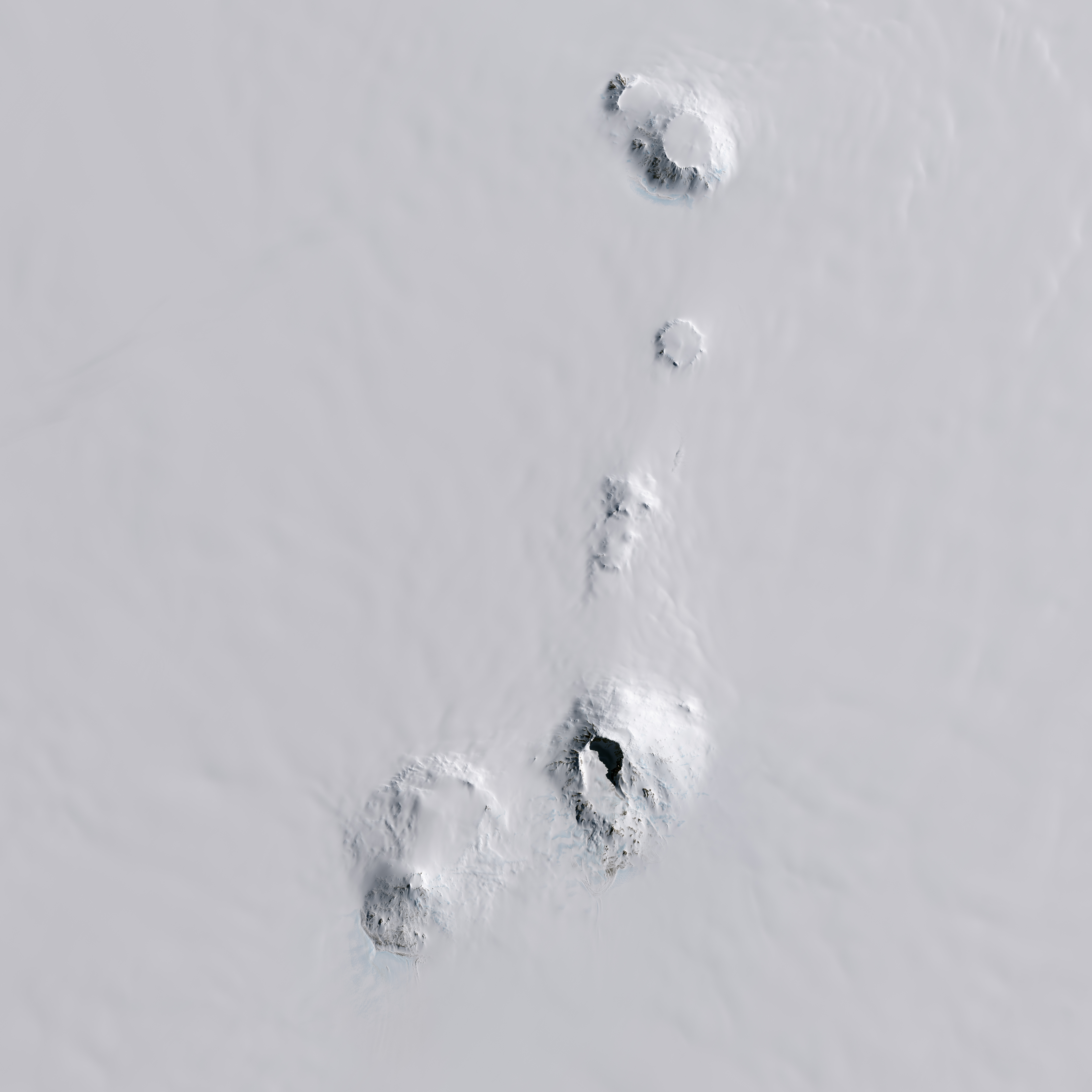 2014 Landsat 8 image of the five mountains in the Executive Committee Range | |
| Highest point | |
| Peak | Mount Sidley |
| Elevation | 4,285 m (14,058 ft) |
| Geography | |
 Location in Antarctica | |
| Continent | Antarctica |
| Region | Marie Byrd Land |
| Range coordinates | 76°50′S 126°06′W |
| Geology | |
| Volcanic field | Marie Byrd Land Volcanic Province |
The complete range was discovered by the United States Antarctic Service Expedition (1939–41), during a flyover of the area on 15 December 1940, and named for the Executive Committee of the Expedition. Four of the five mountains are named in honor of individual members of the committee; Mount Sidley, the most imposing mountain in the range and highest volcano in Antarctica, had been discovered and named by Rear Admiral Byrd in 1934, during his privately funded Second Antarctic Expedition. The entire range was mapped in detail, by the United States Geological Survey, using various surveys and U.S. Navy trimetrogon photography performed from 1958 to 1960.[1]
Mountains
The following are the five mountains, all volcanic in origin, of the Executive Committee Range, in order from south to north.
Mount Waesche
Mount Waesche, the southernmost mountain in the range, rises to 3,292 metres (10,801 ft).

Mount Sidley
Mount Sidley, northeast of Mount Waesche, is the highest in the range and the highest volcano in Antarctica, with a summit of 4,285 metres (14,058 ft).
Mount Hartigan
Mount Hartigan (76°52′S 126°00′W) is a broad mountain immediately north of Mount Sidley. Mount Hartigan rises to 2,815 metres (9,236 ft), at the higher of its twin Boudette Peaks, located in its northern portion.
The mountain was discovered by the United States Antarctic Service expedition on a flight, Dec. 15, 1940, and named for Rear Admiral Charles C. Hartigan, U.S. Navy (USN), Navy Department member of the Antarctic Service Executive Committee.[2]

Mount Cumming
Mount Cumming (76°40′S 125°48′W) is a low, mostly snow-covered mountain, volcanic in origin, located midway between Mount Hampton and Mount Hartigan. A circular snow-covered crater occupies the summit area, rising to 2,610 metres (8,560 ft) at Annexstad Peak, on the southwest side of the crater rim.
Discovered by the U.S. Antarctic Service (USAS) (1939–41) on a flight, Dec. 15, 1940, and named for Hugh S. Cumming, Jr., State Department member of the U.S. Antarctic Service (USAS) Executive Committee. Mapped by U.S. Geological Survey (USGS) from surveys and U.S. Navy trimetrogon photography, 1958-60.[3]
Mount Hampton
Mount Hampton, the northernmost mountain in the range, rises to 3,325 metres (10,909 ft) at Marks Peak, on the south side of its crater rim.
Other geological features
Peaks
The five mountains have a number of associated subsidiary peaks that have been identified and named.
Chang Peak rises to 2,920 metres (9,580 ft) on the northeastern slope of Mount Waesche.
Doumani Peak rises to 2,675 metres (8,776 ft) on the southern slopes of Mount Sidley.
Lavris Peak rises to 2,745 metres (9,006 ft) in the northeastern portion of Mount Hartigan.
Le Vaux Peak (76°40′S 125°43′W) is a small peak on the east side of the crater rim of Mount Cumming. Mapped by United States Geological Survey (USGS) from surveys and U.S. Navy aerial photographs, 1958-60. Named by Advisory Committee on Antarctic Names (US-ACAN) for Howard A. Le Vaux, auroral physicist at Byrd Station, 1959, and a member of the Marie Byrd Land Traverse Party, 1959-60.[4]
Mintz Peak rises to 2,500 metres (8,200 ft) on the southeast corner of Mount Hartigan.
Tusing Peak rises to 2,650 metres (8,690 ft) from the central portion of Mount Hartigan.
Whitney Peak is a conspicuous peak rising to 3,005 metres (9,859 ft), located 5 kilometres (3 mi) northwest of Mount Hampton, from which it is separated by a distinctive ice-covered saddle.
Woolam Peak is a small peak on the southern part of the crater rim of Mount Cumming.
Miscellaneous
The Feyerharm Knoll is an ice-covered knoll protruding to 2,595 metres (8,514 ft) in a 2,400 metres (7,900 ft) terrain on the lower northeastern slope of Mount Sidley. The Weiss Amphitheater is an amphitheater-like caldera, 4 kilometres (2.5 mi) wide and breached at the southern side, occupying the south-central part of Mount Sidley.
Recent and Ongoing Magmatism
In November 2013, Lough et al.[5] reported deep long period volcanic earthquakes centered at depths of 30-40 km approximately 55 km S of Mount Sidley that were interpreted as indications of present deep crustal magmatic activity beneath the Executive Committee Range. Ice penetrating radar results reported in this study indicated a sub-ice topographic feature, interpreted as a volcano, above the seismic swarms. The study also reported a mid-icecap (1400 m depth) ash layer about 8,000 years old that was interpreted as probably originating at nearby Mount Waesche.
References
| Wikimedia Commons has media related to Executive Committee Range. |
- "Executive Committee Range". Geographic Names Information System. United States Geological Survey. Retrieved 2005-07-03.
- "Mount Hartigan". Geographic Names Information System. United States Geological Survey. Retrieved 2010-06-02.
- "Mount Cumming". Geographic Names Information System. United States Geological Survey. Retrieved 2010-06-02.
- "Le Vaux Peak". Geographic Names Information System. United States Geological Survey. Retrieved 2008-04-07.
- Lough, A., Wiens, D., Barcheck, C., Aster, R., Nyblade, A., Huerta, A., Wilson, T., Seismic detection of an active subglacial volcanic center in Marie Byrd Land, Antarctica, Nature Geoscience, 10.1038/ngeo1992, 2013.
На других языках
[de] Executive Committee Range
Die Executive Committee Range ist ein Gebirgszug im westantarktischen Marie-Byrd-Land. Er besteht im Wesentlichen aus fünf großen Vulkanen (Mount Sidley, Mount Waesche, Mount Hampton, Mount Cumming und Mount Hartigan mit mehreren individuell benannten Berggipfeln) und der unmittelbar nordwestlich des Mount Hampton gelegenen Bergspitze Whitney Peak. Sie verteilen sich über eine Strecke von 80 km entlang des 126. Längengrads.- [en] Executive Committee Range
[fr] Chaîne du Comité Exécutif
La chaîne du Comité Exécutif, ou chaîne de l'Executive Committee, est une chaîne de montagnes composée de cinq volcans majeurs, située dans l'Antarctique occidental, dans la Terre Marie Byrd. Ils sont répartis sur une distance de 80 km le long du 126e méridien ouest.[ru] Эгзекьютив-Коммитти
Эгзе́кьютив-Комми́тти[2][3] (англ. Executive Committee Range — «хребет Исполнительного комитета») — хребет, часть горного массива на территории Земли Мэри Бэрд в Западной Антарктиде, простирающийся между 76°20' и 77°20' южной широты.Другой контент может иметь иную лицензию. Перед использованием материалов сайта WikiSort.org внимательно изучите правила лицензирования конкретных элементов наполнения сайта.
WikiSort.org - проект по пересортировке и дополнению контента Википедии