geo.wikisort.org - Mountains
The Ennstal Alps (German Ennstaler Alpen), the Alps of the Enns valley, are a mountain range of the Northern Limestone Alps System. They are located primarily in the Austrian state of Styria, and also into the state of Upper Austria.
| Ennstal Alps | |
|---|---|
| German: Ennstaler Alpen | |
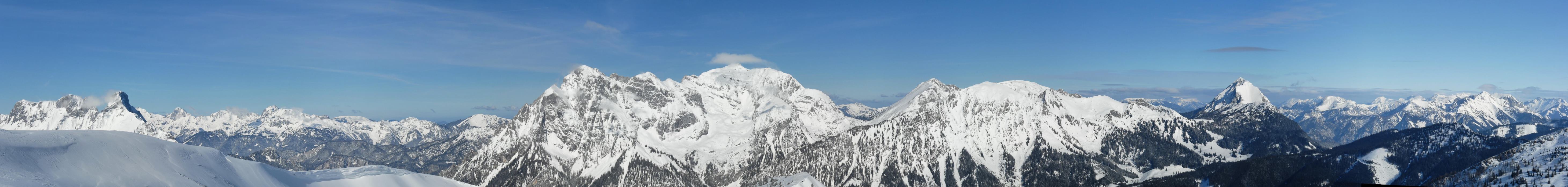
 Hochtor - Ödstein Group (Gesäuse) (from right to left) as seen from Hoher Zinken in the south | |
| Highest point | |
| Peak | Hochtor |
| Elevation | 2,369 m (7,772 ft) |
| Coordinates | 47°33′42″N 14°37′50″E |
| Geography | |
 Ennstal Alps (in red) within the Alps.
The borders of the range according to Alpine Club classification of the Eastern Alps | |
| Country | Austria |
| States | Styria and Upper Austria |
| Range coordinates | 47°37′N 14°35′E |
| Parent range | Northern Limestone Alps |
The most famous scenery in the Ennstal Alps is the Gesäuse, a valley where the Enns river cuts through the limestone.
Geography
The Ennstal Alps range is defined by:
- the lineup of Liezen, Pyhrn Pass, and Windischgarsten on the west.
- Hengst Pass and the Laussabach on the north.
- the lineup of the River Enns (from Altenmarkt bei Sankt Gallen to Hieflau), Erzbach, and Vordernbergerbach on the east
- the lineup of the Mur river (from Leoben to Sankt Michael in Obersteiermark), Liesing, and Palten on the south
Peaks + mountain groups
Mountain groups that are part of the Ennstal Alps include:
- Haller Mauern (highest summit: Großer Pyhrgas, 2,244 m)
- Gesäuse Mountains, including the Buchstein Group (2,224 m), Reichenstein Group (2.251 m) and Hochtor Group (Hochtor, 2,369 m) and the Lugauer (2,217 m).
- Eisenerzer Reichenstein 2,165 m (Eisenerz Alps), with the preceding massifs of Reiting (including the Gößeck its main summit, 2,214 m) (in the south) and the Kaiserschild (2,105 m) in the north.
Gesäuse − Enns river valley


The Ennstal Alps range is pierced in the north by the Enns river. The Enns river valley name in German is Gesäuse. The valley is accompanied by the only roads and railway lines that run through the Ennstal Alps.
Adjacent mountain ranges
Other Alps mountain ranges that border on the Ennstal Alps include:
- Upper Austrian Prealps (to the north)
- Ybbstal Alps (to the northeast)
- Hochschwab (to the east)
- Lavanttal Alps (to the southeast)
- Seckauer Tauern (to the south)
- Rottenmanner and Wölzer Tauern (to the southwest)
- Totes Gebirge (to the west)
Settlements
Settlement within the range is restricted to the Gesäuse and several mountain valleys.
- The main villages within the Gesäuse are Admont, Hieflau, and Großreifling.
- Settlements in the mountain valleys include: Radmer, Johnsbach, and St. Gallen.
Towns in valleys around the perimeter of the range include: Leoben, Liezen, and Eisenerz.
See also
- Limestone Alps
- Mountain ranges of the Alps
![]() Media related to Ennstaler Alpen at Wikimedia Commons
Media related to Ennstaler Alpen at Wikimedia Commons
References

Authority control | |
|---|---|
| General |
|
| National libraries | |
На других языках
[de] Ennstaler Alpen
Die Ennstaler Alpen sind eine Gebirgsgruppe der Nördlichen Ostalpen in der Steiermark, ein kleiner Teil im Nordwesten befindet sich auch in Oberösterreich. Die Landschaft umfasst in ihrem zentralen Teil kleinere Bergketten der Nördlichen Kalkalpen mit Hochgebirgscharakter aus triassischen Kalken, die das Gesäuse, ein Durchbruchstal der Enns, und das Admonter Becken umsäumen. Große Teile bilden dabei den Nationalpark Gesäuse. Hier findet sich mit dem Hochtor (2369 m) auch die höchste Erhebung der Gruppe. Der südliche Teil der Ennstaler Alpen wird auch als Eisenerzer Alpen bezeichnet und zählt geologisch überwiegend zur Grauwackenzone. Er zeichnet sich durch ein vielfältiges landschaftliches Erscheinungsbild, mit einem mehrfachen Wechsel von Massiven aus Kalkstein und Silikatgestein sowie von Bergketten und Plateaustöcken aus. Am Erzberg besteht der größte Eisenerz-Tagbau Mitteleuropas. Der Nordteil der Ennstaler Alpen im Raum St. Gallen weist Mittelgebirgscharakter auf und ist vergleichsweise touristisch unbedeutend.- [en] Ennstal Alps
[fr] Alpes d'Ennstal
Les Alpes d'Ennstal sont un massif des Préalpes orientales septentrionales. Il s'élève en Autriche (limite entre le Land de Styrie et la Haute-Autriche).[it] Alpi dell'Ennstal
Le Alpi dell'Ennstal (in tedesco Ennstaler Alpen) sono una sottosezione[1] delle Alpi Settentrionali di Stiria. La vetta più alta è l'Hochtor che raggiunge i 2.369 m s.l.m..Другой контент может иметь иную лицензию. Перед использованием материалов сайта WikiSort.org внимательно изучите правила лицензирования конкретных элементов наполнения сайта.
WikiSort.org - проект по пересортировке и дополнению контента Википедии