geo.wikisort.org - Mountains
Deva Temple is a 7,353-foot-elevation (2,241 meter) summit located in the Grand Canyon, in Coconino County of northern Arizona, USA.[2] It is situated three miles south of the North Rim's Bright Angel Point, and towers 3,700 feet (1,130 meters) above Bright Angel Canyon. Its nearest higher neighbor is Brahma Temple, 1.5 mile to the south. Other neighbors include Zoroaster Temple 2.5 miles to the south-southwest, Manu Temple three miles to the west-northwest, and Buddha Temple, 3.5 miles to the west. Deva Temple was named by Henry Gannett, a geographer for Clarence Dutton, in following Dutton's practice of naming features in the Grand Canyon after mythological deities, in this case, Deva.[2] [4] This geographical feature's name was officially adopted in 1906 by the U.S. Board on Geographic Names.[2] According to the Köppen climate classification system, Deva Temple is located in a Cold semi-arid climate zone.[5]
| Deva Temple | |
|---|---|
 North aspect at sunset | |
| Highest point | |
| Elevation | 7,353 ft (2,241 m)[1] |
| Prominence | 693 ft (211 m)[1] |
| Parent peak | Brahma Temple (7,551 ft)[1] |
| Isolation | 1.56 mi (2.51 km)[1] |
| Coordinates | 36°09′08″N 112°01′54″W[2] |
| Geography | |
 Deva Temple  Deva Temple | |
| Location | Grand Canyon National Park Coconino County, Arizona, US |
| Parent range | Kaibab Plateau Colorado Plateau |
| Topo map | USGS Bright Angel Point |
| Geology | |
| Type of rock | Coconino Sandstone |
| Climbing | |
| First ascent | July 17, 1959 Harvey Butchart[3] |
Geology
The summit of Deva Temple is composed of cream-colored, cliff-forming, Permian Coconino Sandstone with a small, remnant Kaibab Limestone caprock.[6] The sandstone, which is the third-youngest of the strata in the Grand Canyon, was deposited 265 million years ago as sand dunes. Below the Coconino Sandstone is slope-forming, Permian Hermit Formation, which in turn overlays the Pennsylvanian-Permian Supai Group. Further down are strata of Mississippian Redwall Limestone, Cambrian Tonto Group, and finally Proterozoic Unkar Group at creek level.[7] Precipitation runoff from Deva Temple drains south into the Colorado River via Bright Angel Creek on its west side, and Clear Creek on the east side.
Gallery
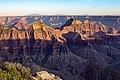 Deva Temple (left of center), Brahma and Zoroaster Temples (right) seen from the North Rim at Bright Angel Point
 Deva (left), Brahma (center), and Zoroaster Temples seen from North Rim
 Deva Temple (left), Brahma Temple (right)
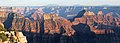 Deva Temple (left of center), Brahma and Zoroaster Temples (right) seen from the North Rim at Bright Angel Point
 Angels Gate (left) and Deva Temple (right)
 Wotans Throne, Angels Gate, and Deva Temple


See also
- Geology of the Grand Canyon area
References
- "Deva Temple – 7,353' AZ". Lists of John. Retrieved December 25, 2020.
- "Deva Temple". Geographic Names Information System. United States Geological Survey. Retrieved 2020-12-25.
- "Harvey Butchart's Grand Canyon Hiking Logs". cholla.mmto.org. Retrieved 2021-01-11.
- Randy Moore and Kara Felicia Witt, The Grand Canyon: An Encyclopedia of Geography, History, and Culture, 2018, ABC-CLIO Publisher, p. 151.
- Peel, M. C.; Finlayson, B. L.; McMahon, T. A. (2007). "Updated world map of the Köppen−Geiger climate classification". Hydrol. Earth Syst. Sci. 11. ISSN 1027-5606.
- N.H. Darton, Story of the Grand Canyon of Arizona, 1917, p. 32.
- William Kenneth Hamblin, Anatomy of the Grand Canyon: Panoramas of the Canyon's Geology, 2008, Grand Canyon Association Publisher, ISBN 9781934656013.
External links
| Wikimedia Commons has media related to Deva Temple. |
- Weather forecast: National Weather Service
Другой контент может иметь иную лицензию. Перед использованием материалов сайта WikiSort.org внимательно изучите правила лицензирования конкретных элементов наполнения сайта.
WikiSort.org - проект по пересортировке и дополнению контента Википедии