geo.wikisort.org - Mountains
The Cuchilla de Caraguatá is a range of hills in Uruguay.
Location
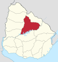
It is situated in Uruguay's largest department, Tacuarembó Department, in the north of the country.
Name
The range of hills gives its name to a village formerly known as Cuchilla de Caraguatá.
The word 'Caraguatá' originally referred to a local plant.
A nearby river is named the Caraguatá River.
Featured in literature
'Caraguatá' is featured in the poetry of a local writer, Circe Maia.[1] Maia has written a series of poems entitled 'Poemas de Caraguatá', containing reflections to which local topography, flora and fauna have given rise.
See also
References
- 'Circe Maia', Wikipedia (in Spanish) es:Circe Maia,
Capital: Tacuarembó | ||
| Municipalities |
|  |
| Towns and villages |
| |
| Sights | ||
Текст в блоке "Читать" взят с сайта "Википедия" и доступен по лицензии Creative Commons Attribution-ShareAlike; в отдельных случаях могут действовать дополнительные условия.
Другой контент может иметь иную лицензию. Перед использованием материалов сайта WikiSort.org внимательно изучите правила лицензирования конкретных элементов наполнения сайта.
Другой контент может иметь иную лицензию. Перед использованием материалов сайта WikiSort.org внимательно изучите правила лицензирования конкретных элементов наполнения сайта.
2019-2026
WikiSort.org - проект по пересортировке и дополнению контента Википедии
WikiSort.org - проект по пересортировке и дополнению контента Википедии