geo.wikisort.org - Mountains
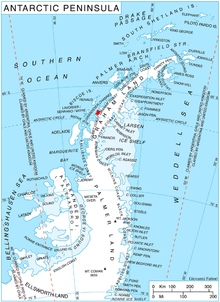
Crookes Peak (66°14′S 65°18′W) is a peak at the east side of Widmark Ice Piedmont, midway between Stair Hill and Rugg Peak on Stresher Peninsula on the west coast of Graham Land. It was charted by the British Graham Land Expedition of 1934-37 under John Rymill and was named by the UK Antarctic Place-Names Committee in 1959 for Sir William Crookes, an English chemist and physicist whose pioneer work on the optical properties of tinted glass in 1909–13 led to the design of the first satisfactory snow goggles and the prevention of snow blindness.
References
 This article incorporates public domain material from "Crookes Peak". Geographic Names Information System. United States Geological Survey.
This Graham Land location article is a stub. You can help Wikipedia by expanding it. |
На других языках
[de] Crookes Peak
Der Crookes Peak ist ein rund 1500 m hoher Berg an der Graham-Küste des Grahamlands im Norden der Antarktischen Halbinsel. Er ragt auf der Ostseite des Widmark-Piedmont-Gletschers auf halbem Weg zwischen dem Stair Hill und dem Rugg Peak auf.- [en] Crookes Peak
Текст в блоке "Читать" взят с сайта "Википедия" и доступен по лицензии Creative Commons Attribution-ShareAlike; в отдельных случаях могут действовать дополнительные условия.
Другой контент может иметь иную лицензию. Перед использованием материалов сайта WikiSort.org внимательно изучите правила лицензирования конкретных элементов наполнения сайта.
Другой контент может иметь иную лицензию. Перед использованием материалов сайта WikiSort.org внимательно изучите правила лицензирования конкретных элементов наполнения сайта.
2019-2026
WikiSort.org - проект по пересортировке и дополнению контента Википедии
WikiSort.org - проект по пересортировке и дополнению контента Википедии