geo.wikisort.org - Mountains
Creag Bheag[1] is a prominent hill in Scotland.
| Creag Bheag | |
|---|---|
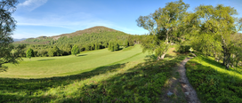 The hill as seen from Kinussie golf course | |
| Highest point | |
| Elevation | 487 m (1,598 ft)[1] |
| Prominence | 159[1] |
| Listing | Marilyn |
| Coordinates | 57.0883710°N 4.0719483°W |
| Naming | |
| English translation | small rock |
| Language of name | Scottish gaelic |
| Geography | |
| Parent range | Grampian Mountains |
| OS grid | NH 74600 01742 |
| Climbing | |
| Easiest route | Hike from Kingussie |

Etymology
The word Creag is a variation of crag (rock), while the gaelic term Bheag can be transalted as small.[2]
Features

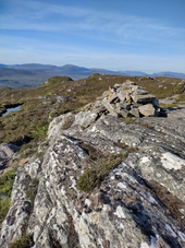
The hill overlooks from NW the centre of Kingussie; its E flanks are bordered by the Gynack Burn, a left-hand tributary of River Spey, and the N face dominates the Loch Gynack. The hilltop is marked by a cairn, as well as a nearby S summit almost at the same elevation of the main summit. Because of its topographic prominence the hill is classified as a Marilyn.[1]
History
Due to the easy access and the good panorama from its summit the Creag Behag has always been a popular walk. In 1828 some young men of Kingussie erected a memorial cairn, now disappeared, in order to mourn the loss of Alexander, the 4th Duke of Gordon. For the occasion a crowd of people reached the hilltop accompanied by a band of musicians playing their instruments.[3]
Access to the summit
The ascent to Creag Behag from Kingussie is considered a classic hillwalk, apreciated for the panoramic view from the hilltop on the surrounding area. The hike runs on well maintained and waymarked footpaths .[4]
Nature conservation
The hill, along with the surrounding area, is part of the Cairngorms National Park.
References
![]() Media related to Creag Bheag at Wikimedia Commons
Media related to Creag Bheag at Wikimedia Commons
- "Creag Bheag". DoBIH (Database of British and Irish Hills). Retrieved 11 June 2022.
- Turnbull, Ronald (2017). Walking in the Cairngorms - Over 100 Walks, Trails and Scrambles Including Lochnagar. Cicerone Press. ISBN 9781783625260. Retrieved 11 June 2022.
- "Cairns in the landscape: Migrant stones and Migrant stories in Scotland". Landscapes Beyond Land - Routes, Aesthetics, Narratives. Berghahn Books. 2012. p. 127. ISBN 9780857456717. Retrieved 11 June 2022.
- Hansen · 2022, Heather (June 2022). "57 Creag Behag". Walking Great Britain - England, Scotland, and Wales. Mountaineers Books. ISBN 9781680513189. Retrieved 11 June 2022.
Panorama
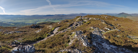 Southward panorama
 Loch Gynack and Creag Mhor from Creag Bheag


Другой контент может иметь иную лицензию. Перед использованием материалов сайта WikiSort.org внимательно изучите правила лицензирования конкретных элементов наполнения сайта.
WikiSort.org - проект по пересортировке и дополнению контента Википедии