geo.wikisort.org - Mountains
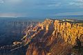
Comanche Point is a 7,073-foot-elevation (2,156 meter) summit located in the Grand Canyon, in Coconino County of northern Arizona, US.[3] Part of the Palisades of the Desert, Comanche Point is the high point on the canyon's less-visited East Rim, and is four miles north-northeast of Desert View Point, its nearest higher neighbor. Topographic relief is significant as it towers 4,400 feet (1,340 meters) above the Colorado River in 1.5 mile. Comanche Point was named in 1900 by George Wharton James for the Comanche, a Native-American nation from the Great Plains, in keeping with a practice of naming the points on the canyon's South Rim for Native American nations.[4] This geographical feature's name was officially adopted in 1906 by the U.S. Board on Geographic Names.[3] According to the Köppen climate classification system, Comanche Point is located in a Cold semi-arid climate zone.[5] On September 27, 1994, the tabloid Weekly World News ran an outlandish cover story that wreckage of a 4000-year-old UFO had been found in limestone rubble near the base of Comanche Point.[6]
| Comanche Point | |
|---|---|
 West aspect from river level | |
| Highest point | |
| Elevation | 7,073 ft (2,156 m)[1] |
| Prominence | 551 ft (168 m)[1] |
| Parent peak | Desert View Point (7,498 ft)[2] |
| Isolation | 3.91 mi (6.29 km)[2] |
| Coordinates | 36°05′33″N 111°48′12″W[3] |
| Geography | |
 Comanche Point Location in Arizona  Comanche Point Comanche Point (the United States) | |
| Location | Grand Canyon National Park Coconino County, Arizona, US |
| Parent range | Coconino Plateau[1] Colorado Plateau |
| Topo map | USGS Desert View |
| Geology | |
| Type of rock | limestone, sandstone, siltstone |
| Climbing | |
| Easiest route | class 2 |
Geology
The summit of Comanche Point is composed of Kaibab Limestone overlaying cream-colored, cliff-forming, Permian Coconino Sandstone .[7] The sandstone, which is the third-youngest of the strata in the Grand Canyon, was deposited 265 million years ago as sand dunes. Below the Coconino Sandstone is slope-forming, Permian Hermit Formation, which in turn overlays the Pennsylvanian-Permian Supai Group. Further down are strata of Mississippian Redwall Limestone, and Cambrian Tonto Group.[8] Precipitation runoff from Comanche Point drains into the nearby Colorado River.
Gallery
 From Desert View
 West aspect
 From Desert View
 West aspect at sunrise
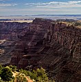 From Desert View
 Comanche Point centered, as seen from Navajo Point. Desert View Watchtower upper right.
 Comanche Point centered, as seen from Desert View during a rare total inversion
 Aerial view of north aspect


See also
- Geology of the Grand Canyon area
References
- "Comanche Point, Arizona". Peakbagger.com. Retrieved 2021-01-05.
- "Comanche Point – 7,073' AZ". Lists of John. Retrieved January 5, 2021.
- "Comanche Point". Geographic Names Information System. United States Geological Survey. Retrieved 2021-01-05.
- George Wharton James, In & Around the Grand Canyon, 1900, Little, Brown, and Company, page x (Preface).
- Peel, M. C.; Finlayson, B. L.; McMahon, T. A. (2007). "Updated world map of the Köppen−Geiger climate classification". Hydrol. Earth Syst. Sci. 11. ISSN 1027-5606.
- John Annerino, 'Hiking the Grand Canyon", 2017, Simon & Schuster, ISBN 9781510714984
- N.H. Darton, Story of the Grand Canyon of Arizona, 1917.
- William Kenneth Hamblin, Anatomy of the Grand Canyon: Panoramas of the Canyon's Geology, 2008, Grand Canyon Association Publisher, ISBN 9781934656013.
External links
| Wikimedia Commons has media related to Comanche Point. |
- Weather forecast: National Weather Service
- Comanche Point rock climbing: Mountainproject.com
- 4000-year-old UFO found near Comanche Point: Weekly World News
Другой контент может иметь иную лицензию. Перед использованием материалов сайта WikiSort.org внимательно изучите правила лицензирования конкретных элементов наполнения сайта.
WikiSort.org - проект по пересортировке и дополнению контента Википедии