geo.wikisort.org - Mountains
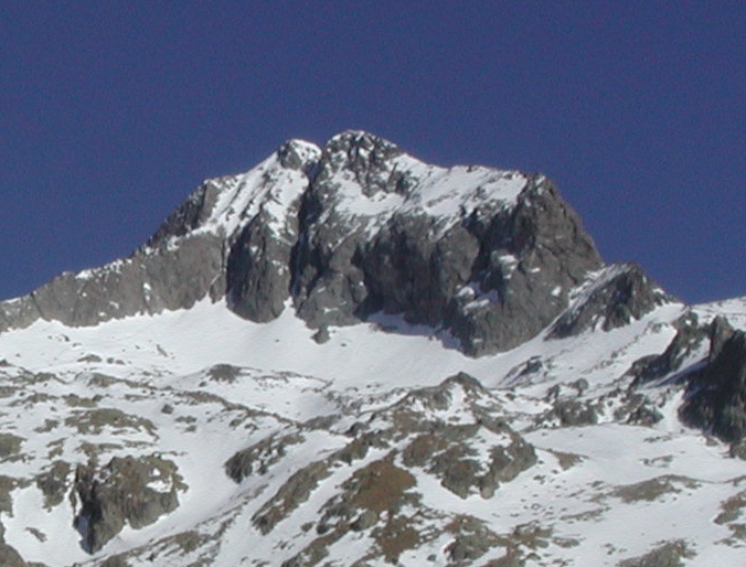
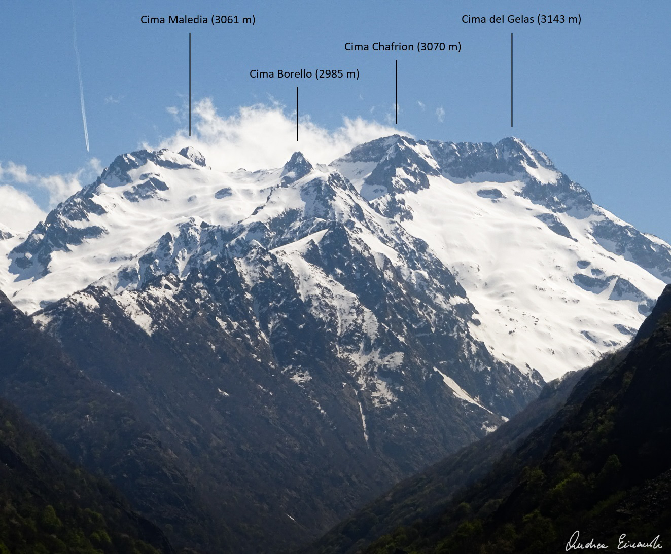
Cime du Gélas (Italian: Monte Gelàs) is a 3,143 m high mountain on the boundary between France (Provence-Alpes-Côte d'Azur region) and Italy (province of Cuneo). It is part of the Maritime Alps.
| Cime du Gélas | |
|---|---|
| Monte Gelàs | |
 | |
| Highest point | |
| Elevation | 3,143 m (10,312 ft) |
| Prominence | 669 m (2,195 ft) [1] |
| Isolation | 8.51 km (5.29 mi) |
| Listing | Alpine mountains above 3000 m |
| Coordinates | 44°07′30″N 7°23′20″E |
| Geography | |
 Cime du Gélas Piedmont, Italy Provence-Alpes-Côte d'Azur, France | |
| Parent range | Maritime Alps |
| Climbing | |
| First ascent | 1864 by Paolo di Saint-Robert |
It is the highest peak of the Mercantour National Park, while on the Italian side it is included in the Maritime Alps Natural Park. Geologically, it is part of the Mercantour-Argentera massif, and is mostly formed by granitoid gneiss. The peak is composed of two smaller ones, divided by a gorge; the highest peak is the northern one, which is topped by a cross built here by priests from Cuneo.
The mountain's name derives from the glaciers which occupy its northern slopes, which have however reduced substantially during the late 20th century.
References
- Cime du Gélas, France/Italy, www.peakbagger.com (accessed on April 2014)
Maps
- Italian official cartography (Istituto Geografico Militare - IGM); on-line version: www.pcn.minambiente.it
- French official cartography (Institut Géographique National - IGN); on-line version: www.geoportail.fr
External links
- Geologic map (in Italian)
На других языках
[de] Cime du Gélas
Die Cime du Gélas (dt. Eisspitze) ist ein Dreitausender in den Seealpen. Mit einer Höhe von 3143 m ist sie der höchste Berg des Parc National du Mercantour und einer der südlichsten Dreitausender der Alpen. Der Gipfel befindet sich auf der Grenze zwischen der italienischen Provinz Cuneo und dem französischen Département Alpes-Maritimes. Die Erstbesteigung erfolgte 1864 durch Paolo di Saint-Robert.- [en] Cime du Gélas
[fr] Cime du Gélas
La cime du Gélas est un sommet frontalier situé dans la chaîne des Alpes, dans le massif du Mercantour-Argentera, entre les Alpes-Maritimes (région Provence-Alpes-Côte d'Azur, France) et la province de Coni (Piémont, Italie). Sa géomorphologie particulière permet une ascension relativement aisée, comme en témoigne l'ouverture de la voie Normale en 1864.[it] Monte Gelàs
Il monte Gelàs, detto anche cima dei Gelas (in francese Cime du Gélas), è una montagna delle Alpi Marittime alta 3.143 m. Si trova sul confine italo-francese, tra la provincia di Cuneo ed il dipartimento delle Alpi Marittime.[ru] Жела
Жела́ (фр. Cime du Gélas) — горная вершина на границе Франции (департамент Приморские Альпы) и Италии (провинция Кунео), наивысшая точка массива Меркантур в Приморских Альпах. Высота — 3143 м..Текст в блоке "Читать" взят с сайта "Википедия" и доступен по лицензии Creative Commons Attribution-ShareAlike; в отдельных случаях могут действовать дополнительные условия.
Другой контент может иметь иную лицензию. Перед использованием материалов сайта WikiSort.org внимательно изучите правила лицензирования конкретных элементов наполнения сайта.
Другой контент может иметь иную лицензию. Перед использованием материалов сайта WikiSort.org внимательно изучите правила лицензирования конкретных элементов наполнения сайта.
2019-2026
WikiSort.org - проект по пересортировке и дополнению контента Википедии
WikiSort.org - проект по пересортировке и дополнению контента Википедии