geo.wikisort.org - Mountains
Churfürsten is a mountain range in the Canton of St. Gallen, Switzerland. They form the natural boundary between the canton's Toggenburg and Sarganserland districts. They are the southernmost range of the Appenzell Alps, separated from the Glarus Alps by the Seez river and Walensee. They consist of a limestone ridge running east to west, with the individual peaks formed by erosion. The ridge is defined much more sharply to the south than to the north, with an almost vertical drop of several hundred meters towards Walenstadtberg and eventually Lake Walensee at 419 m. The southern slope of the range was significantly formed by the Rhine Glacier during the Würm glaciation.

| Churfürsten (Electors) | |
|---|---|
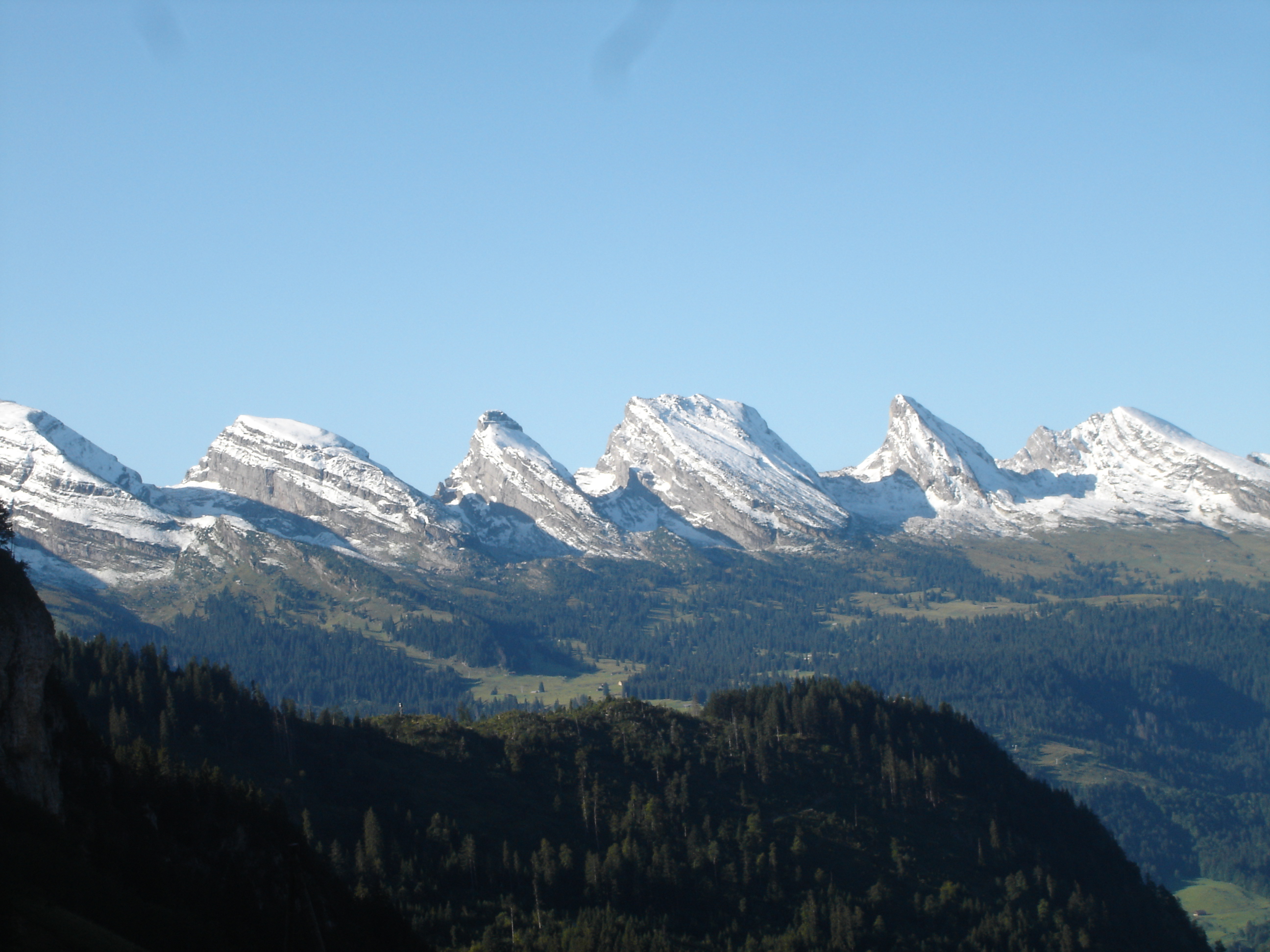 The Churfürsten range as seen from the north (in September 2006); from left to right: Hinterrugg, Schibestoll, Zuestoll, Brisi, Frümsel, Selun. | |
| Highest point | |
| Elevation | 2,306 m (7,566 ft) |
| Coordinates | 47°9′7″N 9°17′53″E |
The name is a plural, indicating the peaks forming the historical boundary of the bishopric of Chur.
It has historically also been folk-etymologized as Kurfürsten, i.e. the 7 prince-electors of the Holy Roman Empire who in the later medieval period (until 1648) numbered seven, which in turn encouraged the count of seven main or "official" peaks.[1]
The standard "seven peaks" of the Churfürsten are (from west to east):
- Selun (2205 m)
- Frümsel (2263 m)
- Brisi (2279 m)
- Zuestoll (2235 m)
- Schibenstoll (2234 m)
- Hinterrugg (2306 m)
- Chäserrugg (2262 m)
The count of exactly seven peaks is contrived; sometimes, Chäserrugg is not included and counted as part of Hinterrugg, because of its topographical prominence of a mere 14 m.
The Churfürsten seven peaks listed above have remarkably uniform heights (within just above a 100 m difference); the ridge continues both to the east and the west with a number of further peaks between 2000 and 2200 m that are not usually included as Churfürsten:
- Peaks to the west of Selun: Wart (2068 m), Schären (or Schäären, 2184 m), Nägeliberg (2153 m), Glattchamm (2084 m), Leistchamm (2101 m).
- Peaks to the east of Chäserrugg: Tristenkolben (2159 m), Gamserrugg (2076 m).
References
- Schweizerisches Idiotikon, s.v. "First" Archived 2014-02-26 at the Wayback Machine. The word First (dialectal also Fürst; from Middle High German virst) has a primary meaning of "roof-beam; gable", but secondarly came to mean "summit, mountain-top".
| Authority control |
|
|---|
На других языках
[de] Churfirsten
Die Churfirsten sind – je nach Zählweise – sechs bis dreizehn Berge im Kanton St. Gallen in der Schweiz, die zusammen eine Bergkette mit mehrfach unterbrochenem First bilden. Sie gehören zu den Appenzeller Alpen und liegen zwischen dem oberen Toggenburg und dem Walensee. In früheren Jahrhunderten lagen sie auf der Grenze zum Herrschaftsgebiet von Chur.- [en] Churfirsten
[fr] Churfirsten
Les Churfirsten sont une chaîne de montagnes dans le canton de Saint-Gall, en Suisse, qui fait partie des Préalpes appenzelloises. Elle se trouve entre le haut Toggenburg et le lac de Walenstadt.[it] Gruppo del Churfirsten
Il Gruppo del Churfirsten è un massiccio montuoso delle Prealpi di Appenzello e di San Gallo nelle Prealpi Svizzere. Si trova nel Canton San Gallo in Svizzera.[ru] Курфирстен
Курфирстен (нем. Churfirsten) — горный хребет в кантоне Санкт-Галлен в Швейцарии. Образует естественную границу между избирательными округами Тоггенбург и Зарганзерланд.Другой контент может иметь иную лицензию. Перед использованием материалов сайта WikiSort.org внимательно изучите правила лицензирования конкретных элементов наполнения сайта.
WikiSort.org - проект по пересортировке и дополнению контента Википедии