geo.wikisort.org - Mountains
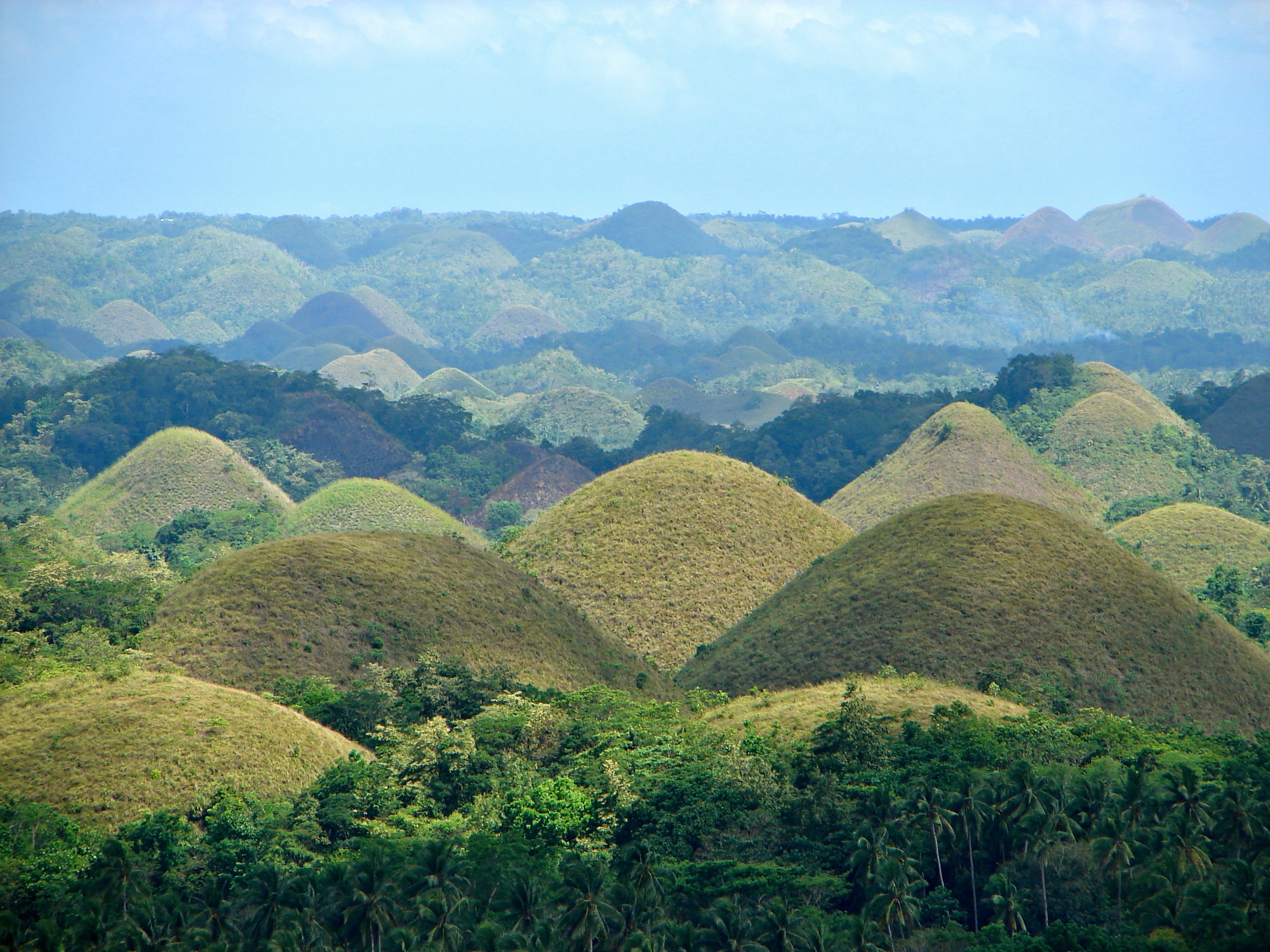
The Chocolate Hills (Cebuano: Mga Bungtod sa Tsokolate, Tagalog: Mga Tsokolateng Burol) are a geological formation in the Bohol province of the Philippines.[1] There are at least 1,260 hills, but there may be as many as 1,776 hills spread over an area of more than 50 square kilometers (20 sq mi).[2] They are covered in green grass that turns brown during the dry season, hence the name.
| Chocolate Hills | |
|---|---|
 The Chocolate Hills in Carmen, Bohol | |
| Highest point | |
| Elevation | 120 m (390 ft) |
| Coordinates | 9°55′N 124°10′E |
| Naming | |
| Native name | Mga Bungtod sa Tsokolate (Cebuano) |
| Geography | |
 Chocolate Hills  Chocolate Hills | |
| Settlement | |
| Geology | |
| Age of rock | Late Pliocene to Early Pleistocene |
| Mountain type | Conical karst hill range |
The Chocolate Hills are a famous tourist attraction of Bohol. They are featured in the provincial flag and seal to symbolize the abundance of natural attractions in the province.[3] They are in the Philippine Tourism Authority's list of tourist destinations in the Philippines;[4] they have been declared the country's third National Geological Monument and proposed for inclusion in the UNESCO World Heritage List.[4]
Description

The Chocolate Hills form a rolling terrain of haycock-shaped hills—mounds of a generally conical and almost symmetrical shape.[5] Estimated to be from 1,268 to about 1,776 individual mounds, these cone-shaped or dome-shaped hills are actually made of grass-covered limestone. The domes vary in size from 30 to 50 metres (98 to 164 ft) high with the largest being 120 metres (390 ft) in height. One of Bohol's best known tourist attractions, these unique mound-shaped hills are scattered by the hundreds throughout the towns of Carmen, Batuan and Sagbayan.[6]
Vegetation

During the dry season, the grass-covered hills dry up and turn chocolate brown.[4] The vegetation is dominated by grass species such as Imperata cylindrica and Saccharum spontaneum. Several Compositae and ferns also grow on them. In between the hills, the flat lands are cultivated with rice and other cash crops. However, the natural vegetation on the Chocolate Hills is now threatened by quarrying activities.[7]
Origin


The Chocolate Hills are conical karst hills. These hills consist of Late Pliocene to Early Pleistocene, thin to medium bedded, sandy to rubbly marine limestone. These limestones contain the abundant fossils of shallow marine foraminifera, coral, mollusks, and algae.[8][9] These conical hills are geomorphological features called cockpit karst, which were created by a combination of the dissolution of limestone by rainfall, surface water, and groundwater, and their subaerial erosion by streams after they had been uplifted above sea level and fractured by tectonic processes. These hills are separated by well developed flat plains and contain numerous caves and springs. The Chocolate Hills are considered to be a remarkable example of conical karst topography.[10][11][12]
The origin for the conical karst of the Chocolate Hills is described in popular terms on the bronze plaque at the viewing deck in Carmen, Bohol. This plaque states that they are eroded formations of a type of marine limestone that sits on top of hardened clay.[13][14] The plaque reads:
The unique land form known as the Chocolate Hills of Bohol was formed ages ago by the uplift of coral deposits and the action of rain water and erosion.[13]
The plaque also makes reference to a fanciful explanation of the origin of the Chocolate Hills that is unsupported by any published scientific research, e.g. neither Hillmer[8] nor Travaglia and others,[9] when it states:
the grassy hills were once coral reefs that erupted from the sea in a massive geologic shift. Wind and water put on the finishing touches over hundreds of thousands of years.[13]
Self-published, popular web pages present a variety of fanciful and less credible explanations about how these hills formed. They include sub-oceanic volcanism; limestone covered blocks created by the destruction of an active volcano in a cataclysmic eruption;[15] and tidal movements.[16] The lack of any exposed or associated volcanic rocks in the Chocolate Hills refutes the popular theories involving volcanic eruptions. The theories involving either a sudden, massive geologic shift, coral reefs being erupted from the sea, or tidal movements lack any corroborating evidence and support among geologists.[8][9]
Legend
The Chocolate Hills inspired many legends. One tells a story of two giants fighting by throwing stones and sand on each other. After the fight, the hills remained. Another legend speaks about a young, strong giant who fell in love with a human girl. When she died, he cried and his tears then petrified and formed the Chocolate Hills.[17]
Tourism

Two of the hills have been developed into tourist resorts.[18][19] The main viewing point of the Chocolate Hills is the government-owned Chocolate Hills Complex in Carmen, about 55 km (34 miles) from the regional capital Tagbilaran.[20] The other main point to view the Chocolate Hills is at Sagbayan Peak, in Sagbayan, 18 km (11 miles) away from the Chocolate Hills complex in neighboring Carmen.[19]
Protection
Legislation
The National Committee on Geological Sciences declared the Chocolate Hills of Bohol a National Geological Monument on June 18, 1988, in recognition of its special characteristics, scientific importance, uniqueness, and high scenic value.[4] As such, this included the Chocolate Hills among the country's protected areas. More protection was provided by Proclamation No. 1037 signed by President Fidel V. Ramos on July 1, 1997, which established the Chocolate Hills and the areas within, around, and surrounding them located in the municipalities of Carmen, Batuan and Sagbayan, Bilar, Valencia and Sierra Bullones, Province of Bohol as a natural monument to protect and maintain its natural beauty and to provide restraining mechanisms for inappropriate exploitation.[21] As such, they are covered under the National Integrated Protected Areas System with the Department of Environment and Natural Resources (DENR) as the lead implementing agency for its protection.[22]
Land-use conflict prompted President Gloria Macapagal-Arroyo to sign an amendment to Proclamation 468 dated September 26, 1994, declaring the land around or in between Chocolate Hills as no longer part of the national monument during the Bohol Sandugo Celebration on July 17, 2002. This amendment allowed the tracts of land surrounding and within the famous tourist spot to be developed by the provincial government and other entities that have control over the area. Further, the amended proclamation ensures that the areas that have to be preserved are preserved, while those that could be developed would be excluded from the national monument area and classified as alienable and disposable by the government. The president initially decided on the issue during the joint meeting of the Regional Development Council-Regional Peace and Order Council of Region VII which was conducted at the Bohol Tropics Resort.[23]
Bills have been filed aiming to strengthen protection of the hills. On July 6, 2004, the Philippine House of Representatives introduced House Bill No. 01147 entitled "an act declaring the Chocolate Hills as national patrimony and geological monuments, penalizing their plunder, destruction or defacement, and for other purposes." The house bill was authored by Congressman Eladio "Boy" Jala and co-authored by Congressman Roilo Z. Golez and Edgar M. Chatto.[22] Though this has not been passed into law.
On May 16, 2006, the DENR submitted the Chocolate Hills to the UNESCO World Heritage for inclusion in the list of Natural Monuments because of its outstanding universal value:[4][24]
The provincial government is exerting every effort to preserve and maintain the natural wonder – including the plains between, connecting and surrounding them – since they are the major attractions in Bohol's tourism industry and a heritage to be shared with the world.[25][24]
Issues
Balancing their protection, resource utilization and tourism are the challenges faced by the Chocolate Hills. Before they were designated national geological monuments, some of the hills (about 310,455 ha (1,200 sq miles)) were classified as alienable and disposable[26] or private lands such that they were titled to some locals. The declaration consequently caused some social unrest, resulting in almost simultaneous civil uprising, led by the long-established New People's Army (generally described as Maoist guerrillas) establishing a new front, known as the Chocolate Hills Command.[11] To some farmers, the proclamation is a government scheme which suppresses their right to own lands. As such, conflicts between the New People's Army group and government military forces escalated, culminating in two major engagements.[11]
Being alienable and disposable lands, the Chocolate Hills are seen as quarrying assets and source of income for small-scale miners, as well as quarry materials for the province's construction projects. The challenge is how the national and local officials can harmonize the current needs of small-scale miners, the construction sector and the tourism sector with the preservation of the Chocolate Hills.[27] Even with their protected status, mining permits continue to be granted by DENR and local government units.[24] Hence, mining and quarrying are still taking place. Because of this, the provincial government of Bohol has requested jurisdiction over the Chocolate Hills from the DENR.[11] Meanwhile, the provincial government has suggested that the legislation defining the Natural Monument should be changed, which will require that the proclamation be redrafted and ratified by both the Philippine House and Senate. This is a cumbersome and costly process, on which no progress has been made to date.[11] Future development and investment challenges within the Chocolate Hills area include: obtaining the national government's sanction for the project; persuading landowners to sell; convincing the Protected Areas Management Board, which has jurisdiction over the hills, not to use its veto power over any investment requiring physical facilities.[28]
See also
- List of protected areas of the Philippines
- Breast-shaped hill
- Kegelkarst
References
- Eye on the Philippines Archived 2006-12-08 at the Wayback Machine Global Eye Retrieved 22 December 2006.
- Chocolate Hills Archived 2015-04-09 at the Wayback Machine Seven Natural Wonders. Retrieved 10 December 2011.
- The Bohol Flag and Seal Archived 2007-04-08 at the Wayback Machine www.bohol.gov.ph Retrieved 15 November 2006.
- Chocolate Hills Natural Monument Archived 2021-02-10 at the Wayback Machine UNESCO World Heritage Centre Retrieved 14 November 2006.
- Bohol: The Jewel Paradise of the Philippine Islands Archived 2006-05-12 at the Wayback Machine www.bohol.net Retrieved 15 November 2006.
- Bohol Archived 2006-11-17 at the Wayback Machine www.dotpcvc.gov.ph Retrieved 15 November 2006.
- Bohol Island Herbarium Archived 2006-05-08 at the Wayback Machine www.pnh.com.ph. Retrieved 14 November 2006.
- Hillmer, G., 1987, Zur geologie und morphologie der straandterrassen von Cebu und Bohol Philippinen. Berliner geographische Studien. v. 25, p. 363–376.
- Travaglia, C., R. Peebles, E. Bate, and A. Ferrer, 1987, Reconnaissance groundwater appraisal of Bohol Island, Philippines, by satellite data analysis. RSC Series no. 38. Food and Agriculture Organization of the United Nations, Rome, Italy.
- Restificar, S. D. F., M. J. Day, and P. B. Urlich, 2006, Protection of Karst in the Philippines (Varstvo Krasa na Filipinih). Archived 2021-04-28 at the Wayback Machine, 788 KB PDF version. Acta Carsologica. v. 35, no. 2, p. 121-130.
- Urlich, P. B., M. J. Day, and F. Lynagh, 2001, Policy and practice in karst landscape protection: Bohol, the Philippines. Archived 2016-03-11 at the Wayback Machine The Geographical Journal. v. 167, no. 4, pp. 305-323.
- Leman, S. L., A, Reedman, and C. S. Pei, 2008, Geoheritage of East and Southeast Asia. Archived 2011-07-19 at the Wayback Machine, 5.7 MB PDF version. The CCOP-Institute for Environment and Development, Universiti Kebangsaan, Bangi Selangor, Malaysia.
- Chocolate Hills: Philippines Vacation Archived 2007-01-07 at the Wayback Machine www.philippinesvacation.org Retrieved 15 November 2006.
- Bohol Archived 2007-01-15 at the Wayback Machine www.philippines.hvu.nl. Retrieved 15 November 2006.
- Bohol Archived 2007-03-06 at the Wayback Machine www.tambuli.com. Retrieved 15 November 2006.
- "Move over Boracay: Panglao Island beckons". inq7.net. Archived from the original on 2004-12-17. Retrieved 2008-10-14.
- The Chocolate Hills Archived 2006-12-06 at the Wayback Machine www.bohol.ph. Retrieved 14 November 2006
- Bohol God's little Paradise Archived 2006-12-21 at the Wayback Machine library.thinkquest.org. Retrieved 22 December 2006
- Chito A. Fuentes. "Sagbayan Peak: A View from the Top". Philippine Daily Inquirer. Archived from the original on 2005-11-10. Retrieved 2008-10-14.
- Bohol Island Sightseeing Archived 2006-09-03 at the Wayback Machine Bohol Island Hotels Travel Guide. Retrieved 15 November 2006.
- "Proclamation No. 1037, s. 1997". Official Gazette of the Republic of the Philippines. Manila, Philippines. 1 July 1997. Archived from the original on 28 April 2021. Retrieved 4 May 2020.
 This article incorporates text from this source, which is in the public domain.
 - "History of Bill; NO. HB01147". House of Representatives of the Philippines. 23 March 2006. Archived from the original on 28 March 2006. Retrieved 4 May 2020.
- "GMA seeks development of parts of Chocolate Hills". The Official Government Portal of the Republic of the Philippines. 17 July 2002. Archived from the original on 27 September 2007. Retrieved 4 May 2020. This article incorporates text from this source, which is in the public domain.
- "The Official Website of The Bohol Chronicle". Boholchronicle.com. Archived from the original on December 7, 2008. Retrieved 2008-10-13.
- Gov issues orders to protect Choco Hills Archived 2006-06-19 at the Wayback Machine Bohol Sunday Post Retrieved 14 November 2006.
- "Bohol Philippines - Splendour Underwater And Over Hills". TravelOnline Inc. 2000. Archived from the original on March 31, 2007. Retrieved 2008-10-13.
- CV gh Context of PA 21 Archived 2007-02-26 at the Wayback Machine www.neda7.net.ph. Retrieved 17 November 2006.
- Toontown comes to Bohol's Nature Park Archived 2007-09-27 at the Wayback Machine www.newsflash.org. Retrieved 14 November 2006.
External links
Articles
- Chocolate Hills Chocolate hills travel information
- The Chocolate Hills
- "Guv issues orders to protect Choco Hills, aid brgy workers", Bohol Sunday Post, 06/11/06
- House Bill 001147
World Heritage Sites in the Philippines | ||
|---|---|---|
| Cultural |
| |
| Natural |
| |
На других языках
- [en] Chocolate Hills
[es] Colinas de Chocolate
Las Colinas de Chocolate (inglés: Chocolate Hills) son una formación geológica inusual en Bohol, Filipinas.[1] Se compone de alrededor de 1268 conos en formas de colinas de aproximadamente el mismo tamaño, repartidas en una superficie de más de 50 kilómetros cuadrados. Están cubiertos de hierba verde que se vuelve marrón durante la estación seca; de ahí el nombre.Другой контент может иметь иную лицензию. Перед использованием материалов сайта WikiSort.org внимательно изучите правила лицензирования конкретных элементов наполнения сайта.
WikiSort.org - проект по пересортировке и дополнению контента Википедии