geo.wikisort.org - Mountains
Cheops Pyramid is a 5,401-foot-elevation (1,646 meter) summit located in the Grand Canyon, in Coconino County of Arizona, US.[3] This butte is situated four miles north of Grand Canyon Village, 2.5 miles south-southwest of Buddha Temple, and 1.7 mile south-southeast of Isis Temple, which is the nearest higher neighbor. Topographic relief is significant as it rises 3,000 feet (914 meters) above the Colorado River in 1.5 mile. It was named by George Wharton James for the fanciful resemblance to the famous pyramid constructed by Egyptian Pharaoh Cheops.[4] This was in keeping with Clarence Dutton's tradition of naming geographical features in the Grand Canyon after mythological deities.[5] This butte's name was officially adopted in 1906 by the U.S. Board on Geographic Names.[3] According to the Köppen climate classification system, Cheops Pyramid is located in a Cold semi-arid climate zone.[6]
| Cheops Pyramid | |
|---|---|
 South aspect, from South Rim's Yavapai Point | |
| Highest point | |
| Elevation | 5,401 ft (1,646 m)[1] |
| Prominence | 800 ft (240 m)[1] |
| Parent peak | Isis Temple (7,006 ft)[2] |
| Isolation | 1.72 mi (2.77 km)[2] |
| Coordinates | 36°07′13″N 112°07′12″W[3] |
| Geography | |
 Cheops Pyramid Location in Arizona  Cheops Pyramid Cheops Pyramid (the United States) | |
| Location | Grand Canyon National Park Coconino County, Arizona, US |
| Parent range | Kaibab Plateau[1] Colorado Plateau |
| Topo map | USGS Phantom Ranch |
| Geology | |
| Type of rock | sandstone, limestone, shale |
| Climbing | |
| Easiest route | class 4 climbing[2] |
Geology
Cheops Pyramid is a flat-topped erosional remnant composed of Mississippian Redwall Limestone, overlaying the green shale slopes of the Cambrian Tonto Group, and below that red shale and Shinumo Quartzite of the Proterozoic Unkar Group.[7] Precipitation runoff from Cheops Pyramid drains south to the Colorado River via Phantom Creek (east), and Ninetyone Mile Creek (west).
See also
- Geology of the Grand Canyon area
- Grand Canyon Supergroup
Gallery
 Isis Temple left, Cheops Pyramid in front, Buddha Temple right of center in back.
 Isis Temple left, Cheops Pyramid right
 Cheops Pyramid (left) and Buddha Temple (right), seen from junction of the Tonto West Trail and Bright Angel Trail
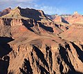
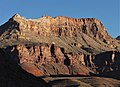 Southeast aspect from Bright Angel Trail
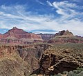 Isis Temple left, Cheops Pyramid right
 Cheops Pyramid in bullseye, from Hopi Point
 Cheops Pyramid below onlookers at Maricopa Point
 Cheops Pyramid (left) and Buddha Temple (right)


References
- "Cheops Pyramid, Arizona". Peakbagger.com. Retrieved 2021-01-16.
- "Cheops Pyramid – 5,401' AZ". Lists of John. Retrieved 2021-01-16.
- "Cheops Pyramid". Geographic Names Information System. United States Geological Survey. Retrieved 2021-01-16.
- Gregory McNamee, Grand Canyon Place Names, 1997, Mountaineers Publisher, ISBN 9780898865332, page 34.
- Randy Moore and Kara Felicia Witt, The Grand Canyon: An Encyclopedia of Geography, History, and Culture, 2018, ABC-CLIO Publisher, page 151.
- Peel, M. C.; Finlayson, B. L.; McMahon, T. A. (2007). "Updated world map of the Köppen−Geiger climate classification". Hydrol. Earth Syst. Sci. 11. ISSN 1027-5606.
- N.H. Darton, Story of the Grand Canyon of Arizona, 1917, pages 26, 37.
External links
- Weather forecast: National Weather Service
Другой контент может иметь иную лицензию. Перед использованием материалов сайта WikiSort.org внимательно изучите правила лицензирования конкретных элементов наполнения сайта.
WikiSort.org - проект по пересортировке и дополнению контента Википедии