geo.wikisort.org - Mountains
Cerro El Pital is a mountain in Central America, on the border of El Salvador and Honduras. It is located 12 km (7 mi) from the town of La Palma at a height of 2,730 m (8,957 ft) above sea level, and is the highest point in Salvadoran territory and the third from Honduras. Cerro El Pital is in the middle of a cloud forest that has an average annual temperature of 10 °C (50 °F).[2]
| Cerro El Pital | |
|---|---|
 | |
| Highest point | |
| Elevation | 2,730 m (8,960 ft)[1] |
| Prominence | 1,530 m (5,020 ft)[1] |
| Listing | Country high point Ultra |
| Coordinates | 14°23′00″N 89°07′00″W[1] |
| Naming | |
| Language of name | Spanish |
| Geography | |
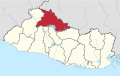
 Cerro El Pital Location of Cerro El Pital in El Salvador | |
| Location | Chalatenango, El Salvador − Honduras border[1] |
| Parent range | Sierra Madre |
It is one of the most popular tourist draws in El Salvador, with great biodiversity in a wide altitudinal range containing many endangered species of flora and fauna. The cloud forest has some of the rarest plants and animals in the country, including quetzals and other endangered species.
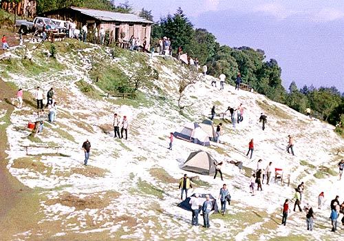
From November to February the temperature ranges between −6 °C (21 °F) and 10 °C (50 °F) (lowest recorded, in January 1956) and in the rest of the year the temperature ranges between 5 °C (41 °F) and 17 °C (63 °F). It is the coldest place in El Salvador. On 13 April 2004, much of the mountain was blanketed by an accumulation of hail during a storm, an unusual event that caused a commotion among the local community.[3]
References
- "Cerro El Pital, El Salvador". Peakbagger.com. Retrieved 17 February 2009.
- "Cerro El Pital" (in Spanish). Ministerio de Turismo de la República de El Salvador. 2005. Archived from the original on 2 May 2006. Retrieved 17 February 2009.
- Villarroel, Nathalie (13 April 2004). "El cerro El Pital fue cubierto por escarcha". El Diario de Hoy (in Spanish). Archived from the original on 26 February 2009. Retrieved 17 February 2009.
Capital: Chalatenango | ||
| Municipalities |
|  |
| Geography | ||
| Landmarks |
| |
На других языках
[de] El Pital
Der El Pital (oft auch Cerro El Pital) ist mit 2730 m der höchste Punkt von El Salvador. Er befindet sich an der Grenze zu Honduras und ist der einzige Ort in El Salvador, an dem ganzjährig Schnee fallen kann.- [en] Cerro El Pital
[es] Cerro El Pital
El cerro El Pital es una montaña transnacional, ubicada exactamente en la frontera entre El Salvador y Honduras. El Pital es la cima más alta y elevada de El Salvador y la tercera cima más alta de Honduras. Tiene una elevación de 2,730 metros sobre el nivel del mar. Además de clima fresco, El Pital tiene un bosque húmedo conformado por árboles como pino, roble, encino y ciprés.[fr] Cerro El Pital
Le Cerro El Pital est une montagne située à proximité de la frontière entre le Honduras et le Salvador et le point culminant de ce dernier pays. Sommet ultra-proéminent, il s'élève à 2 730 mètres d'altitude dans la Sierra Madre de Chiapas et est couvert d'une forêt de nuage. En 2004, il a été l'objet d'un phénomène rare dans la région en se recouvrant entièrement de grêle.[it] Cerro El Pital
Il Cerro El Pital è una montagna dell'America Centrale, situata al confine di El Salvador. La montagna è localizzata a circa 12 km dalla città di La Palma e rappresenta il punto più elevato nel territorio di El Salvador. La sua altitudine è di 2730 metri s.l.m..[ru] Серро-Эль-Питаль
Серро-Эль-Питаль (исп. Cerro El Pital) — гора на границе Сальвадора (департамент Чалатенанго, муниципалитет Сан-Игнасио[es]) и Гондураса (департамент Окотепеке, муниципалитет Окотепеке[es]). Имея высоту 2730 метров над уровнем моря, является высшей точкой Сальвадора[2] и третьей по высоте горой Гондураса.Другой контент может иметь иную лицензию. Перед использованием материалов сайта WikiSort.org внимательно изучите правила лицензирования конкретных элементов наполнения сайта.
WikiSort.org - проект по пересортировке и дополнению контента Википедии