geo.wikisort.org - Mountains
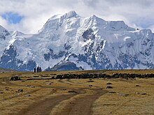
Callangate or Ccallangate is a mountain massif in the Vilcanota mountain range of the Andes in Peru.[3][4] Its highest point is Collpa Ananta[5][6][7] (possibly from Aymara and Quechua qullpa, "saltpeter"),[8][9] also known as Chimboya, with an elevation of 6,110 metres (20,046 ft).[4][5] Another peak in the massif is called Ccallangate.[5] It lies in the Cusco Region, Quispicanchi Province, Ocongate District.[7][6] Collpa Ananta is the second-highest peak in Cusco, and ranks as the 24th highest in Peru.[10][11]
| Callangate | |
|---|---|
 | |
| Highest point | |
| Elevation | 6,110 m (20,050 ft) |
| Prominence | 1,403 m (4,603 ft)[1] |
| Parent peak | Ausangate |
| Coordinates | 13°43′53″S 71°09′36″W |
| Geography | |
 Callangate Peru | |
| Location | Cusco Region, Peru |
| Parent range | Andes, Vilcanota |
| Climbing | |
| First ascent | 30 July 1957, Günther Hauser, Bernhard Kuhn (Germany)[2] |
First ascent
Callangate was first climbed by Germans Günther Hauser and Bernhard Kuhn on 30 July 1957.[2]
Elevation
Other data from available digital elevation models: SRTM 6104 metres.[12] The height of the nearest key col is 4707 meters, leading to a topographic prominence of 1403 meters.[13] Callangate is considered a Mountain Subrange according to the Dominance System [14] and its dominance is 22.96%. Its parent peak is Ausangate and the Topographic isolation is 9.7 kilometers.[13]
References
- "Callangate / Collpa Ananta / Cayangate". Andes Specialists. Retrieved 2020-04-12.
- "AAJ (American Alpine Journal)". AAJ (American Alpine Journal): 109–110. 1958.
- John Biggar. "Callangate". Andes Website. Andes.org.uk. Retrieved September 7, 2016.
- "Callangate - Peakbagger.com". peakbagger.com. Retrieved 2016-09-08.
- Peru 1:100 000, Ocongate (28-t). IGN (Instituto Geográfico Nacional - Perú).
- lib.utexas.edu Map of the area showing "Collpa Ananta"
- escale.minedu.gob.pe - UGEL maps of the Quispicanchi Province 1 (Cusco Region)
- Radio San Gabriel, "Instituto Radiofonico de Promoción Aymara" (IRPA) 1993, Republicado por Instituto de las Lenguas y Literaturas Andinas-Amazónicas (ILLLA-A) 2011, Transcripción del Vocabulario de la Lengua Aymara, P. Ludovico Bertonio 1612 (Spanish-Aymara-Aymara-Spanish dictionary)
- Teofilo Laime Ajacopa (2007). Diccionario Bilingüe Iskay simipi yuyayk’anch [Quechua-English dictionary] (PDF). La Paz, Bolivia.
- "Callangate - Cusco, Peru • peakery". Peakery.com. Archived from the original on 2013-10-14. Retrieved 2013-01-14.
- PERU, Autor: GEO GPS. "Base de datos Perú - Shapefile - *.shp - MINAM - IGN - Límites Políticos". Retrieved 2020-04-30.
- NASA, Jet Propulsion Laboratory. "Shuttle Radar Topographic Mission - Filled Data V2". Retrieved 12 April 2020.
- "Callangate / Collpa Ananta / Cayangate". Andes Specialists. Retrieved 2020-04-12.
- "Dominance - Page 2". www.8000ers.com. Retrieved 2020-04-12.
External links
See also
- Condoriquiña
- Comercocha
- List of mountains in Peru
- List of mountains in the Andes
На других языках
- [en] Callangate
[es] Callangate
Callangate, también conocido con el nombre de Collpa Ananta, es una montaña situada en el sureste del Perú en la provincia de Quispicanchi, perteneciente al departamento del Cuzco. Constituye una de las principales elevaciones de la cordillera de Vilcanota, una prolongación de la cordillera Oriental, ramal montañoso de los Andes. Su cima, cubierta por las nieves perpetuas y por extensos glaciares, alcanza los 6.110 m de altitud.[1] Sus deshielos dan lugar a pequeños cursos de agua, que alimentan la cuenca del río Urubamba.Другой контент может иметь иную лицензию. Перед использованием материалов сайта WikiSort.org внимательно изучите правила лицензирования конкретных элементов наполнения сайта.
WikiSort.org - проект по пересортировке и дополнению контента Википедии