geo.wikisort.org - Mountains
The Bridger Range, also known as the Bridger Mountains, is a subrange of the Rocky Mountains in southwestern Montana in the United States. The range runs mostly in a north–south direction between Bozeman and Maudlow. It is separated from the Gallatin Range to the south by Bozeman Pass; from the Horseshoe Hills to the west by Dry Creek; from the Crazy Mountains to the east by the Shields River valley; and from the Big Belt Mountains to the north by Sixteen Mile Creek. The highest point in the Bridger Range is Sacagawea Peak (9,596 feet (2,925 m)), which is visible to the northeast from Bozeman.
| Bridger Range | |
|---|---|
 West face of the Bridger Range | |
| Highest point | |
| Peak | Sacagawea Peak[1] |
| Elevation | 9,596 ft (2,925 m) |
| Geography | |
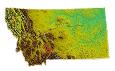 Location within the state of Montana
| |
| Country | United States |
| State | Montana |
| Range coordinates | 45°53.3′N 110°57.5′W |
| Parent range | Rocky Mountains |
Although the range is mostly in Gallatin County, a small portion extends into Park County. Bozeman Pass, at an elevation of 5,712 feet (1,741 m), is a narrow pass that lies between Bozeman and Livingston. The entire range is within Gallatin National Forest.
History
The range is named after Jim Bridger, a mountain man of the 19th century who pioneered the Bridger Trail through mountains in southern Wyoming into the Bighorn Basin in 1864.
On January 10, 1938, Northwest Airlines Flight 2 crashed in the Bridger Mountains, killing all 10 aboard. This was the first fatal crash of a Northwest Airlines aircraft.
Prominent peaks
The most prominent peaks in the Bridgers include:
- Sacagawea Peak, 45°53′44″N 110°58′08″W, 9,596 feet (2,925 m)[2]
- Hardscrabble Peak, 45°54′52″N 110°58′57″W, 9,527 feet (2,904 m)[3]
- Naya Nuki Peak, 45°53′30″N 110°57′43″W, 9,449 feet (2,880 m)[4]
- Saddle Peak, 45°47′37″N 110°56′12″W, 9,134 feet (2,784 m)[5]
- Ross Peak, 45°51′31″N 110°57′22″W, 9,012 feet (2,747 m)[6]
- Mount Baldy, 45°44′00″N 110°57′33″W, 7,106 feet (2,166 m)[7]
- Bridger Peak, 45°46′46″N 110°56′20″W, 8,583 feet (2,616 m)[8]


Recreation
Skiing
The Bridger Range is also home to the ski area Bridger Bowl. With the first rope tow installed in 1951, Bridger Bowl quickly became a popular mountain with the locals. The area has a top elevation of 8700 feet and a base elevation of 6100 feet. On average the ski area receives 350 inches (890 cm) of snow every year. Backcountry skiing is also very popular in the Bridgers, with snow being available on peaks such as Sacagawea from early November until late May/early June. Beginning in the 2008–2009 ski season, Bridger Bowl started to allow backcountry travel from the ski area via access gates on the northern and southern boundaries.
Hiking
Though many hiking trails exist, Sacagawea Peak is a favorite hiking area in the Bridgers. The hike is a short but strenuous 2.2-mile (3.5 km) one-way trek through pine forest, alpine tundra and scree fields to the top of Sacagawea Peak. The Bridger Ridge Run is a 20-mile (32 km) race which takes place in mid-August. The race follows the ridgeline from Fairy Lake to the southern end of the range.
- Images of the Bridger Range
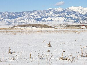 Bridger Range as seen from Bozeman, January 2009
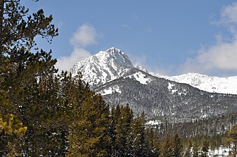 Ross Peak, Bridger Range, April 2010
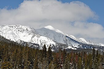 Sacagawea Peak (right) and Naya Nuki Peak (left), April 2010
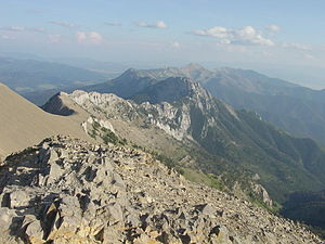 View of the Bridger Range looking south from the summit of Sacagawea Peak


See also
Notes
- "Bridger Range". Geographic Names Information System. United States Geological Survey, United States Department of the Interior.
- "Sacagawea Peak". Geographic Names Information System. United States Geological Survey, United States Department of the Interior.
- "Hardscrabble Peak". Geographic Names Information System. United States Geological Survey, United States Department of the Interior.
- "Naya Nuki Peak". Geographic Names Information System. United States Geological Survey, United States Department of the Interior.
- "Saddle Peak". Geographic Names Information System. United States Geological Survey, United States Department of the Interior.
- "Ross Peak". Geographic Names Information System. United States Geological Survey, United States Department of the Interior.
- "Mount Baldy". Geographic Names Information System. United States Geological Survey, United States Department of the Interior.
- "Bridger Peak". Geographic Names Information System. United States Geological Survey, United States Department of the Interior.
External links
State of Montana | |
|---|---|
Helena (capital) | |
| Topics | |
| Society |
|
| Regions |
|
| Largest cities | |
| Counties |
|
| Authority control: National libraries |
|---|
На других языках
- [en] Bridger Range
[fr] Chaînon Bridger (Montana)
Le chaînon Bridger est un massif montagneux des Rocheuses situé dans le Montana, aux États-Unis, et culminant à 2 946 mètres d'altitude au pic Sacagawea. Il est nommé en hommage au mountain man Jim Bridger.Другой контент может иметь иную лицензию. Перед использованием материалов сайта WikiSort.org внимательно изучите правила лицензирования конкретных элементов наполнения сайта.
WikiSort.org - проект по пересортировке и дополнению контента Википедии