geo.wikisort.org - Mountains
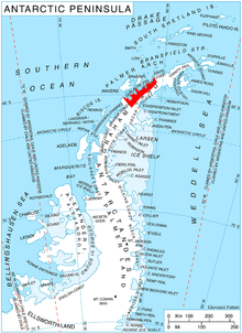
Boulton Peak (64°6′S 60°42′W) is a peak at the southeast side of Curtiss Bay, about 5 nautical miles (9 km) south of Cape Andreas in Graham Land, Antarctica. It surmounts Pirin Glacier to the north and Gregory Glacier to the south.
It was mapped from air photos taken by Hunting Aerosurveys Ltd (1955–57), and named by the UK Antarctic Place-Names Committee for Matthew Piers Watt Boulton, the English inventor of ailerons for lateral control of aircraft, in 1868.[1]
External links
- Boulton Peak Copernix satellite image
References
Citations
- "Boulton Peak". Geographic Names Information System. United States Geological Survey. Retrieved 2011-08-05.
Bibliography
![]() This article incorporates public domain material from the United States Geological Survey document: "Boulton Peak". (content from the Geographic Names Information System)
This article incorporates public domain material from the United States Geological Survey document: "Boulton Peak". (content from the Geographic Names Information System)
This Danco Coast location article is a stub. You can help Wikipedia by expanding it. |
На других языках
[de] Boulton Peak
Der Boulton Peak ist ein 1250 m hoher Berg an der Davis-Küste des Grahamlands auf der Antarktischen Halbinsel. Er ragt 8 km südlich des Kap Andreas an der Südostseite der Curtiss Bay auf.- [en] Boulton Peak
Текст в блоке "Читать" взят с сайта "Википедия" и доступен по лицензии Creative Commons Attribution-ShareAlike; в отдельных случаях могут действовать дополнительные условия.
Другой контент может иметь иную лицензию. Перед использованием материалов сайта WikiSort.org внимательно изучите правила лицензирования конкретных элементов наполнения сайта.
Другой контент может иметь иную лицензию. Перед использованием материалов сайта WikiSort.org внимательно изучите правила лицензирования конкретных элементов наполнения сайта.
2019-2026
WikiSort.org - проект по пересортировке и дополнению контента Википедии
WikiSort.org - проект по пересортировке и дополнению контента Википедии