geo.wikisort.org - Mountains
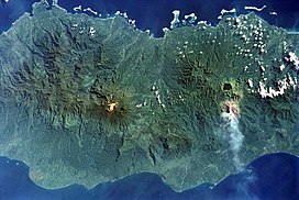
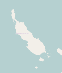
Billy Mitchell is a pyroclastic shield in the central part of the island of Bougainville, just north-east of the Bagana Volcano in Papua New Guinea. It is a small pyroclastic shield truncated by a 2 km wide caldera filled by a crater lake.[2] It is named after Billy Mitchell, a 20th-century United States Army general who is regarded as the father of the United States Air Force.
| Billy Mitchell volcano | |
|---|---|
 The dark-colored caldera lake of Billy Mitchell is at right, above an ash plume originating from Bagana. | |
| Highest point | |
| Elevation | 1,544 m (5,066 ft) |
| Isolation | 5 km (3.1 mi) |
| Coordinates | 6°06′S 155°13′E |
| Geography | |
 Billy Mitchell volcano Bougainville, Papua New Guinea | |
| Parent range | Emperor Range |
| Geology | |
| Mountain type | Pyroclastic shield |
| Volcanic arc/belt | Bougainville & Solomon Is. |
| Last eruption | 1580 ± 20 years |
| Billy Mitchell | |
|---|---|
 Billy Mitchell | |
| Location | Bougainville Island |
| Coordinates | 6.1°S 155.21667°E |
| Type | crater lake |
| Basin countries | Papua New Guinea |
| Surface area | ~3 square kilometres (1.2 sq mi)[1] |
| Max. depth | ~90 metres (300 ft)[1] |
The last two major eruptions were in 1580 AD ± 20 years and about 1030 AD. They were among the largest Holocene eruptions in Papua New Guinea. Both were explosive eruptions with a Volcanic Explosivity Index of at least 5. The 1580 AD ± 20 years eruption produced pyroclastic flows and probably formed its caldera.[3] The ignimbrite deposit from that eruption, which had a VEI of 6, extends 22 kilometres (14 mi) from the caldera to the coast, and its volume is around 10 cubic kilometres (2.4 cu mi).[1]
Caldera lake
Billy Mitchell caldera lake is about 1,013 m above sea level, has total surface area 3 km2 (1.2 sq mi), and the maximum depth approximately 88.3 m. The only fish species in the lake is the eel Anguilla megastoma. [4] Billy Mitchell lake drains into the Tekan River.[5]
See also
- List of volcanoes in Papua New Guinea
- Mount Billy Mitchell (Chugach Mountains)
- Timeline of volcanism on Earth
References
- The Billy Mitchell volcano at VolcanoLive.com
- "Billy Mitchell". Global Volcanism Program. Smithsonian Institution.
- The Billy Mitchell erupts at the Global Volcanism Program website
- Robert Schabetsberger, Ursula Sichrowsky, Alexander Scheck, Michael Schagerl, Barbara Mähnert, Bettina Sonntag, Karin Pall First Limnological Characterization of Crater Lake Billy Mitchell (Bougainville Island, Papua New Guinea) Pacific Science, 71(1):29-44 (2017). https://doi.org/10.2984/71.1.3
- Billy Mitchell volcano VolcanoDiscovery
External links
- Photo of the Billy Mitchell Crater Lake
- "Billy Mitchell". Global Volcanism Program. Smithsonian Institution. Retrieved 2011-11-08.
На других языках
[de] Billy Mitchell (Vulkan)
Billy Mitchell ist ein Pyroklastischer Schildvulkan im Zentrum der Insel Bougainville, unmittelbar nordöstlich des 1730 m hohen Bagana, eines der aktivsten Vulkane von Papua-Neuguinea. Auf dem 1544 m hohen Gipfel des Billy Mitchell befindet sich eine mit einem Kratersee gefüllte Caldera. Der Billy-Mitchell-See[1] erstreckt sich über eine Fläche von 3 km² und hat eine Tiefe von 90 m. Ein Abfluss am nördlichen Rand der Caldera führt zum Tekan-Fluss. Die beiden letzten großen Eruptionen des Vulkans ereigneten sich um das Jahr 1030 und um 1580. Dieser Ausbruch wird neben anderen vulkanischen Ereignissen und einer geringeren Aktivität der Sonne als Ursache für die Kleine Eiszeit, einer Periode relativ kühlen Klimas von Anfang des 15. Jahrhunderts bis in das 19. Jahrhundert, angesehen.- [en] Billy Mitchell (volcano)
[ru] Билли-Митчелл
Билли-Митчелл[источник не указан 745 дней] , Билли Митчелл[2] (англ. Billy Mitchell) — вулкан, расположен на острове Бугенвиль, входящий в состав одноимённой провинции, в Папуа — Новая Гвинея.Другой контент может иметь иную лицензию. Перед использованием материалов сайта WikiSort.org внимательно изучите правила лицензирования конкретных элементов наполнения сайта.
WikiSort.org - проект по пересортировке и дополнению контента Википедии