geo.wikisort.org - Bergen
Der Oligyrtos (griechisch Ολίγυρτος) ist ein Gebirge im Nordosten des Peloponnes in Griechenland. Esr erstreckt sich rund 35 Kilometer von Nordost nach Südwesten und ist ungefähr 25 Kilometer breit. Teile werden auch als Lyrkio bezeichnet. Der höchste Gipfel ist der Skipiza mit 1935 m. Weitere Erhebungen sind: Gkrimini (1831 m), Parnias (1800 m), Skiathis (1777 m) und Mavrovouni (1695 m). Diese Gebirge bildet die Grenzen zwischen den Regionen Arkadien, Korinthia und Argolis.
| Oligyrtos | ||
|---|---|---|
| Höchster Gipfel | Skipiza (1935 m) | |
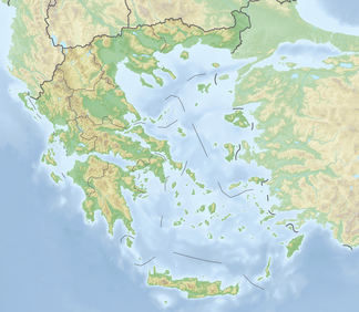
| Lage | Arkadien, Korinthia und Argolis, Griechenland | |
| Teil des | Peloponnes | |
| ||
| Koordinaten | 37° 48′ N, 22° 23′ O | |
Entstehung
Durch die Subduktion der Afrikanischen Platte unter die Ägäische Platte wurden die Gebirge des Peloponnes aufgefaltet. Das Oligyrtos-Massiv bildet dabei zusammen mit dem Kyllini (Ziria) und Aroania im Norden den nördlichsten von drei Gebirgsriegeln, die den Peloponnes gliedern. Die nördliche Grenze des Oligyrtos ist die Hochebene Stymfalia, in die das Gebirge nach Norden auch entwässert. Diese Nordhänge sind mit Griechischen Tannen bewaldet. Im Südwesten liegt das Mainalo-Gebirge (Μαίναλο), während sich im Süden das Trachy-Gebirge anschließt und das Chelmos (Aroania)-Gebirge im Nordwesten.
Vegetation
Die Vegetation besteht größtenteils aus Grasland und Phrygana, in höheren Lagen finden sich auch Steppen oder Kiefern. Nach Süden hin entwässern die Bäche in die Ebene von Kandila.
Besiedlung
Aufgrund seiner zerklüfteten Geographie gibt es im Umkreis nur kleine Dörfer. Die wichtigsten sind: Stymfalia im Norden, Skoteini und Kandila im Süden, sowie Levidi und Feneos im Westen. Am Berg liegt das Kloster Agios Nikolaos. Die Nationalstraße 7 (E 65) durchquert das Massiv durch den Tunnel von Artemisi bei Neochori (Ausfahrt 7).
Literatur
- Ernst Curtius: Peloponnesos: Eine historisch-geographische Beschreibung der Halbinsel, Band 2 (Google eBook) Perthes, 1852. 639 Seiten
Weblinks
На других языках
- [de] Oligyrtos
[en] Oligyrtos
Oligyrtos (Greek: Ολίγυρτος) is a mountain located at the junction of Arcadia, Corinthia and Argolis in the northeastern Peloponnese in Greece. The mountain diagonally stretches from southwest to northeast, with about 35 km length and 15 to 20 km breadth. Its highest point is the peak Skipiza, at1,935 m elevation.[1] Other peaks are Gkrimini (1,831 m), Parnias (1,800 m), Skiathis (1,777 m) and Mavrovouni (1,695 m). Neighboring mountain ranges are Kyllini (Ziria) to the north, Mainalo to the southwest, Trachy to the south and Chelmos (Aroania) to the northwest. Local flora consists mostly of grasslands and bushes. Pine trees and barren lands are found in higher areas. It is drained towards the Lake Stymphalia to the north, and towards the plain of Kandila to the south. In antiquity, the fortress Oligyrtus was located in a pass on the mountain.[it] Oligirto
Il monte Oligirto (in greco antico: Ολίγυρτος) è una montagna ubicata ai confini tra Arcadia, Corinzia e Argolide nel nord-est del Peloponneso in Grecia. La montagna si estende in diagonale da sud-ovest a nord-est, con circa il 35 km di lunghezza e da 15 a 20 di ampiezza. Il suo punto più alto è il picco Skipiza, a 1 935 m. s.l.m..[1] Altri picchi sono il Gkrimini (1 831 m), Parnias (1 800 m), Skiathis (1 777 m) e Mavrovouni (1 695 m). Nei dintorni si trovano il monte Cillene a nord, il Mainalo a sud-ovest, Trachy a sud e il monte Aroania a nord-ovest. La flora locale è costituita principalmente da prati e cespugli. Gli alberi di pino e le terre aride si trovano alle zone più elevate. Esso viene drenato verso il lago Stinfalia a nord, e verso la piana di Kandila a sud.Другой контент может иметь иную лицензию. Перед использованием материалов сайта WikiSort.org внимательно изучите правила лицензирования конкретных элементов наполнения сайта.
WikiSort.org - проект по пересортировке и дополнению контента Википедии