geo.wikisort.org - Bergen
Der Mount St. Augustine ist ein 1.252 Meter hoher, aktiver Vulkan in den Chigmit Mountains der Aleutenkette auf Augustine Island, einer unbewohnten Vulkaninsel vor der Südküste Alaskas in der Einfahrt des Cook Inlet 284 km südwestlich von Anchorage.
| Mount St. Augustine | ||
|---|---|---|

Mount St. Augustine (24. Januar 2006) | ||
| Höhe | 1260 m | |
| Lage | Augustine Island, Alaska, Vereinigte Staaten | |
| Koordinaten | 59° 21′ 47″ N, 153° 25′ 50″ W | |
| ||
| Typ | Lavadom | |
| Letzte Eruption | 2006 | |

Beschreibung
Der Mount St. Augustine besteht aus mehreren überlappenden Lavadomen und ist der aktivste Vulkan der Aleuten.
Die Flanken sind bedeckt von Asche und Ablagerungen der vielen pyroklastischen Ströme. Die ältesten datierten Ablagerungen sind 40.000 Jahre alt. Mindestens elf große Gesteinsabbrüche haben in den vergangenen 1800 bis 2000 Jahren die Küste erreicht.
Eruptionen
Historische Eruptionen waren meist explosiv und führten zu pyroklastischen Strömen. Große Ausbrüche sind aus folgenden Jahren bekannt:
- etwa 1650, 1812, Oktober 1883, 13. März bis 18. August 1935,
- 11. Oktober 1963 bis 19. August 1964,
- 7. bis 18. Oktober 1971,
- Januar 1976 bis Mai 1977 (Ausstoß von 65 Mio. m³ Lava sowie 150 Mio. m³ Tephra),
- 27. März bis 31. August 1986 (Ausstoß von 100 Mio. m³ Tephra),
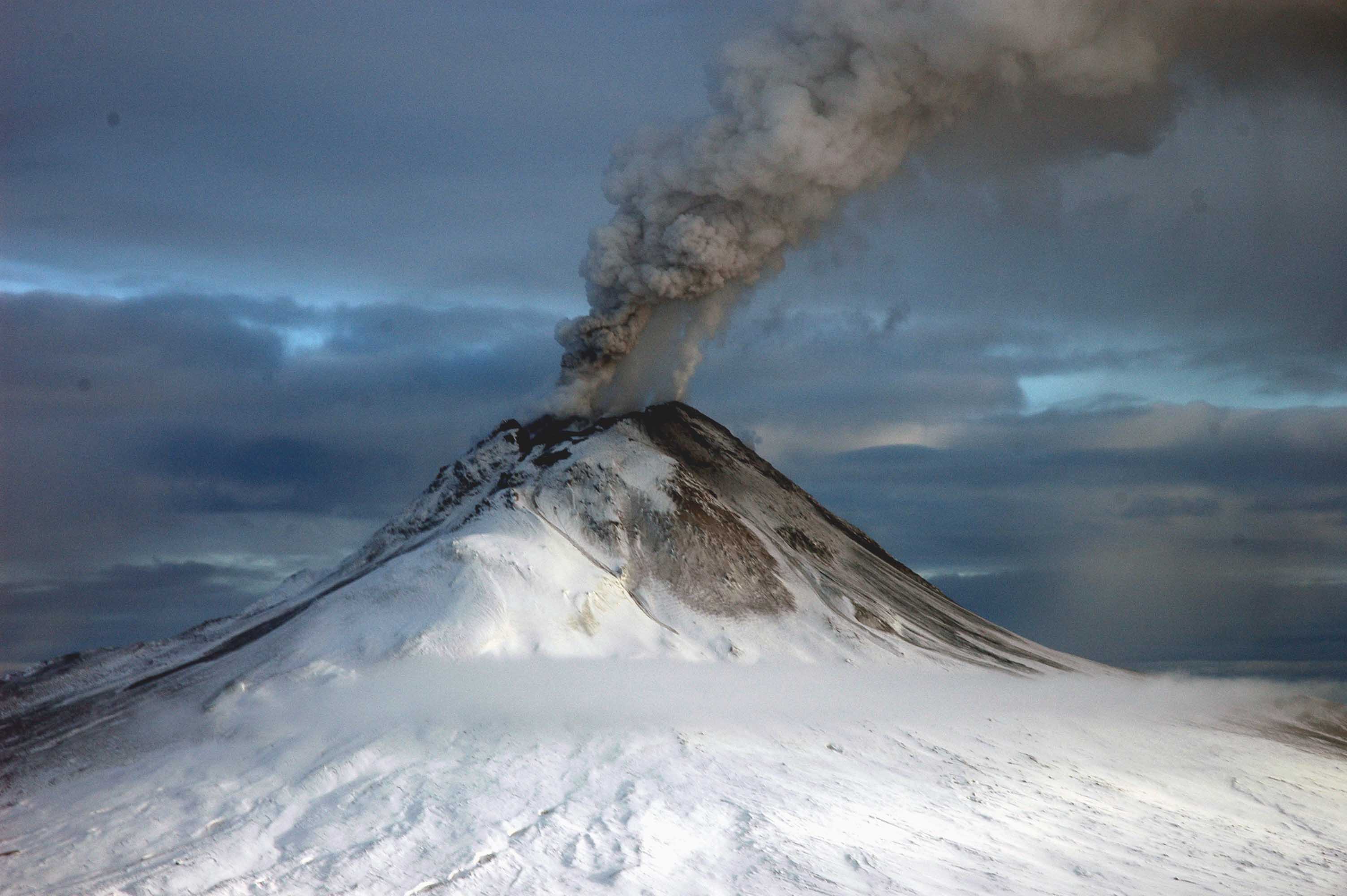
- 11. Januar bis April 2006 (explosive Eruptionen mit schwachen Beben, pyroklastischen Strömen, phreatischen Explosionen, Lavaströmen und Lahars. – 30 Mio. m³ pro Eruption, bis 15 km Höhe).[1]
 Mount St. Augustine (1986)
 Mount St. Augustine (12. Januar 2006)
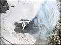 Satellitenbild des Mount St. Augustine


Weblinks
- Mount St. Augustine im Global Volcanism Program der Smithsonian Institution (englisch)
- Alaska Vulkan Observatorium (englisch)
- Webcam Augustine, AVO
Einzelnachweise
На других языках
- [de] Mount St. Augustine
[en] Augustine Volcano
Augustine Volcano (Sugpiaq: Utakineq;[3] Dena'ina: Chu Nula) is a stratovolcano in Alaska consisting of a central complex of summit lava domes and flows surrounded by an apron of pyroclastic, lahar, avalanche, and ash deposits. The volcano is frequently active, with major eruptions recorded in 1883, 1935, 1963–64, 1976, 1986, and 2006. Minor eruptive events were reported in 1812, 1885, 1908, 1944, and 1971. The large eruptions are characterized by an explosive onset followed by the quieter effusion of lava.[4] It forms Augustine Island in southwestern Cook Inlet in the Kenai Peninsula Borough of southcentral coastal Alaska, 174 miles (280 km) southwest of Anchorage. Augustine Island has a land area of 32.4 square miles (83.9 km2), while West Island, just off Augustine's western shores, has 2 sq mi (5.2 km2). The irregular coastline of Augustine Island is due to the repeated catastrophic collapse of the summit dome, forming debris avalanches down the flanks and into Cook Inlet.[5][es] Monte Augustine
El Monte Augustine (en español: Agustín) es un domo de lava rodeado de restos piroclásticos. Forma la isla de Augustine en el sudoeste de Cook Inlet en el distrito de la Península de Kenai de la costa sur de la costa de Alaska , a 280 kilómetros al suroeste de Anchorage . La isla de Augustine tiene un área terrestre de 83.872 kilómetros cuadrados , mientras que la Isla Oeste, justo al lado de las costas occidentales de Augustine, tiene 5.142 km cuadrados.[it] Vulcano Augustine
Il vulcano Augustine, che fa parte della Catena delle Aleutine, è formato da un duomo lavico e da un complesso di colate laviche, circondato da detriti piroclastici. Il vulcano costituisce l'isola omonima (Augustine Island) che è disabitata e si trova nel Borough della Penisola di Kenai in Alaska (USA).[ru] Огастин (вулкан)
О́гастин[2] или А́вгустина[3] (англ. Augustine) — действующий стратовулкан, образующий одноимённый остров в заливе Кука. Возраст — 1600 лет. Высота — 1252 метра.Другой контент может иметь иную лицензию. Перед использованием материалов сайта WikiSort.org внимательно изучите правила лицензирования конкретных элементов наполнения сайта.
WikiSort.org - проект по пересортировке и дополнению контента Википедии