geo.wikisort.org - Bergen
Mount Manthe ist ein 576 m hoher Berg im westantarktischen Ellsworthland. Er ist der südlichste der drei stark erodierten miozänen Schichtvulkane, die im Wesentlichen das Hudson-Gebirge aufbauen. Er ragt 6 km nordöstlich des Shepherd Dome auf.
| Mount Manthe | ||
|---|---|---|
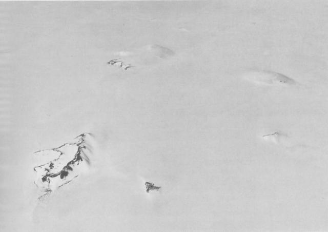
Südlicher Teil des Hudson-Gebirges mit dem Mount Manthe links oberhalb der Bildmitte (Schrägluftbild von Westen) | ||
| Höhe | 576 m | |
| Lage | Ellsworthland, Westantarktika | |
| Gebirge | Hudson-Gebirge | |
| Koordinaten | 74° 47′ 0″ S, 99° 21′ 0″ W | |
| ||
| Typ | Schichtvulkan | |
| Alter des Gesteins | Miozän | |

Luftaufnahmen der United States Navy, die bei der Operation Highjump (1946–1947) entstanden, dienten seiner Kartierung. Das Advisory Committee on Antarctic Names benannte ihn 1968 nach Lawrene L. Manthe (1938–2007), Meteorologe auf der Byrd-Station im antarktischen Winter 1967.
Weblinks
- Hudson Mountains im Global Volcanism Program der Smithsonian Institution (englisch).
- Antarctica Detail – Mount Manthe im Geographic Names Information System des United States Geological Survey (englisch).
- Geographical Names – Manthe, Mount, Antarctica. In: geographic.org. (englisch).
На других языках
- [de] Mount Manthe
[en] Mount Manthe
Mount Manthe (74°47′S 99°21′W) is a mountain 575 metres (1,890 ft) high standing 5 nautical miles (9 km) north-northeast of Shepherd Dome, in the southern part of the Hudson Mountains, Antarctica. It was mapped from air photos taken by U.S. Navy Operation Highjump in 1946–47, and was named by the Advisory Committee on Antarctic Names for Lawrene L. Manthe, a meteorologist at Byrd Station in 1967.[1]Текст в блоке "Читать" взят с сайта "Википедия" и доступен по лицензии Creative Commons Attribution-ShareAlike; в отдельных случаях могут действовать дополнительные условия.
Другой контент может иметь иную лицензию. Перед использованием материалов сайта WikiSort.org внимательно изучите правила лицензирования конкретных элементов наполнения сайта.
Другой контент может иметь иную лицензию. Перед использованием материалов сайта WikiSort.org внимательно изучите правила лицензирования конкретных элементов наполнения сайта.
2019-2026
WikiSort.org - проект по пересортировке и дополнению контента Википедии
WikiSort.org - проект по пересортировке и дополнению контента Википедии