geo.wikisort.org - Bergen
Die Lichen Hills (englisch für Flechtenhügel) sind eine Hügelkette in Form einer Geländestufe im ostantarktischen Viktorialand. Sie ragen 3 km südlich der Caudal Hills am Westrand des Rennick-Gletschers auf.
| Lichen Hills | ||
|---|---|---|
| Lage | Viktorialand, Ostantarktika | |
| Teil des | Transantarktischen Gebirges | |
| ||
| Koordinaten | 73° 18′ S, 162° 0′ O | |

Die Nordgruppe der New Zealand Geological Survey Antarctic Expedition (1962–1963) kartierte sie und benannte sie nach den hier gefundenen Flechten.
Weblinks
- Lichen Hills im Geographic Names Information System des United States Geological Survey (englisch)
- Lichen Hills auf geographic.org (englisch)
 Lichen Hills am östlichen Kartenrand nördlich der Mitte
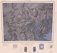 Lichen Hills am westlichen Kartenrand nördlich der Mitte


На других языках
- [de] Lichen Hills
[en] Lichen Hills
The Lichen Hills (.mw-parser-output .geo-default,.mw-parser-output .geo-dms,.mw-parser-output .geo-dec{display:inline}.mw-parser-output .geo-nondefault,.mw-parser-output .geo-multi-punct{display:none}.mw-parser-output .longitude,.mw-parser-output .latitude{white-space:nowrap}73°18′S 162°0′E) are an escarpment-like range of hills located 2 nautical miles (4 km) south of the Caudal Hills on the west margin of upper Rennick Glacier, in Victoria Land, Antarctica. Its north end forms Section Peak. Lichens were collected there, hence the name given by the northern party of the New Zealand Geological Survey Antarctic Expedition, 1962–63.[1]Текст в блоке "Читать" взят с сайта "Википедия" и доступен по лицензии Creative Commons Attribution-ShareAlike; в отдельных случаях могут действовать дополнительные условия.
Другой контент может иметь иную лицензию. Перед использованием материалов сайта WikiSort.org внимательно изучите правила лицензирования конкретных элементов наполнения сайта.
Другой контент может иметь иную лицензию. Перед использованием материалов сайта WikiSort.org внимательно изучите правила лицензирования конкретных элементов наполнения сайта.
2019-2026
WikiSort.org - проект по пересортировке и дополнению контента Википедии
WikiSort.org - проект по пересортировке и дополнению контента Википедии