geo.wikisort.org - Остров
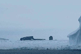
Остров Скотта (англ. Scott Island) — остров в южной части Тихого океана, у берегов Антарктиды, примерно в 600 км от мыса Адэр (северо-восточная оконечность Земли Виктории).
| Остров Скотта | |
|---|---|
| англ. Scott Island | |
 Остров Скотта и скала Хаггитс-Пиллар | |
| Характеристики | |
| Площадь | 0,04 км² |
| Наивысшая точка | 54 м |
| Население | 0 чел. (2012) |
| Расположение | |
| 67°24′05″ ю. ш. 179°55′00″ з. д.HGЯO | |
| Акватория | Южный океан |
| Континент |
|
География

Длина острова составляет 565 м, ширина — до 340 м, высота 54 м. Сложен базальтами; поверхность почти полностью скрыта подо льдом. В 250 м западнее расположена скала Хаггитс-Пиллар диаметром около 50 м и высотой 62 м.
История
Остров был открыт в 1902 году капитаном экспедиционного судна британской антарктической экспедиции Уильмом Колбеком и назван в честь Роберта Скотта.
Источники
- Остров Скотта — статья из Большой советской энциклопедии.
В статье есть список источников, но не хватает сносок. |
На других языках
[de] Scott-Insel
Die Scott-Insel (engl. Scott Island) ist eine vier Hektar große Insel nördlich des Rossmeers im pazifischen Sektor des Südlichen Ozeans.[en] Scott Island
Scott Island is a small uninhabited island of volcanic origin in the Ross Sea, Southern Ocean, 505 kilometres (310 mi) northeast of Cape Adare, the northeastern extremity of Victoria Land, Antarctica. It is 565 metres (618 yd) long north–south, and between 130 metres (140 yd) and 340 metres (370 yd) wide, reaching a height of 54 metres (177 ft) and covering an area of 4 hectares (9.9 acres). Haggits Pillar, a stack reaching 62 metres (203 ft) in height and measuring 50 metres (55 yd) in diameter, yielding an area of less than 0.2 hectares (0.5 acres), is located 250 metres (270 yd) west of the island. The island has two small coves with beaches, the rest of the island being surrounded by high cliffs. One of the coves is on the northeastern coast and the other opposite Haggitts Pillar on the western coast of the island.[es] Isla Scott
La isla Scott (67°24′S 179°55′O) es una pequeña isla deshabitada de origen volcánico situada en el océano Antártico, a unos 505 km al noreste del cabo Adare, la extremidad noreste de la Tierra de Victoria. Tiene 370 metros de largo y 180 m ancho, cubriendo un área de 0,04 km². Al oeste de la isla, a unos 250 m está el Pilar de Haggitt, una columna de 60 m de altura. La isla tiene dos pequeñas ensenadas con playas, el resto de la isla es rocosa. Una de las ensenadas está sobre la costa noreste y la otra en la costa occidental de la isla, enfrente al Pilar de Haggitt.[fr] Île Scott
L’île Scott est un îlot inhabité d’origine volcanique de l’océan Austral. Elle se situe à 505 km au nord-est de cap Adare, l’extrémité nord-est de la Terre Victoria.[it] Isola Scott
L'Isola Scott (67º24´S 179º55´W) è una piccola isola disabitata di origine vulcanica dell'Oceano Meridionale, 505 km a nord-est di Cape Adare, l'estremità nord-orientale della Terra della regina Victoria. È lunga 370 metri e larga 180 m, e copre un'area di 0,04 km², con il punto più elevato, l'Haggits Pillar a 63 m s.l.m.- [ru] Остров Скотта
Текст в блоке "Читать" взят с сайта "Википедия" и доступен по лицензии Creative Commons Attribution-ShareAlike; в отдельных случаях могут действовать дополнительные условия.
Другой контент может иметь иную лицензию. Перед использованием материалов сайта WikiSort.org внимательно изучите правила лицензирования конкретных элементов наполнения сайта.
Другой контент может иметь иную лицензию. Перед использованием материалов сайта WikiSort.org внимательно изучите правила лицензирования конкретных элементов наполнения сайта.
2019-2025
WikiSort.org - проект по пересортировке и дополнению контента Википедии
WikiSort.org - проект по пересортировке и дополнению контента Википедии
