geo.wikisort.org - Остров
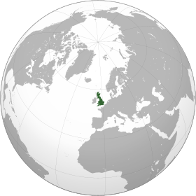
Великобрита́ния (англ. Great Britain, валл. Prydain Fawr, гэльск. Breatainn Mhòr, корнск. Breten Veur, скотс Great Breetain) — крупнейший остров в Европе и седьмой по площади в мире. Площадь его составляет 229 946 км², чуть больше острова Хонсю. Протяжённость острова с севера на юг — около 1440 км. С населением около 67 млн человек занимает третье место в мире после Явы и Хонсю. Входит в состав Британских островов. На острове расположено до 95 % территории Соединённого Королевства, в частности, основные территории Англии, Шотландии и Уэльса[1].
| Великобритания | |
|---|---|
| англ. Great Britain, скотс. Great Breetain, валл. Prydain Fawr, гэльск. Breatainn Mhòr, корнск. Breten Veur | |
 | |
| Характеристики | |
| Площадь | 229 946 км² |
| Наивысшая точка | 1344 м |
| Население | 67 081 000 чел. (2021) |
| Плотность населения | 291,73 чел./км² |
| Расположение | |
| 54°04′00″ с. ш. 2°37′00″ з. д.HGЯO | |
| Архипелаг | Британские острова |
| Омывающие акватории | Атлантический океан, Северное море |
| Страна |
|
| Регионы | Англия, Шотландия, Уэльс |

Крайние точки:
- на севере — мыс Даннет-Хед 58°40′00″ с. ш. 3°22′00″ з. д.HGЯO
- на западе — мыс Коррахад-Мор 56°42′56″ с. ш. 6°13′41″ з. д.HGЯO
- на юге — мыс Лизард (англ. The Lizard) 49°57′33″ с. ш. 5°12′54″ з. д.HGЯO
- на востоке — мыс Лоустофт-Несс 52°28′52″ с. ш. 1°45′46″ в. д.HGЯO.
Остров омывается водами Атлантического океана. Отделён мелководным Северным морем от Норвегии и Дании, узкими проливами Ла-Манш и Па-де-Кале — от Франции, Ирландским морем, проливом Святого Георга и Северным проливом — от острова Ирландия. Современные очертания его береговой линии сложились сравнительно недавно; она сильно расчленена заливами: фьордами на севере и речными эстуариями на юге[2].
На юге рельеф острова большей частью равнинный. В Уэльсе расположены Кембрийские горы высотой до 1085 м (гора Сноудон, если понимать ороним «Кембрийские горы» в широком смысле). На севере Англии расположены Пеннинские горы (до 893 м, Кросс-Фелл), переходящие на западе в Камберлендские горы (до 978 м, Пайк), и в Южно-Шотландскую возвышенность (до 843 м, Меррик) — на севере. Последняя отделена Среднешотландской низменностью от Северо-Шотландского нагорья с высочайшими горами страны Бен-Невис (1344 м) и Бен-Макдуи (1309 м)[2].
Длиннейшими реками Великобритании являются Северн (354 км) и Темза (334 км), крупнейшими озёрами — Лох-Ломонд (71 км²) и Лох-Несс (56 км²), самыми большими полуостровами — Уэльс и Корнуолл[2].
См. также
- География Великобритании
- Список островов Британских островов
- Список островов по площади
Примечания
- Great Britain | island, Europe | Britannica (англ.). www.britannica.com. Дата обращения: 7 октября 2022.
- ВЕЛИКОБРИТАНИЯ • Большая российская энциклопедия - электронная версия. bigenc.ru. Дата обращения: 7 октября 2022.
Литература
- Pliny the Elder. Natural History (англ.) / Translated by Rackham, Harris). — Harvard University Press, 1938.
- Ball, Martin John. The Celtic Languages (англ.). — Routledge, 1994. — ISBN 978-0-415-01035-1.
- Butler, Alban Butler's Lives of the Saints (англ.). — Continuum International Publishing Group, 1997. — ISBN 978-0-86012-255-5.
- Frodin, D. G. Guide to Standard Floras of the World (англ.). — Cambridge University Press, 2001. — ISBN 978-0-521-79077-2.
- Andrews, Robert. The Rough Guide to Britain (англ.). — Rough Guides, 2004. — ISBN 978-1-84353-301-6.
- Dawkins, Peter. The Shakespeare Enigma (англ.). — Polair Publishing, 2004. — ISBN 978-0-9545389-4-1.
- Major, John. History in Quotations (англ.). — Cassell, 2004. — ISBN 978-0-304-35387-3.
- Else, David. Great Britain (англ.). — Lonely Planet, 2005. — ISBN 978-1-74059-921-4.
- Kaufman, Will; Slettedahl, Heidi Macpherson. Britain and the Americas: Culture, Politics, and History (англ.). — ABC-CLIO, 2005. — ISBN 978-1-85109-431-8.
- Oppenheimer, Stephen. Origins of the British (англ.). — Carroll & Graf Publishers, 2006. — ISBN 978-0-7867-1890-0.
- Taylor, Isaac. Names and Their Histories: A Handbook of Historical Geography and Topographical Nomenclature (англ.). — BiblioBazaar, 2008. — ISBN 978-0-559-29667-3.
- Legon, N.W.; Henrici, A. Checklist of the British & Irish Basidiomycota (англ.). — Royal Botanic Gardens, Kew, 2005. — ISBN 978-1-84246-121-1.
- Cannon, P.F.; Hawksworth, D.L.; M.A., Sherwood-Pike. The British Ascomycotina. An Annotated Checklist (англ.). — Commonwealth Mycological Institute & British Mycological Society, 1985. — ISBN 978-0-85198-546-6.
Ссылки
- Interactive map of Great Britain (англ.). learningobjects.wesleyan.edu. Дата обращения: 27 декабря 2013. Архивировано 27 декабря 2013 года.
- Coast (англ.). www.bbc.co.uk. Дата обращения: 12 октября 2022.
- The British Isles (англ.). www.macs.hw.ac.uk. Дата обращения: 12 октября 2022.
- 200 Major Towns and Cities in the British Isles (англ.). www.200towns.co.uk. Дата обращения: 12 октября 2022.
- CIA Factbook United Kingdom (англ.). www.cia.gov. Дата обращения: 7 января 2019. Архивировано 7 января 2019 года.
| В библиографических каталогах |
|
|---|
На других языках
[de] Großbritannien (Insel)
Die Insel Großbritannien liegt im Atlantischen Ozean, zwischen der Irischen See und dem Nordatlantik im Westen, der Nordsee im Osten und dem Ärmelkanal im Südosten, an der nordwestlichen Küste des europäischen Kontinents.[2][en] Great Britain
Great Britain is an island in the North Atlantic Ocean off the northwest coast of continental Europe. With an area of 209,331 km2 (80,823 sq mi), it is the largest of the British Isles, the largest European island and the ninth-largest island in the world.[6][note 1] It is dominated by a maritime climate with narrow temperature differences between seasons. The 60% smaller island of Ireland is to the west—together with these islands, along with over 1,000 smaller surrounding islands and named substantial rocks, form the British Isles archipelago.[8][es] Gran Bretaña
Gran Bretaña es una isla situada en el océano Atlántico norte frente a la costa noroeste de la Europa continental. Es la mayor isla del archipiélago de las islas británicas.[1] Su superficie es de 209 331 km², siendo la mayor isla de Europa, la novena mayor del mundo y es —después de Java (Indonesia) y Honshu (Japón)— la tercera más poblada del planeta. El territorio de Gran Bretaña está formado por tres naciones: Inglaterra, Gales y Escocia, que forman parte del Reino Unido de Gran Bretaña e Irlanda del Norte.[fr] Grande-Bretagne
La Grande-Bretagne (en anglais : Great Britain ou plus rarement Britain, en gallois : Prydain Fawr, en scots : Great Breetain, en cornique : Breten Veur, en gaélique écossais : Breatainn Mhòr) est une île au large du littoral nord-ouest de l'Europe continentale. Elle représente la majorité du territoire du Royaume-Uni. En son acception politique, ce toponyme désigne l'Angleterre, le pays de Galles et l'Écosse ainsi que la plupart des territoires insulaires contigus à l'exclusion de l'Île de Man et des Îles Anglo-Normandes.[it] Gran Bretagna
La Gran Bretagna (in inglese Great Britain o più familiarmente Britain; in scots Great Breetain; in gaelico scozzese Breatainn Mhór; in gallese Prydain Fawr; in cornico Breten Veur; in italiano, anticamente, Britannia e Albione) è un'isola europea dell'oceano Atlantico situata a nordovest dell'Europa continentale. Si sviluppa per circa 900 km in direzione nord-sud e presenta un'estensione massima di circa 460 km in direzione est-ovest; la sua distanza minima dal continente, da cui è separata dal canale della Manica, è di 34 km presso lo stretto di Dover, che divide l'isola dalla Francia.- [ru] Великобритания (остров)
Другой контент может иметь иную лицензию. Перед использованием материалов сайта WikiSort.org внимательно изучите правила лицензирования конкретных элементов наполнения сайта.
WikiSort.org - проект по пересортировке и дополнению контента Википедии