geo.wikisort.org - Isola
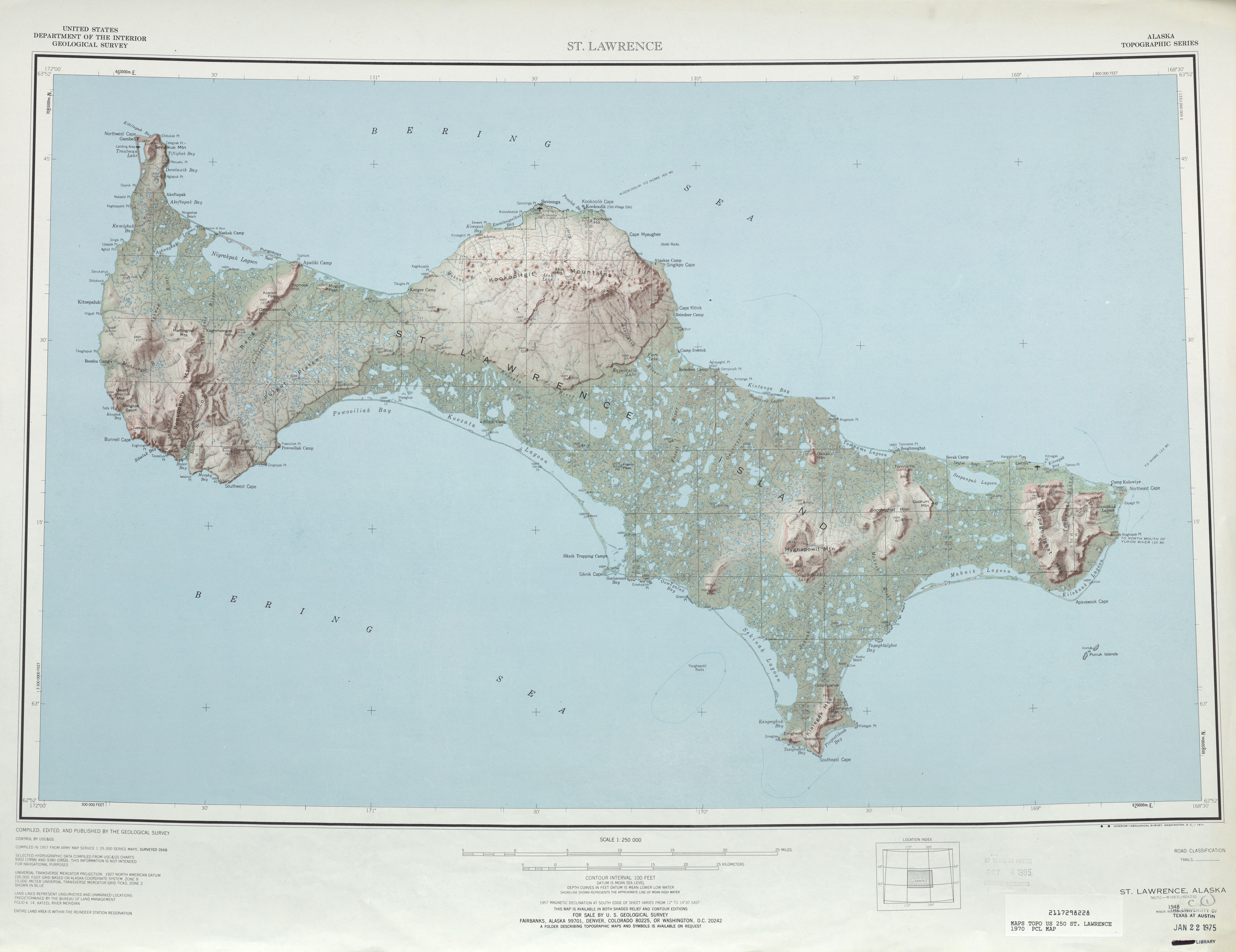
L'isola di San Lorenzo (St. Lawrence Island) si trova ad ovest dell'Alaska (Stati Uniti d'America) nel mare di Bering, fa parte dell'Alaska anche se è più vicina alla Russia.
| Isola di San Lorenzo | |
|---|---|
 | |
| Geografia fisica | |
| Localizzazione | Mare di Bering |
| Coordinate | 63°21′44″N 170°16′02″W |
| Superficie | 4.640 km² |
| Dimensioni | 145 × 36 km |
| Altitudine massima | monte Atouk 631 m s.l.m. |
| Geografia politica | |
| Stato | |
| Stato federato | |
| Centro principale | Gambell |
| Demografia | |
| Abitanti | 1.352 (2010) |
| Cartografia | |
 | |
 Isola di San Lorenzo | |
fonte missouri.edu[1] | |
| voci di isole degli Stati Uniti d'America presenti su Wikipedia | |
Geografia
L'isola fa parte della Census Area di Nome; lunga 145 km e larga dai 13 ai 36 km, con una superficie complessiva di 4.640 km², è la 6ª isola degli Stati Uniti per dimensione e la 113ª al mondo. Non ha alberi e la sola pianta legnosa presente è il salice artico che riesce a crescere solo circa fino a 30 cm. Nell'isola abbondano però gli uccelli marini e alcuni mammiferi marini soprattutto grazie alla corrente di Anadyr, fredda e ricca di nutrienti. Secondo il censimento del 2010 nell'isola abitano circa 1.352 persone.
Storia
L'isola veniva chiamata Sivuqaq dagli Yupik che ci vivevano; ha preso poi il nome moderno dall'esploratore russo/danese Vitus Bering che la visitò proprio il giorno di San Lorenzo, il 10 agosto, nel 1728. L'isola è stato il primo posto in Alaska ad esser visitato da esploratori europei.
Note
- Museum of Anthropology - St. Lawrence Island and the Bering Strait Region Archiviato il 24 giugno 2011 in Internet Archive.
- U.S. Census Bureau Archiviato il 12 febbraio 2020 in Archive.is.
Voci correlate
- Lista di isole per area
Altri progetti
 Wikimedia Commons contiene immagini o altri file su Isola di San Lorenzo
Collegamenti esterni
- Archaeology of the Tundra and Arctic Alaska, su nps.gov.
| Controllo di autorità | VIAF (EN) 248111236 · LCCN (EN) sh86000467 · GND (DE) 4105201-8 · J9U (EN, HE) 987007539070605171 · WorldCat Identities (EN) viaf-248111236 |
|---|
На других языках
[de] Sankt-Lorenz-Insel
Die Sankt-Lorenz-Insel (englisch St. Lawrence Island, Yupik-Sprache: Sivuqaq) liegt inmitten der Beringsee etwa 250 km südwestlich der Westspitze von Alaska und knapp 100 km vor der Ostspitze Russlands.[en] St. Lawrence Island
St. Lawrence Island (Central Siberian Yupik: Sivuqaq, Russian: Остров Святого Лаврентия, romanized: Ostrov Svyatogo Lavrentiya) is located west of mainland Alaska in the Bering Sea, just south of the Bering Strait. The village of Gambell, located on the northwest cape of the island, is 50 nautical miles (95 kilometers) from the Chukchi Peninsula in the Russian Far East. The island is part of Alaska, but closer to Russia than to the Alaskan mainland. St. Lawrence Island is thought to be one of the last exposed portions of the land bridge that once joined Asia with North America during the Pleistocene period.[1] It is the sixth largest island in the United States and the 113th largest island in the world. It is considered part of the Bering Sea Volcanic Province.[2] The Saint Lawrence Island shrew (Sorex jacksoni) is a species of shrew endemic to St. Lawrence Island.[3][es] Isla San Lorenzo (Alaska)
La isla San Lorenzo (en inglés, St. Lawrence Island; en yupik, Sivuqaq) es una isla en el mar de Bering situada al oeste de la península de Alaska, al sur del estrecho de Bering. Forma parte del estado de Alaska, pero está más cerca de la costa rusa que de la parte continental de Alaska. La isla San Lorenzo se piensa que es una de las últimas porciones expuestas del puente de tierra que una vez unió a Asia con América del Norte durante el período del Pleistoceno.[1] Por superficie, es la sexta isla más grande de los Estados Unidos y la 122 ªdel mundo.[fr] Île Saint-Laurent
L'île Saint-Laurent (en anglais : St. Lawrence Island ; en yupik sibérien central : Sivuqaq ; en russe : Остров Святого Лаврентия) est située dans la mer de Béring et au sud du détroit de même nom, à l'ouest de l'Alaska, à environ 64° nord, 170° 28' ouest. Bien que territoire de l'Alaska, elle est géographiquement plus proche de la Russie (elle en est séparée de 74 kilomètres, contre 187 de l'Alaska). L'île Saint-Laurent est considérée comme l'une des portions non immergées de l'ancien pont terrestre de Béringie qui reliait l'Asie à l'Amérique du Nord durant le Pléistocène[1].- [it] Isola di San Lorenzo
[ru] Остров Святого Лаврентия
Остров Святого Лаврентия (англ. St. Lawrence Island, эским. Сивуӄаӄ, Sivuqaq) — остров в южной части Берингова пролива, в 80 км от полуострова Чукотка (мыс Чаплина). Административно является частью штата Аляска, хотя и находится ближе к Чукотскому полуострову, чем к Аляске. Считается, что остров представляет собой последний оставшийся над уровнем моря фрагмент перешейка, соединявшего в эпоху плейстоцена Евразию и Америку[1]. Это шестой по величине остров в Соединённых Штатах (англ.) (рус. и 114-й по величине остров в мире.Другой контент может иметь иную лицензию. Перед использованием материалов сайта WikiSort.org внимательно изучите правила лицензирования конкретных элементов наполнения сайта.
WikiSort.org - проект по пересортировке и дополнению контента Википедии