geo.wikisort.org - Insel
Die Sankt-Lorenz-Insel (englisch St. Lawrence Island, Yupik-Sprache: Sivuqaq) liegt inmitten der Beringsee etwa 250 km südwestlich der Westspitze von Alaska und knapp 100 km vor der Ostspitze Russlands.
| Sankt-Lorenz-Insel | ||
|---|---|---|
 | ||
| Gewässer | Beringmeer | |
| Geographische Lage | 63° 25′ N, 170° 24′ W | |
| ||
| Länge | 145 km | |
| Breite | 36 km | |
| Fläche | 4 640,1 km² | |
| Höchste Erhebung | Atuk Mountain 631 m | |
| Einwohner | 1292 (2000) <1 Einw./km² | |
| Hauptort | Gambell | |
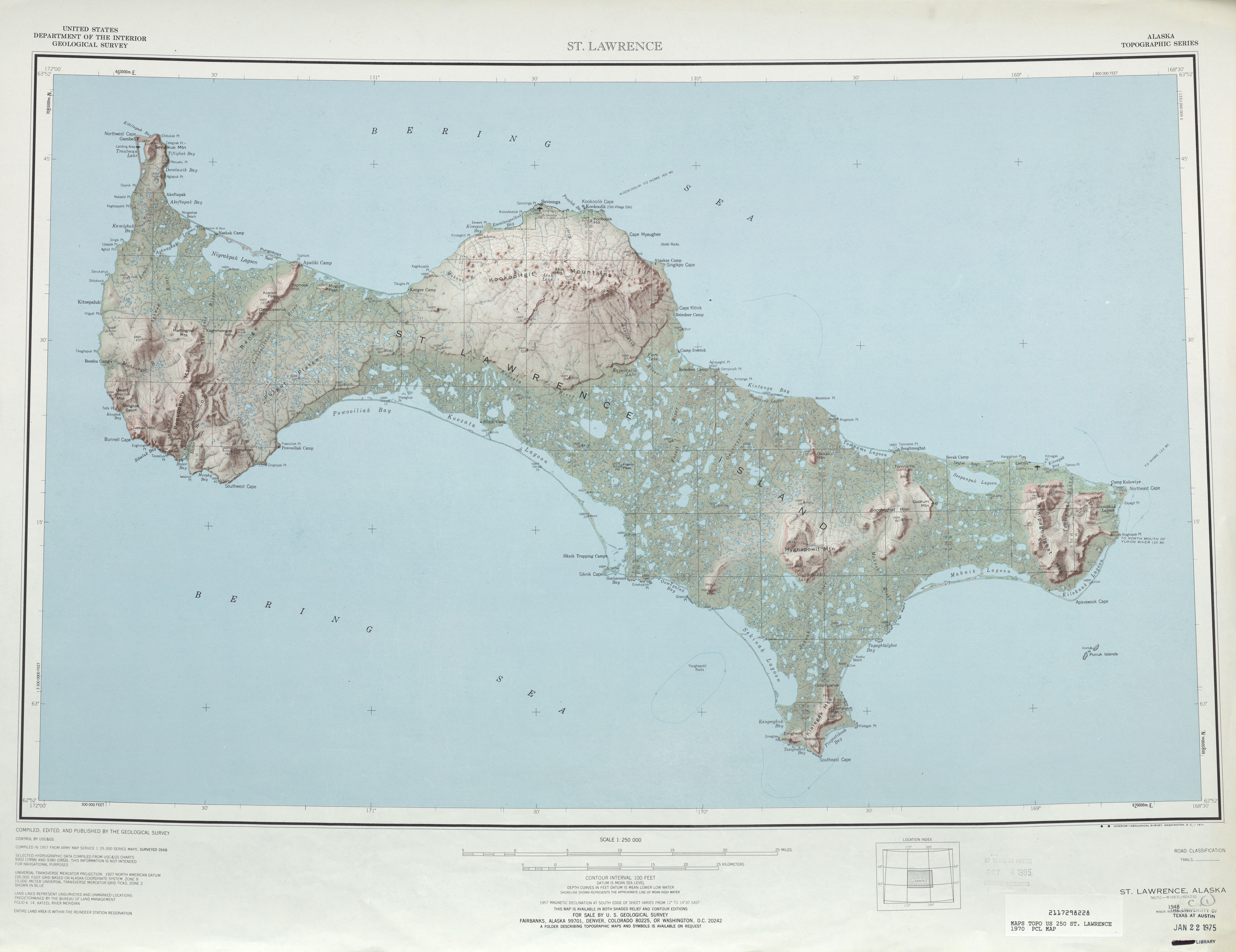 | ||

Die zum US-Bundesstaat Alaska gehörende, baumlose Insel ist 140 km lang und zwischen 13 und 35 Kilometer breit. Mit 4640 km² Landfläche ist sie die größte Insel im Beringmeer.[1] Den höchsten Punkt bildet der 631 m hohe Mount Atok.
Auf St. Lorenz leben heute etwa 1300 Yupik,[2] überwiegend in den Hauptorten Gambell im Nordwesten und Savoonga an der Nordküste der Insel.
Der in russischen Diensten stehende dänische Marineoffizier Vitus Bering entdeckte die Insel am 21. August 1728 (neuen Stils). Im Schiffstagebuch wurde die Entdeckung auf Samstag, den 10. August (alten Stils) datiert.[3] Er benannte die Insel deshalb zu Ehren des an diesem Tag im Jahre 258 verstorbenen christlichen Märtyrers Laurentius von Rom (Lorenz/Lawrence).
Zur Fauna der Insel gehören unter anderem der Schopfalk, ein mittelgroßer Vogel aus der Familie der Alkenvögel. Auf der Insel befindet sich eine der bedeutenderen Brutkolonien dieser Art.[4] Auch der Zwergalk, der kleinste Alkenvogel, ist ein Brutvogel dieser Insel.[5]
- Ansichten
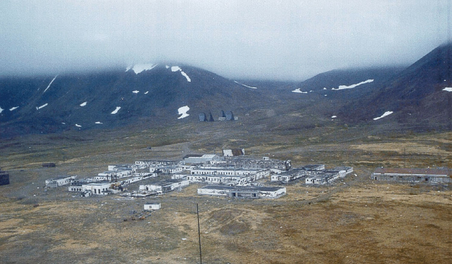
 Die frühere Northeast Cape Air Force Station
 Luftbild des Ortes Gambell
 Satellitenbild der Insel


Weblinks
Einzelnachweise
- St Lawrence Island (Alaska) cruisemapper.com, abgerufen am 2. November 2017.
- Block Group 6, Census Tract 1, Nome Census Area, Alaska American Fact Finder, abgerufen am 2. November 2017. (englisch)
- Die Datierung im Schiffstagebuch berücksichtigt nicht das Kreuzen der Datumsgrenze. In Nordamerika war es noch Freitag.
- Anthony J. Gaston und Ian L. Jones: The Auks. Oxford University Press, Oxford 1998, ISBN 0-19-854032-9, S. 245
- Anthony J. Gaston und Ian L. Jones: The Auks. Oxford University Press, Oxford 1998, ISBN 0-19-854032-9, S. 257.
На других языках
- [de] Sankt-Lorenz-Insel
[en] St. Lawrence Island
St. Lawrence Island (Central Siberian Yupik: Sivuqaq, Russian: Остров Святого Лаврентия, romanized: Ostrov Svyatogo Lavrentiya) is located west of mainland Alaska in the Bering Sea, just south of the Bering Strait. The village of Gambell, located on the northwest cape of the island, is 36 miles (58 kilometers) from the Chukchi Peninsula in the Russian Far East. The island is part of Alaska, but closer to Russia than to the Alaskan mainland. St. Lawrence Island is thought to be one of the last exposed portions of the land bridge that once joined Asia with North America during the Pleistocene period.[1] It is the sixth largest island in the United States and the 113th largest island in the world. It is considered part of the Bering Sea Volcanic Province.[2] The Saint Lawrence Island shrew (Sorex jacksoni) is a species of mammal in the family Soricidae found only on St. Lawrence Island.[3][fr] Île Saint-Laurent
L'île Saint-Laurent (en anglais : St. Lawrence Island ; en yupik sibérien central : Sivuqaq ; en russe : Остров Святого Лаврентия) est située dans la mer de Béring et au sud du détroit de même nom, à l'ouest de l'Alaska, à environ 64° nord, 170° 28' ouest. Bien que territoire de l'Alaska, elle est géographiquement plus proche de la Russie (elle en est séparée de 74 kilomètres, contre 187 de l'Alaska). L'île Saint-Laurent est considérée comme l'une des portions non immergées de l'ancien pont terrestre de Béringie qui reliait l'Asie à l'Amérique du Nord durant le Pléistocène[1].[it] Isola di San Lorenzo
L'isola di San Lorenzo (St. Lawrence Island) si trova ad ovest dell'Alaska (Stati Uniti d'America) nel mare di Bering, fa parte dell'Alaska anche se è più vicina alla Russia.[ru] Остров Святого Лаврентия
Остров Святого Лаврентия (англ. St. Lawrence Island, эским. Сивуӄаӄ, Sivuqaq) — остров в южной части Берингова пролива, в 80 км от полуострова Чукотка (мыс Чаплина). Административно является частью штата Аляска, хотя и находится ближе к Чукотскому полуострову, чем к Аляске. Считается, что остров представляет собой последний оставшийся над уровнем моря фрагмент перешейка, соединявшего в эпоху плейстоцена Евразию и Америку[1]. Это шестой по величине остров в Соединённых Штатах (англ.) (рус. и 114-й по величине остров в мире.Другой контент может иметь иную лицензию. Перед использованием материалов сайта WikiSort.org внимательно изучите правила лицензирования конкретных элементов наполнения сайта.
WikiSort.org - проект по пересортировке и дополнению контента Википедии