geo.wikisort.org - Isola
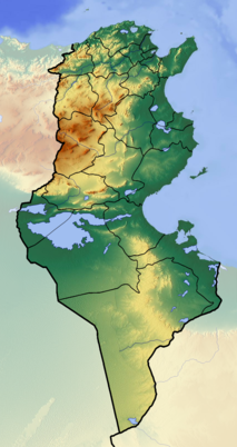
L'isola Piana (in arabo الجزيرة المنبسطة) è un'isola rocciosa a nord della Tunisia.
| Isola Piana الجزيرة المنبسطة | |
|---|---|
| Geografia fisica | |
| Localizzazione | Mar Mediterraneo |
| Coordinate | 37°10′54″N 10°19′40″E |
| Altitudine massima | 8 m s.l.m. |
| Geografia politica | |
| Stato | |
| Governatorato | Biserta |
| Cartografia | |
| voci di isole della Tunisia presenti su Wikipedia | |
Si trova nel prolungamento di Capo Sidi Ali El Mekki, più precisamente a 2,3 miglia dalla costa. È un altopiano che sorge a 8 metri sul livello del mare e ospita un edificio della marina nazionale tunisina e un faro alto 12 metri.
Storia
L'isola Piana è probabilmente la "Terapse"[1] o la Phalans Insula degli antichi geografi.[2]
Durante le guerre napoleoniche, un errore nella navigazione fece naufragare il capitano Charles Tyler della fregata Aigle catturata nell'isola Piana nel luglio 1798[3] mentre operava contro i francesi e i pirati nell'area. Tutto l'equipaggio fu salvato e il capitano Tyler non fu ritenuto responsabile per la perdita.[4]
Dopo l'istituzione del controllo francese sulla Tunisia, Ernest Cosson studiò la vita vegetale sull'isola Piana nel maggio 1888.[5]
La nave belga Scheldepas si incagliò al largo dell'isola il 14 marzo 1929. L'equipaggio fu salvato dalla nave britannica Tabarka.[6][7] La nave greca Michael L. Embricios si incagliò sull'isola il 22 novembre 1931. 30 membri dell'equipaggio furono salvati dalla nave tedesca Alaya.[8]
Le rotte marittime intorno all'isola Piana furono minate dagli Alleati durante la seconda guerra mondiale.[9] Come parte dell'Operazione Retribution, il blocco alleato dell'Asse tentò di fuggire dalla Tunisia alla Sicilia. La nave HMS Lookout catturò 13 tedeschi e italiani al largo dell'Isola Piana il 13 maggio 1943. Poco dopo, l'HMS Laforey, in rotta dalle riparazioni a Malta, si fermò sull'isola Piana, scoprendo 23 soldati dell'Asse e facendoli prigionieri.
Faro
Il faro dell'isola eretta dalle autorità coloniali francesi nel 1888. È una torre quadrata a fasce bianche e rosse, che si innalza dalla casa del suo custode. La torre è alta 12 metri (39 piedi). La sua lanterna rossa rimane in uso. Lampeggia due volte ogni 10 secondi con un'altezza del piano focale di 20 metri (65 piedi); è visibile per 20-28 chilometri.[10]
Trasporti
L'isola rimane accessibile solo in barca. Risulta chiusa al pubblico accesso.[10]
Note
- (EN) Catalogue of ancient coastal settlements, ports and harbours, su ancientportsantiques.com, 6 luglio 2011. URL consultato il 18 gennaio 2021.
- (EN) Ancient ports antiques North Africa Tunisia Algeria Morocco | Ancient Ports - Ports Antiques, su ancientportsantiques.com, 6 luglio 2011. URL consultato il 18 gennaio 2021.
- Nicholas (1997), p. 103.
- Hepper (1994), p. 87.
- SSNT (1967), p. 109.
- "Casualty Reports", The Times, No. 45143, London, 16 March 1929, p. 22.
- SS Scheldepas (+1929)"". wrecksite.eu.
- "Casualty Reports", The Times, No. 45987, London, 23 November 1931, pp. 20,21,23-
- Playfair & al. (1966), p. 249.
- Lighthouse webmaster - Geoffrey Baker - info@lhdigest.com, Foghorn Publishing ... Lighthouse Explorer Database ... Ile Plane Light, su lighthousedigest.com. URL consultato il 18 gennaio 2021.
Bibliografia
- Bulletin, Vols. 6–8, Société des Sciences Naturelles de Tunisie, 1967. (in francese)
- Francalanci, Giampiero; et al., eds. (1994), Lines in the Sea, Dordrecht: Martinus Nijhoff Publishers.
- Hepper, David (1994), British Warship Losses in the Age of Sail, 1650–1859, Rotherfield: Jean Boudriot, ISBN 0-948864-30-3.
- Nelson, Horatio (1997), Nicolas, Nicholas Harris (ed.), The Dispatches and Letters of Lord Nelson, III, Chatham.
- Playfair, Ian Stanley Ord; et al. (1966), The History of the Second World War: The Mediterranean and the Middle East, IV, London: Her Majesty's Stationery Office.
- Taylor, Alfred Dundas (1874), The India Directory..., Pt. I: The East Indies, and Interjacent Ports of Africa and South America..., London: Wm. H. Allen & Co.
Altri progetti
 Wikimedia Commons contiene immagini o altri file su Isola Piana (Tunisia)
| Controllo di autorità | VIAF (EN) 91148570690024312023 |
|---|
На других языках
[en] Plane Island
Plane Island (French: Île Plane; Latin: Phalans Insula) also known as Piana[1] or Plana Island[2] and—in Tunisian Arabic—as Jaziret el-Monbasta[3] (Standard Arabic: الجزيرة المنبسطة, Jazirat al-Mussattahah), is a flat, rocky island in the Mediterranean Sea roughly 3.75 kilometers (2.3 mi) off Cape Farina, Tunisia.[4] It has a lighthouse.[fr] Île Plane (Tunisie)
L'île Plane (arabe : الجزيرة المنبسطة) est une île rocheuse située au nord de la Tunisie.- [it] Isola Piana (Tunisia)
[ru] План (остров, Тунис)
План[1][2] (араб. الجزيرة المنبسطة, фр. Île Plane) — остров на севере Туниса, в западной части Тунисского залива. Расположен к востоку от деревни Гар-эль-Мелах[en], острова Пило[fr] и мыса Рас-эт-Тарф[en] (Фарина). На острове расположен маяк[fr][1][2]. Относится к вилайету Бизерта.Другой контент может иметь иную лицензию. Перед использованием материалов сайта WikiSort.org внимательно изучите правила лицензирования конкретных элементов наполнения сайта.
WikiSort.org - проект по пересортировке и дополнению контента Википедии
