geo.wikisort.org - Isola
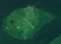
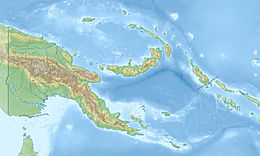
Daru è un'isola della Papua Nuova Guinea, è una delle isole dello stretto di Torres nell'omonimo stretto, e si trova a sud della Nuova Guinea. Amministrativamente fa parte del Distretto di South Fly nella Provincia Occidentale, appartenente alla Regione di Papua.
| Daru | |
|---|---|
 | |
| Geografia fisica | |
| Localizzazione | Stretto di Torres |
| Coordinate | 9°05′10″S 143°12′27″E |
| Arcipelago | Isole dello stretto di Torres |
| Superficie | 14,7 km² |
| Dimensioni | 5 × 3,7 km |
| Altitudine massima | 27 m s.l.m. |
| Geografia politica | |
| Stato | |
| Regione | Regione di Papua |
| Provincia | |
| Distretto | Distretto di South Fly |
| Centro principale | Daru |
| Fuso orario | UTC+10 |
| Demografia | |
| Abitanti | 20524 (2009) |
| Densità | 876 ab./km² |
| Cartografia | |
 Daru | |
| voci di isole della Papua Nuova Guinea presenti su Wikipedia | |
Sull'isola si trova la capitale della provincia, Daru, dove vive la maggior parte dei 20.524 isolani.
Storia
Il primo avvistamento registrato di Daru, da parte degli europei, avvenne durante la spedizione spagnola di Luis Váez de Torres il 5 settembre 1606.[1]
Note
- Hilder, Brett The voyage of Torres, Brisbane, 1980, pp.67,73
Altri progetti
 Wikimedia Commons contiene immagini o altri file su Daru
Collegamenti esterni
- (EN) Daru, su Enciclopedia Britannica, Encyclopædia Britannica, Inc.
На других языках
[en] Daru Island
Daru Island is an island in the Western Province of Papua New Guinea. It is one of the Torres Strait Islands. The eponymous town on the island is the capital of the province, and houses the vast majority of the island's population of 20,524 (2009). Daru Island is elliptical in shape, with dimensions of 5.0 by 3.7 kilometers, an area of 14.7 km², and an elevation of up to 27 m. The island is separated from the mainland in the north, specifically the mouth of Oriomo River, by the 3.5 km wide Daru Roads. The shortest distance to the larger Bristow Island (also called Bobo Island) in the south is 1.3 km.[es] Isla Daru
Isla Daru está ubicada en la Provincia Occidental de Papúa Nueva Guinea.- [it] Daru (isola)
[ru] Дару (остров)
Остров Дару (англ. Daru Island) — остров в Торресовом проливе. Является территорией государства Папуа — Новая Гвинея. Административно входит в состав Западной провинции региона Папуа. Находится недалеко от устья реки Флай в западной части залива. Площадь острова составляет 14,7 км². Население — 12 879 человек (по переписи 2000 года) живет в городе Дару. Остров является наиболее густонаселенным в Торресовом проливе.Текст в блоке "Читать" взят с сайта "Википедия" и доступен по лицензии Creative Commons Attribution-ShareAlike; в отдельных случаях могут действовать дополнительные условия.
Другой контент может иметь иную лицензию. Перед использованием материалов сайта WikiSort.org внимательно изучите правила лицензирования конкретных элементов наполнения сайта.
Другой контент может иметь иную лицензию. Перед использованием материалов сайта WikiSort.org внимательно изучите правила лицензирования конкретных элементов наполнения сайта.
2019-2026
WikiSort.org - проект по пересортировке и дополнению контента Википедии
WikiSort.org - проект по пересортировке и дополнению контента Википедии