geo.wikisort.org - Île
L’Île Visokoi est une île volcanique inhabitée des îles Sandwich du Sud. Elle fut découverte en 1819 par une expédition russe sous les ordres de Fabian Gottlieb von Bellingshausen, qui l’a nommée ainsi en raison de sa hauteur apparente (visokoi signifie « haut » en russe).
Cet article est une ébauche concernant le monde insulaire et la Géorgie du Sud-et-les îles Sandwich du Sud.
Vous pouvez partager vos connaissances en l’améliorant (comment ?) selon les recommandations des projets correspondants.
| Île Visokoi | ||
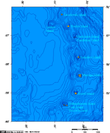
 Photo satellite de l'île Visokoi | ||
| Géographie | ||
|---|---|---|
| Pays | ||
| Revendication par | ||
| Archipel | Îles Sandwich du Sud | |
| Localisation | Océan Atlantique | |
| Coordonnées | 56° 42′ S, 27° 12′ O | |
| Superficie | 35 km2 | |
| Point culminant | Mont Hodson (915 m) | |
| Géologie | Île volcanique | |
| Administration | ||
| Territoire britannique d'outre-mer | Géorgie du Sud-et-les îles Sandwich du Sud | |
| Démographie | ||
| Population | Aucun habitant | |
| Autres informations | ||
| Découverte | 1675 | |
| Fuseau horaire | UTC-4 | |
| Géolocalisation sur la carte : Géorgie du Sud-et-les îles Sandwich du Sud
| ||
| Îles au Royaume-Uni | ||
| modifier |
||

L’île est longue de 7,2 km et large de 4,8 km, surmonté par le Mont Hodson, un volcan haut de 915 m. Le mont se nomme ainsi d’après Sir Arnold Weinholt Hodson, un gouverneur des Îles Malouines.
Voir aussi
Articles connexes
Notes et références
- (en) volcano.und.edu
 Portail de la Géorgie du Sud-et-les îles Sandwich du Sud
  Portail du monde insulaire
На других языках
[de] Visokoi Island
Visokoi Island ist eine unbewohnte Vulkaninsel des im südlichen Atlantischen Ozean gelegenen Britischen Überseegebietes „Südgeorgien und die Südlichen Sandwichinseln“.[en] Visokoi Island
Visokoi Island is an uninhabited island in the Traversay Islands group of the South Sandwich Islands. It was discovered in 1819 by a Russian expedition under Fabian Gottlieb von Bellingshausen, who initially named the island Thorson Island in honor of Lieutenant Konstantin Thorson [ru], though the tsarist government later renamed the island Visokoi ("high"), after its conspicuous height, in response to Thorson's participation in the Decembrist revolt.[1][2] The island was surveyed in 1930 by Discovery Investigations (DI) personnel, who charted and named many of its features.[3][4] Several of the names given by DI were changed in 1953 by the United Kingdom Antarctic Place-Names Committee (UK-APC) to avoid redundancy with nearby features.[3][5][es] Isla Visokoi
La isla Visokoi es una isla cubierta de hielo y de forma ovalada[1] que integra el archipiélago Marqués de Traverse, el cual a su vez forma parte de las islas Sandwich del Sur en el océano Atlántico Sur.- [fr] Île Visokoi
[it] Isola di Visokoi
Visokoi è un'isola disabitata nell'arcipelago delle Isole Traversay nelle Isole Sandwich Australi. Venne scoperta nel 1819 da una spedizione russa guidata da Fabian Gottlieb von Bellingshausen, che nominò l'isola "Visokoi" (ossia "alta") a causa della sua elevazione piuttosto cospicua per la zona.[1][ru] Высокий (остров, Южные Сандвичевы острова)
Высо́кий (англ. Visokoi Island) — небольшой необитаемый остров в архипелаге Южные Сандвичевы острова в южной части Атлантического океана. Архипелаг входит в состав заморской территории Великобритании Южная Георгия и Южные Сандвичевы Острова (то есть принадлежит Великобритании, но не являются её частью).Текст в блоке "Читать" взят с сайта "Википедия" и доступен по лицензии Creative Commons Attribution-ShareAlike; в отдельных случаях могут действовать дополнительные условия.
Другой контент может иметь иную лицензию. Перед использованием материалов сайта WikiSort.org внимательно изучите правила лицензирования конкретных элементов наполнения сайта.
Другой контент может иметь иную лицензию. Перед использованием материалов сайта WikiSort.org внимательно изучите правила лицензирования конкретных элементов наполнения сайта.
2019-2026
WikiSort.org - проект по пересортировке и дополнению контента Википедии
WikiSort.org - проект по пересортировке и дополнению контента Википедии