geo.wikisort.org - Île
L'île Haha (母島, Hahajima, litt. « île Mère ») est une île du Japon faisant partie de l'archipel d'Ogasawara (sous-préfecture d'Ogasawara de Tokyo). L'île a une superficie de 20,21 km2. En 2009, elle abritait 450 habitants.
Pour les articles homonymes, voir Haha.
Cet article est une ébauche concernant le monde insulaire et le Japon.
Vous pouvez partager vos connaissances en l’améliorant (comment ?) selon les recommandations des projets correspondants.
| Île Haha 母島 (ja) | ||
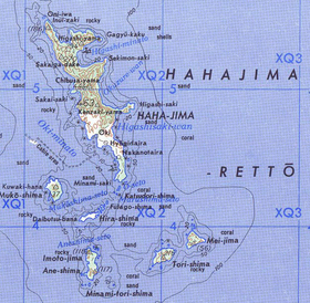 Carte de l'archipel. | ||
| Géographie | ||
|---|---|---|
| Pays | ||
| Archipel | Ogasawara | |
| Localisation | Mer des Philippines (océan Pacifique) | |
| Coordonnées | 26° 39′ 00″ N, 142° 10′ 00″ E | |
| Superficie | 20,21 km2 | |
| Point culminant | Mont Chibusa (462 m) | |
| Géologie | Île continentale | |
| Administration | ||
| Préfecture | Tokyo | |
| District | Ogasawara | |
| Démographie | ||
| Population | 450 hab. (2009) | |
| Densité | 22,27 hab./km2 | |
| Plus grande ville | Ogasawara | |
| Autres informations | ||
| Découverte | Préhistoire | |
| Fuseau horaire | UTC+09:00 | |
| Site officiel | www.hahajima.com | |
| Géolocalisation sur la carte : Japon
| ||
| Îles au Japon | ||
| modifier |
||


Voir aussi
Articles connexes
Liens externes
- (ja) Site officiel de l'île.
 Portail de Tokyo
  Portail du monde insulaire
На других языках
[de] Haha-jima
Haha-jima (jap. 母島, wörtlich: „Mutter-Insel“), auch bekannt als Coffin Island oder Hillsborough Island, ist die zweitgrößte Insel der Ogasawara-guntō (Bonininseln) in der Präfektur Tokio. Die Inselgruppe gehört seit 1876 zu Japan. Haha-jima hat eine Fläche von 19,88 km²[1] sowie 450 Einwohner. Die höchste Erhebung ist der Berg Chibusa mit etwa 462 m Höhe. Der ganz in der Nähe liegende Berg Sakaigatake ist mit 443 m nur unwesentlich niedriger.[en] Hahajima
Hahajima (母島, meaning Mother Island) is the second-largest island within the Bonin Islands (also known as the Ogasawara Islands) south of the Japan. The steeply-sloped island, which is about 21 km2 (8 sq mi) in area, has a population of 440.[1] It is part of Ogasawara Village in Ogasawara Subprefecture, which is approximately 1,000 km (620 mi) south of Tokyo, Japan.- [fr] Haha-jima
[it] Haha-jima
Haha-jima (母島? letteralmente: isola madre) è la seconda più grande delle isole Ogasawara (o isole Bonin), in Giappone, a sud dell'arcipelago principale. Ha un'area di circa 20 km2 con una popolazione di 450 abitanti.Текст в блоке "Читать" взят с сайта "Википедия" и доступен по лицензии Creative Commons Attribution-ShareAlike; в отдельных случаях могут действовать дополнительные условия.
Другой контент может иметь иную лицензию. Перед использованием материалов сайта WikiSort.org внимательно изучите правила лицензирования конкретных элементов наполнения сайта.
Другой контент может иметь иную лицензию. Перед использованием материалов сайта WikiSort.org внимательно изучите правила лицензирования конкретных элементов наполнения сайта.
2019-2026
WikiSort.org - проект по пересортировке и дополнению контента Википедии
WikiSort.org - проект по пересортировке и дополнению контента Википедии