geo.wikisort.org - Île
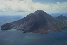
Banda Api est une île volcanique des îles Banda, en Indonésie. Son volcan, le Gunung Api, est actif et culmine à 640 mètres. Sa dernière éruption date de 1988.
| Banda Api | ||
 Vue aérienne de Banda Api. | ||
| Géographie | ||
|---|---|---|
| Pays | ||
| Archipel | Îles Banda | |
| Coordonnées | 4° 31′ 16″ S, 129° 52′ 47″ E | |
| Point culminant | Gunung Api (640 m) | |
| Géologie | ||
| Géologie | Île volcanique | |
| Type | Volcan de subduction | |
| Morphologie | Stratovolcan | |
| Activité | Actif | |
| Dernière éruption | 9 au 17 mai 1988 | |
| Code GVP | 265090 | |
| Administration | ||
| Province | Moluques | |
| Autres informations | ||
| Découverte | Préhistoire | |
| Fuseau horaire | UTC+9 | |
| Géolocalisation sur la carte : Moluques et Nouvelle-Guinée occidentale
| ||
| Îles en Indonésie | ||
| modifier |
||
Lien externe
- Portail de l’Indonésie
- Portail du monde insulaire
- Portail du volcanisme
На других языках
[de] Banda Api
Der Vulkan Banda Api bildet die gleichnamige indonesische Insel, die zu den Banda-Inseln gehört, die ihrerseits Teil der Molukken sind und in der Bandasee liegen.[en] Banda Api
Banda Api (Indonesian api, fire) is an island in the Banda Islands, Indonesia. [1] It is administered as part of the administrative district (kecamatan) within the Central Maluku Regency in the province of Maluku.- [fr] Banda Api
[ru] Банда-Апи
Банда-Апи[2] — вулкан, расположен в центральной части островов Банда в море Банда, Индонезия.Текст в блоке "Читать" взят с сайта "Википедия" и доступен по лицензии Creative Commons Attribution-ShareAlike; в отдельных случаях могут действовать дополнительные условия.
Другой контент может иметь иную лицензию. Перед использованием материалов сайта WikiSort.org внимательно изучите правила лицензирования конкретных элементов наполнения сайта.
Другой контент может иметь иную лицензию. Перед использованием материалов сайта WikiSort.org внимательно изучите правила лицензирования конкретных элементов наполнения сайта.
2019-2025
WikiSort.org - проект по пересортировке и дополнению контента Википедии
WikiSort.org - проект по пересортировке и дополнению контента Википедии

