geo.wikisort.org - Island
Île Longue is one of the Kerguelen Islands situated near to the south-east coast of Grande Terre, the principal island.
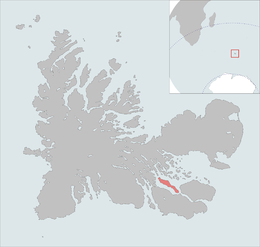 The île Longue is highlighted on this Kerguelen Islands map. | |
| Geography | |
|---|---|
| Location | Indian Ocean |
| Coordinates | 49°32′S 69°54′E |
| Archipelago | Îles Kerguelen |
| Area | 35.0 km2 (13.5 sq mi) |
| Highest elevation | 270 m (890 ft) |
| Highest point | Pic d'Antoine |
| Administration | |
| District | Îles Kerguelen |
| Demographics | |
| Population | 0 |
The highest point is a mountain named Pic d'Antoine, at 270 metres.
Since 1950 the islands hosts about 3500 free range sheep bred in order to provide fresh meat to the Port-aux-Français settlement.[1]
References
- Kerguelen islands map, Géoportail IGN.
- General view of non-metropolitan France, Maison de la Géographie.
This French Southern Territories location article is a stub. You can help Wikipedia by expanding it. |
На других языках
- [en] Île Longue (Kerguelen Islands)
[fr] Île Longue (îles Kerguelen)
L'île Longue est une île française de l'océan Indien située aux îles Kerguelen au fond du golfe du Morbihan. Elle mesure environ dix-sept kilomètres de long pour deux de large.Текст в блоке "Читать" взят с сайта "Википедия" и доступен по лицензии Creative Commons Attribution-ShareAlike; в отдельных случаях могут действовать дополнительные условия.
Другой контент может иметь иную лицензию. Перед использованием материалов сайта WikiSort.org внимательно изучите правила лицензирования конкретных элементов наполнения сайта.
Другой контент может иметь иную лицензию. Перед использованием материалов сайта WikiSort.org внимательно изучите правила лицензирования конкретных элементов наполнения сайта.
2019-2025
WikiSort.org - проект по пересортировке и дополнению контента Википедии
WikiSort.org - проект по пересортировке и дополнению контента Википедии