geo.wikisort.org - Island
Van Rocks are very conspicuous pinnacle rocks lying close west of Cape James, Smith Island, in the South Shetland Islands. They were roughly shown as a small island on a chart resulting from a British expedition under Foster, 1828–31, and then more accurately delineated by the Falkland Islands Dependencies Survey (FIDS) in 1959 from air photos taken by the Falkland Islands and Dependencies Aerial Survey Expedition (FIDASE), 1955–57. They were named by the United Kingdom Antarctic Place-Names Committee (UK-APC) because they mark the first or westernmost of the South Shetland Islands.[1]
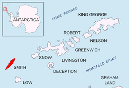 Location of Smith Island in the South Shetland Islands | |
 Van Rocks Location in Antarctica | |
| Geography | |
|---|---|
| Location | Antarctica |
| Coordinates | 63°6′S 62°50′W |
| Archipelago | South Shetland Islands |
| Administration | |
| Administered under the Antarctic Treaty System | |
| Demographics | |
| Population | Uninhabited |

Maps
- Chart of South Shetland including Coronation Island, &c. from the exploration of the sloop Dove in the years 1821 and 1822 by George Powell Commander of the same. Scale ca. 1:200000. London: Laurie, 1822.
- L.L. Ivanov. Antarctica: Livingston Island and Greenwich, Robert, Snow and Smith Islands. Scale 1:120000 topographic map. Troyan: Manfred Wörner Foundation, 2010. ISBN 978-954-92032-9-5 (First edition 2009. ISBN 978-954-92032-6-4)
- South Shetland Islands: Smith and Low Islands. Scale 1:150000 topographic map No. 13677. British Antarctic Survey, 2009.
- Antarctic Digital Database (ADD). Scale 1:250000 topographic map of Antarctica. Scientific Committee on Antarctic Research (SCAR). Since 1993, regularly upgraded and updated.
- L.L. Ivanov. Antarctica: Livingston Island and Smith Island. Scale 1:100000 topographic map. Manfred Wörner Foundation, 2017. ISBN 978-619-90008-3-0
References
- Van Rocks on geographic.org
![]() This article incorporates public domain material from the United States Geological Survey document: "Van Rocks". (content from the Geographic Names Information System)
This article incorporates public domain material from the United States Geological Survey document: "Van Rocks". (content from the Geographic Names Information System)
This Smith Island (South Shetland Islands) location article is a stub. You can help Wikipedia by expanding it. |
На других языках
[de] Van Rocks
Die Van Rocks (von englisch van ‚zuvorderst, an vorderster Front‘ bzw. als Kurzform von englisch vanguard ‚Vorhut, Vortrupp‘) sind zwei Gruppen[1] auffälliger spitzer Klippen im Archipel der Südlichen Shetlandinseln. Sie liegen westlich des Kap James, der Südspitze von Smith Island, in einer Entfernung von 3 bis 5 km.- [en] Van Rocks
Другой контент может иметь иную лицензию. Перед использованием материалов сайта WikiSort.org внимательно изучите правила лицензирования конкретных элементов наполнения сайта.
WikiSort.org - проект по пересортировке и дополнению контента Википедии