geo.wikisort.org - Island
Store Sommarøya or Sommarøya is an island in Tromsø Municipality in Troms og Finnmark county, Norway. The 0.9-square-kilometre (220-acre) island is located about 36 kilometres (22 mi) west of the city of Tromsø and is a popular tourist destination due to its white sand beaches and scenery. The island is connected to the large neighboring island of Kvaløya by the Sommarøy Bridge and it is connected to the small island of Hillesøya by the Hillesøy Bridge. The fishing village of Sommarøy covers Store Sommarøya and part of Hillesøya.[1]
 View of the island | |
 | |
 Store Sommarøya Location of the island  Store Sommarøya Store Sommarøya (Norway) | |
| Geography | |
|---|---|
| Location | Troms og Finnmark, Norway |
| Coordinates | 69.6272°N 18.0300°E |
| Area | 0.9 km2 (0.35 sq mi) |
| Length | 2 km (1.2 mi) |
| Width | 750 m (2460 ft) |
| Highest elevation | 55 m (180 ft) |
| Administration | |
Norway | |
| County | Troms og Finnmark |
| Municipality | Tromsø Municipality |
Climate
Despite its extreme latitude, more than 300 kilometres (190 mi) north of the Arctic Circle, Sommarøya experiences an ocean-moderated subarctic climate (Cfc) with no month averaging below −2 °C (28 °F) and a mean annual temperature of almost 4 °C (39 °F).
| Climate data for Sommarøy, Norway 1981 - 2010, | |||||||||||||
|---|---|---|---|---|---|---|---|---|---|---|---|---|---|
| Month | Jan | Feb | Mar | Apr | May | Jun | Jul | Aug | Sep | Oct | Nov | Dec | Year |
| Daily mean °C (°F) | −1.9 (28.6) |
−1.9 (28.6) |
−1.0 (30.2) |
1.7 (35.1) |
5.5 (41.9) |
8.9 (48.0) |
11.9 (53.4) |
11.4 (52.5) |
8.1 (46.6) |
4.5 (40.1) |
1.0 (33.8) |
−1.1 (30.0) |
3.9 (39.1) |
| Average precipitation mm (inches) | 81 (3.2) |
72 (2.8) |
67 (2.6) |
58 (2.3) |
48 (1.9) |
59 (2.3) |
65 (2.6) |
73 (2.9) |
93 (3.7) |
123 (4.8) |
99 (3.9) |
102 (4.0) |
940 (37) |
| Source: [2] | |||||||||||||
Media gallery
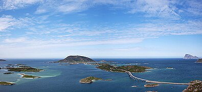 View to Sommarøya and Hillesøya
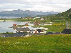 Looking south
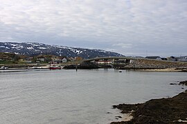 Looking south from Hillesøya to Sommarøy
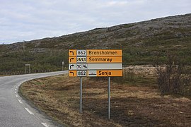 Road sign in Sandvika on riksvei 862 outside of Tromsø


See also
References
- Thorsnæs, Geir, ed. (2018-06-25). "Store Sommarøya". Store norske leksikon (in Norwegian). Kunnskapsforlaget. Retrieved 2018-08-11.
- Norwegian Meteorological Institute's eklima site
Другой контент может иметь иную лицензию. Перед использованием материалов сайта WikiSort.org внимательно изучите правила лицензирования конкретных элементов наполнения сайта.
WikiSort.org - проект по пересортировке и дополнению контента Википедии